
, Aubrey Burl")
<< Our Photo Pages >> The Giant's Grave Mardon Down - Cairn in England in Devon
Submitted by AngieLake on Saturday, 22 November 2008 Page Views: 10063
Neolithic and Bronze AgeSite Name: The Giant's Grave Mardon Down Alternative Name: Marden Down Giant's Grave 4; Mardon Down cairn 4; Grinsell Moretonhampstead 3Country: England County: Devon Type: Cairn
Nearest Town: Moretonhampstead
Map Ref: SX76768746
Latitude: 50.673718N Longitude: 3.745477W
Condition:
| 5 | Perfect |
| 4 | Almost Perfect |
| 3 | Reasonable but with some damage |
| 2 | Ruined but still recognisable as an ancient site |
| 1 | Pretty much destroyed, possibly visible as crop marks |
| 0 | No data. |
| -1 | Completely destroyed |
| 5 | Superb |
| 4 | Good |
| 3 | Ordinary |
| 2 | Not Good |
| 1 | Awful |
| 0 | No data. |
| 5 | Can be driven to, probably with disabled access |
| 4 | Short walk on a footpath |
| 3 | Requiring a bit more of a walk |
| 2 | A long walk |
| 1 | In the middle of nowhere, a nightmare to find |
| 0 | No data. |
| 5 | co-ordinates taken by GPS or official recorded co-ordinates |
| 4 | co-ordinates scaled from a detailed map |
| 3 | co-ordinates scaled from a bad map |
| 2 | co-ordinates of the nearest village |
| 1 | co-ordinates of the nearest town |
| 0 | no data |
Internal Links:
External Links:
I have visited· I would like to visit
Catrinm visited on 2nd May 2022 - their rating: Cond: 2 Amb: 4 Access: 4
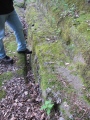
TheCaptain visited on 26th Feb 2019 - their rating: Cond: 2 Amb: 3 Access: 3 At the top of the hill, and there is a fairly large cleared green area, but the Giant's Grave cairn is very disappointing, being not much more than a large bumpy area of ground, of about 20m diameter. It certainly doesn't live up to its name.
AngieLake have visited here
Average ratings for this site from all visit loggers: Condition: 2 Ambience: 3.5 Access: 3.5
")
Though the general ambience of Mardon Down is excellent, we were very disappointed by the appearance of the cairn known as the Giant's Grave as it was no more than a wide but shallow heap of lumpy vegetation. Again, we would not have noticed it without Butler's invaluable 'Dartmoor Atlas of Antiquities, Vol. 5'.
He says:
"A few metres from the ring cairn the ridgeway track continues northwards before being deflected around a pair of large cairns on the highest point." .... "4" [ref to his map, a sketch copy of which is on site page for the circle, Mardon Down S], "is now known as the Giant's Grave, though it can hardly have been the one referred to by Shortt (1841) and Rowe (1848) 'on the south-east side of the hill' which was 'nearly obliterated' for road repairs, for much of this structure survives as an amorphous much-spread mound." ....
"Spence Bate also refers to yet another 'giant's grave ... nine yards round' on Mardon Hill, apparently undamaged before being 'opened some years before' 1873; in a cist of 'six great stones' were found 'a spearhead of copper, two pegs or screws which fastened it to its shaft, a glass British bead and a small amulet of soft stone, calcined bones, ashes etc..'"
Update October 2019: This cairn is featured on the Prehistoric Dartmoor Walks (PDW) website - see their entry for the Giant's Grave Cairn, which tells us this is: "(the) remains of a cairn which was largely destroyed in the early 19th century when material from it was removed for road building. Now a turf-covered mound 20.5 metres diameter and 0.6 metres high".
The cairn is also recorded as Pastscape Monument No. 445366 and as MDV8309 (Giant's Grave Cairn, Mardon Down) on the Devon and Dartmoor HER, which adds that this is "part of a line of monuments along the ridge on Mardon Down".
You may be viewing yesterday's version of this page. To see the most up to date information please register for a free account.
")
")
")
")
")
")
Do not use the above information on other web sites or publications without permission of the contributor.
Click here to see more info for this site
Nearby sites
Key: Red: member's photo, Blue: 3rd party photo, Yellow: other image, Green: no photo - please go there and take one, Grey: site destroyed
Download sites to:
KML (Google Earth)
GPX (GPS waypoints)
CSV (Garmin/Navman)
CSV (Excel)
To unlock full downloads you need to sign up as a Contributory Member. Otherwise downloads are limited to 50 sites.
Turn off the page maps and other distractions
Nearby sites listing. In the following links * = Image available
31m SSE 152° Mardon Down Cairn 3* Cairn (SX7677487432)
117m SSE 159° Mardon Down Mortar Pit* Modern Stone Circle etc (SX76808735)
198m NE 44° Marden Down East* Ring Cairn (SX76908760)
198m S 188° Mardon Down Ring Cairn* Ring Cairn (SX7672987264)
220m N 356° Mardon Down N* Stone Circle (SX76758768)
270m S 179° Mardon Down S* Stone Circle (SX76768719)
300m S 179° Mardon Down Cairn 1* Cairn (SX76768716)
460m NE 39° Headless Cross (Moretonhampstead)* Modern Stone Circle etc (SX77068781)
1.9km SW 220° Moretonhampstead Cross* Ancient Cross (SX7550886039)
1.9km N 354° Wooston Castle* Hillfort (SX76608935)
2.0km WNW 298° Butterdon Down Cairns* Barrow Cemetery (SX75028843)
2.1km SSW 193° One Mill Bridge Cross* Ancient Cross (SX76268544)
2.2km WNW 294° Butterdon Down West* Standing Stone (Menhir) (SX74788840)
3.2km NW 306° Charles Cross* Ancient Cross (SX742894)
3.3km NW 321° Prestonbury Castle* Hillfort (SX7477490045)
3.3km WNW 297° Cranbrook Castle* Hillfort (SX7386889010)
3.7km SW 221° Horspit Cross* Ancient Cross (SX7430684741)
3.8km S 178° Sanduck Cross* Ancient Cross (SX7681983610)
4.2km WSW 258° Meacombe Cist Landscape Natural Stone / Erratic / Other Natural Feature (SX726867)
4.3km W 261° Meacombe Cist* Burial Chamber or Dolmen (SX7249486904)
4.5km SW 216° North Bovey* Ancient Cross (SX7399083879)
5.0km SSE 167° Higher Combe Cross* Ancient Cross (SX7776482535)
5.1km S 185° Hunter's Tor Fort* Hillfort (SX7616482412)
5.2km S 173° South Harton Cross* Ancient Cross (SX7724982273)
5.2km WSW 255° Chagford Druid's Well* Holy Well or Sacred Spring (SX71658625)
View more nearby sites and additional images


 We would like to know more about this location. Please feel free to add a brief description and any relevant information in your own language.
 Wir möchten mehr über diese Stätte erfahren. Bitte zögern Sie nicht, eine kurze Beschreibung und relevante Informationen in Deutsch hinzuzufügen.
 Nous aimerions en savoir encore un peu sur les lieux. S'il vous plaît n'hesitez pas à ajouter une courte description et tous les renseignements pertinents dans votre propre langue.
 Quisieramos informarnos un poco más de las lugares. No dude en añadir una breve descripción y otros datos relevantes en su propio idioma.