<< Our Photo Pages >> Cefn Cnwcheithinog - Standing Stone (Menhir) in Wales in Ceredigion
Submitted by Andy B on Saturday, 03 October 2020 Page Views: 741
Neolithic and Bronze AgeSite Name: Cefn CnwcheithinogCountry: Wales County: Ceredigion Type: Standing Stone (Menhir)
Map Ref: SN757496
Latitude: 52.130682N Longitude: 3.817349W
Condition:
| 5 | Perfect |
| 4 | Almost Perfect |
| 3 | Reasonable but with some damage |
| 2 | Ruined but still recognisable as an ancient site |
| 1 | Pretty much destroyed, possibly visible as crop marks |
| 0 | No data. |
| -1 | Completely destroyed |
| 5 | Superb |
| 4 | Good |
| 3 | Ordinary |
| 2 | Not Good |
| 1 | Awful |
| 0 | No data. |
| 5 | Can be driven to, probably with disabled access |
| 4 | Short walk on a footpath |
| 3 | Requiring a bit more of a walk |
| 2 | A long walk |
| 1 | In the middle of nowhere, a nightmare to find |
| 0 | No data. |
| 5 | co-ordinates taken by GPS or official recorded co-ordinates |
| 4 | co-ordinates scaled from a detailed map |
| 3 | co-ordinates scaled from a bad map |
| 2 | co-ordinates of the nearest village |
| 1 | co-ordinates of the nearest town |
| 0 | no data |
Internal Links:
External Links:
I have visited· I would like to visit
Geojazz visited on 4th Jul 2021 - their rating: Cond: 4 Amb: 4 Access: 2
Penbron have visited here
")
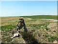
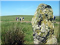
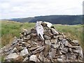
It is aligned NE-SW. It measures 1.6m in height. The base measures c. 0.5m in width and 0.47m in depth. Packing stones are visible at the base of the stone.
Source: CADW
You may be viewing yesterday's version of this page. To see the most up to date information please register for a free account.
")
")
")
Do not use the above information on other web sites or publications without permission of the contributor.
Nearby Images from Geograph Britain and Ireland:
©2023(licence)
©2014(licence)
©2012(licence)
©2008(licence)
©2008(licence)
The above images may not be of the site on this page, they are loaded from Geograph.
Please Submit an Image of this site or go out and take one for us!
Click here to see more info for this site
Nearby sites
Key: Red: member's photo, Blue: 3rd party photo, Yellow: other image, Green: no photo - please go there and take one, Grey: site destroyed
Download sites to:
KML (Google Earth)
GPX (GPS waypoints)
CSV (Garmin/Navman)
CSV (Excel)
To unlock full downloads you need to sign up as a Contributory Member. Otherwise downloads are limited to 50 sites.
Turn off the page maps and other distractions
Nearby sites listing. In the following links * = Image available
2.0km W 261° Cefn Gwernffrwd stone circle* Stone Circle (SN7370049328)
2.0km W 261° Cefn Gwernffrwd Row* Stone Row / Alignment (SN7370049328)
2.4km S 183° Cefn Gwenffrwd Maenhir* Standing Stone (Menhir) (SN75514725)
2.6km S 176° Randirmwyn Standing Stone* Standing Stone (Menhir) (SN758470)
3.5km WSW 241° Esgair Nant-y-Maen cairn* Ring Cairn (SN72544798)
3.6km NNE 23° Carn Saith-Wraig, Round Cairn* Round Cairn (SN77185288)
3.6km NNE 21° Carn Saith-Wraig, Ring Cairn* Ring Cairn (SN77105297)
4.0km SSE 159° Gelli Burial Chamber* Chambered Cairn (SN7703845843)
4.0km NNE 14° Blaen nant y Rhiw Round Cairn* Cairn (SN76765347)
4.1km SSE 151° Ty Newydd Standing Stone* Standing Stone (Menhir) (SN776460)
4.4km NNE 33° Nant Llwyd Standing Stones* Standing Stones (SN782532)
5.2km N 350° Bryn y Gorlan* Stone Circle (SN74945473)
5.2km SSW 209° Maen Bach* Standing Stone (Menhir) (SN73084507)
5.3km SW 218° Crugiau Merched Cairn 2 Cairn (SN72324557)
5.3km SW 219° Crugiau Merched* Cairn (SN72274555)
5.3km SSW 202° Mynydd Mallaen* Standing Stone (Menhir) (SN73564471)
5.4km SW 219° Crugiau Merched, Cairn 1* Cairn (SN72214553)
5.4km ESE 123° Cerrig Cedny* Cairn (SN80144651)
5.7km SE 124° Carn Twrch* Cairn (SN80344630)
5.8km ESE 107° Cefn Ystrad Ffin Cairn* Cairn (SN81234776)
5.9km WSW 256° Crug Siarls* Stone Circle (SN69954830)
6.0km SE 135° Carn Wen (Rhandirmwyn)* Cairn (SN79834527)
6.0km SE 128° Carreg Craig y Moch Standing Stone (Menhir) (SN804458)
6.2km E 98° Mynydd Trawsnant Cairn* Cairn (SN81834863)
6.8km SSE 162° Dinas Bach (Cilycwm)* Hillfort (SN77704310)
View more nearby sites and additional images


 We would like to know more about this location. Please feel free to add a brief description and any relevant information in your own language.
 Wir möchten mehr über diese Stätte erfahren. Bitte zögern Sie nicht, eine kurze Beschreibung und relevante Informationen in Deutsch hinzuzufügen.
 Nous aimerions en savoir encore un peu sur les lieux. S'il vous plaît n'hesitez pas à ajouter une courte description et tous les renseignements pertinents dans votre propre langue.
 Quisieramos informarnos un poco más de las lugares. No dude en añadir una breve descripción y otros datos relevantes en su propio idioma.