<< Our Photo Pages >> Alltwen Hillfort - Hillfort in Wales in Conwy
Submitted by raythemapman on Saturday, 03 July 2010 Page Views: 10321
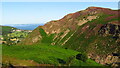
Iron Age and Later PrehistorySite Name: Alltwen Hillfort Alternative Name: Sychnant PassCountry: Wales County: Conwy Type: Hillfort
Nearest Town: Conwy Nearest Village: Dwygyfylchi
Map Ref: SH745773
Latitude: 53.277780N Longitude: 3.883657W
Condition:
| 5 | Perfect |
| 4 | Almost Perfect |
| 3 | Reasonable but with some damage |
| 2 | Ruined but still recognisable as an ancient site |
| 1 | Pretty much destroyed, possibly visible as crop marks |
| 0 | No data. |
| -1 | Completely destroyed |
| 5 | Superb |
| 4 | Good |
| 3 | Ordinary |
| 2 | Not Good |
| 1 | Awful |
| 0 | No data. |
| 5 | Can be driven to, probably with disabled access |
| 4 | Short walk on a footpath |
| 3 | Requiring a bit more of a walk |
| 2 | A long walk |
| 1 | In the middle of nowhere, a nightmare to find |
| 0 | No data. |
| 5 | co-ordinates taken by GPS or official recorded co-ordinates |
| 4 | co-ordinates scaled from a detailed map |
| 3 | co-ordinates scaled from a bad map |
| 2 | co-ordinates of the nearest village |
| 1 | co-ordinates of the nearest town |
| 0 | no data |
Internal Links:
External Links:
I have visited· I would like to visit
Klingon visited on 23rd Oct 2022 - their rating: Cond: 2 Amb: 5 Access: 2
")
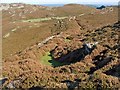
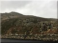
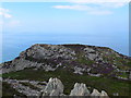
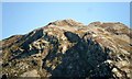
Alltwen Hillfort, near Sychnant Pass
You may be viewing yesterday's version of this page. To see the most up to date information please register for a free account.
")
")
")
Do not use the above information on other web sites or publications without permission of the contributor.
Nearby Images from Geograph Britain and Ireland:
©2008(licence)
©2024(licence)
©2009(licence)
©2013(licence)
©2021(licence)
The above images may not be of the site on this page, they are loaded from Geograph.
Please Submit an Image of this site or go out and take one for us!
Click here to see more info for this site
Nearby sites
Key: Red: member's photo, Blue: 3rd party photo, Yellow: other image, Green: no photo - please go there and take one, Grey: site destroyed
Download sites to:
KML (Google Earth)
GPX (GPS waypoints)
CSV (Garmin/Navman)
CSV (Excel)
To unlock full downloads you need to sign up as a Contributory Member. Otherwise downloads are limited to 50 sites.
Turn off the page maps and other distractions
Nearby sites listing. In the following links * = Image available
1.5km S 173° Llyn-y-Wrach* Ring Cairn (SH74657578)
1.6km ENE 70° Conway Mountain* Hillfort (SH760778)
2.0km S 172° Hafodty* Stone Circle (SH74747532)
2.2km S 182° Fairy Glen Settlement* Ancient Village or Settlement (SH74387513)
2.2km S 179° Tydden-Grasod* Cist (SH74487508)
2.4km S 172° Maen Hir (Conwy)* Standing Stone (Menhir) (SH74787496)
2.4km S 184° Waen Gyrach* Ring Cairn (SH74277493)
2.6km SSW 208° Red Farm* Stone Circle (SH73227505)
2.7km SSW 210° Maen Crwn* Standing Stone (Menhir) (SH73107499)
3.1km SW 216° Fridd Wanc* Round Barrow(s) (SH726748)
3.2km SW 217° Circle 275* Stone Circle (SH7251174774)
3.2km SSE 164° Northern Hut Group* Ancient Village or Settlement (SH75337418)
3.3km SSE 164° Southern Hut Group Ancient Village or Settlement (SH75347413)
3.4km SW 218° Druids Circle (Penmaenmawr)* Stone Circle (SH72297466)
3.5km SSE 163° Cerrig-Y-Ddinas* Hillfort (SH75427395)
3.5km SW 219° Monument 280* Ring Cairn (SH72207464)
3.6km SW 219° Cefn Coch (Penmaenmawr)* Ring Cairn (SH72167457)
3.6km SSW 210° Cerrig Gwynion (Conwy)* Cist (SH72627423)
3.7km S 169° St Celynin's Well* Holy Well or Sacred Spring (SH75127369)
3.7km SW 228° Graig Lwyd Neolithic Axe Factory* Ancient Mine, Quarry or other Industry (SH71707490)
3.7km S 169° Ffynnon Gelynin Hut Circle Ancient Village or Settlement (SH75117366)
3.7km SW 224° Cors Y Carneddau* Stone Circle (SH71847467)
3.8km S 189° Cefn Maen Amor* Stone Circle (SH73847359)
3.8km S 188° Maen Penddu* Standing Stone (Menhir) (SH73907357)
3.8km SW 226° Graig Lwyd Cairns* Cairn (SH717747)
View more nearby sites and additional images


 We would like to know more about this location. Please feel free to add a brief description and any relevant information in your own language.
 Wir möchten mehr über diese Stätte erfahren. Bitte zögern Sie nicht, eine kurze Beschreibung und relevante Informationen in Deutsch hinzuzufügen.
 Nous aimerions en savoir encore un peu sur les lieux. S'il vous plaît n'hesitez pas à ajouter une courte description et tous les renseignements pertinents dans votre propre langue.
 Quisieramos informarnos un poco más de las lugares. No dude en añadir una breve descripción y otros datos relevantes en su propio idioma.