

<< Our Photo Pages >> Thornworthy Little Common - Stone Row / Alignment in England in Devon
Submitted by TimPrevett on Tuesday, 01 October 2002 Page Views: 7540
Neolithic and Bronze AgeSite Name: Thornworthy Little CommonCountry: England
NOTE: This site is 0.6 km away from the location you searched for.
County: Devon Type: Stone Row / Alignment
Nearest Town: Lynton Nearest Village: Barbrook
Map Ref: SS71264381 Landranger Map Number: 180
Latitude: 51.178986N Longitude: 3.843187W
Condition:
| 5 | Perfect |
| 4 | Almost Perfect |
| 3 | Reasonable but with some damage |
| 2 | Ruined but still recognisable as an ancient site |
| 1 | Pretty much destroyed, possibly visible as crop marks |
| 0 | No data. |
| -1 | Completely destroyed |
| 5 | Superb |
| 4 | Good |
| 3 | Ordinary |
| 2 | Not Good |
| 1 | Awful |
| 0 | No data. |
| 5 | Can be driven to, probably with disabled access |
| 4 | Short walk on a footpath |
| 3 | Requiring a bit more of a walk |
| 2 | A long walk |
| 1 | In the middle of nowhere, a nightmare to find |
| 0 | No data. |
| 5 | co-ordinates taken by GPS or official recorded co-ordinates |
| 4 | co-ordinates scaled from a detailed map |
| 3 | co-ordinates scaled from a bad map |
| 2 | co-ordinates of the nearest village |
| 1 | co-ordinates of the nearest town |
| 0 | no data |
Internal Links:
External Links:
I have visited· I would like to visit
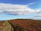
SandyG visited on 20th Apr 2018 - their rating: Cond: 2 Amb: 3 Access: 3 Limited car parking is available at SS 71410 44956 at Shallowford. From here head south along the path to SS 71330 43866 and enter the field on your right. From here it is a short walk to the row which may be difficult to find in the dense undergrowth.
TimPrevett have visited here
")
Notes from SandyG.
Only three stones were found because of dense vegetation covering most of the row.
Stone 1 at SS 71267 43813 measures 0.18m long by 0.10m wide and stands up to 0.14m high.
Stone 2 at SS 71262 43812 measures 0.23m long by 0.16m wide and stands up to 0.19m high.
Stone 3 at SS 71256 43811 measures 0.14m long by 0.10m wide and stands up to 0.01m high.
Update September 2019: This stone row is featured on the Stone Rows of Great Britain website - see their entry for Thornworthy Little Common, which includes a description, photographs, and a section describing and illustrating the Restricted Sea Views from the row of the Bristol Channel and the South Wales Coast, indicating the row may have been built across the line of visibility to the sea.
The row is also recorded as Pastscape Monument No. 870511, which describes up to 16 stones in the row. The Exmoor National Park HER also includes an entry; see MDE8974 (Prehistoric stone row on Thornworthy Little Common), which includes a detailed description.
You may be viewing yesterday's version of this page. To see the most up to date information please register for a free account.
")
")
")
Do not use the above information on other web sites or publications without permission of the contributor.
Nearby Images from Geograph Britain and Ireland:

©2020(licence)

©2017(licence)

©2017(licence)

©2008(licence)

©2016(licence)
The above images may not be of the site on this page, they are loaded from Geograph.
Please Submit an Image of this site or go out and take one for us!
Click here to see more info for this site
Nearby sites
Key: Red: member's photo, Blue: 3rd party photo, Yellow: other image, Green: no photo - please go there and take one, Grey: site destroyed
Download sites to:
KML (Google Earth)
GPX (GPS waypoints)
CSV (Garmin/Navman)
CSV (Excel)
To unlock full downloads you need to sign up as a Contributory Member. Otherwise downloads are limited to 50 sites.
![]()
Turn off the page maps and other distractions
Nearby sites listing. In the following links * = Image available
998m E 91° Winnaway* Stone Row / Alignment (SS72264376)
1.0km SSE 164° Woodbarrow Hangings* Multiple Stone Rows / Avenue (SS71514283)
1.1km SW 224° Longstone (Challacombe)* Standing Stone (Menhir) (SS70514307)
1.2km SSW 208° Longstone Barrow* Round Barrow(s) (SS707428)
1.2km NE 39° Ilkerton Ridge stones* Standing Stones (SS72074475)
1.3km NNE 29° Ilkerton Ridge Barrows* Barrow Cemetery (SS719449)
1.4km SSE 164° Woodbarrow (Exmoor)* Round Barrow(s) (SS716425)
1.4km SSW 199° Longstone Barrow Row* Stone Row / Alignment (SS70774252)
1.4km WSW 243° Chapman Down Barrow* Round Barrow(s) (SS700432)
1.5km WSW 257° Chapman Barrows* Barrow Cemetery (SS698435)
1.5km S 171° Woodbarrow Stone Setting* Multiple Stone Rows / Avenue (SS71474233)
1.5km WSW 250° Chapman Barrows Quincunx* Standing Stones (SS69794333)
1.6km ESE 102° Benjamy* Stone Row / Alignment (SS72804344)
1.6km ENE 76° Warcombe Water stone* Standing Stone (Menhir) (SS72854417)
1.7km ENE 73° Warcombe Water row* Stone Row / Alignment (SS72864424)
1.8km WNW 299° South Common Settlement* Ancient Village or Settlement (SS69704474)
2.0km ENE 72° Furzehill Common Barrow* Round Barrow(s) (SS732444)
2.2km ENE 70° Furzehill Common 0* Standing Stones (SS73324451)
2.3km E 86° Furzehill Common 1* Stone Row / Alignment (SS7351843922)
2.3km ENE 71° Furzehill Common cairn* Cairn (SS73444451)
2.3km WNW 297° Woolhanger henge* Henge (SS692449)
2.5km ENE 78° Furzehill Common 2* Standing Stones (SS73744425)
2.6km E 85° Furzehill Common stone row * Stone Row / Alignment (SS73844396)
2.7km E 89° Hoaroak 1* Multiple Stone Rows / Avenue (SS7397543789)
2.7km ENE 64° Furzehill Common Standing Stone* Standing Stone (Menhir) (SS73754494)
View more nearby sites and additional images


 We would like to know more about this location. Please feel free to add a brief description and any relevant information in your own language.
 Wir möchten mehr über diese Stätte erfahren. Bitte zögern Sie nicht, eine kurze Beschreibung und relevante Informationen in Deutsch hinzuzufügen.
 Nous aimerions en savoir encore un peu sur les lieux. S'il vous plaît n'hesitez pas à ajouter une courte description et tous les renseignements pertinents dans votre propre langue.
 Quisieramos informarnos un poco más de las lugares. No dude en añadir una breve descripción y otros datos relevantes en su propio idioma.