


<< Our Photo Pages >> Carreg Pumsaint - Standing Stone (Menhir) in Wales in Carmarthenshire (Sir Caerfyrddin)
Submitted by PaulM on Wednesday, 03 March 2004 Page Views: 17671
Neolithic and Bronze AgeSite Name: Carreg PumsaintCountry: Wales County: Carmarthenshire (Sir Caerfyrddin) Type: Standing Stone (Menhir)
Nearest Village: Pumsaint
Map Ref: SN66334035 Landranger Map Number: 146
Latitude: 52.045379N Longitude: 3.950525W
Condition:
| 5 | Perfect |
| 4 | Almost Perfect |
| 3 | Reasonable but with some damage |
| 2 | Ruined but still recognisable as an ancient site |
| 1 | Pretty much destroyed, possibly visible as crop marks |
| 0 | No data. |
| -1 | Completely destroyed |
| 5 | Superb |
| 4 | Good |
| 3 | Ordinary |
| 2 | Not Good |
| 1 | Awful |
| 0 | No data. |
| 5 | Can be driven to, probably with disabled access |
| 4 | Short walk on a footpath |
| 3 | Requiring a bit more of a walk |
| 2 | A long walk |
| 1 | In the middle of nowhere, a nightmare to find |
| 0 | No data. |
| 5 | co-ordinates taken by GPS or official recorded co-ordinates |
| 4 | co-ordinates scaled from a detailed map |
| 3 | co-ordinates scaled from a bad map |
| 2 | co-ordinates of the nearest village |
| 1 | co-ordinates of the nearest town |
| 0 | no data |
Internal Links:
External Links:
I have visited· I would like to visit
Penbron SandyG have visited here
")
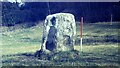
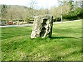
The stone at Carreg Pumsaint near the Dolaucothi gold mines, after which the village was named. Legend had it that five saints rested on the stone (one on each face and one on top) - the devil came along, saw them and stuck them to it. Merlin then released them but the stone is still marked where the saints were stuck.
In reality the stone is believed to have been an anvil for ore crushing and would have lain on its side. NGR: SN663403.
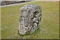
Update January 2019: This standing stone is recorded as Coflein NPRN 303909. The Journal of Antiquities also includes an entry on this stone - scroll down their entry for the Dolaucothi Roman Mines, Pumsaint, Carmarthenshire, which includes some background information, a photograph and local folklore. The Journal adds: "Near the entrance to the Roman mine on a low mound there is a small standing stone (Carreg Pumsaint) which, according to legend, is associated with five Celtic saints who lived as a hermits here in the 6C AD. There names were Ceitho, Celynin, Gwyn, Gwynaro and Gwynog. They were the sons of Cynyr Farfdrwch, a prince of Pembrokeshire, at the time of St David …. There are said to be five hollows in the stone where the saints lay their heads – although today there only seem to be four hollows in the stone".
You may be viewing yesterday's version of this page. To see the most up to date information please register for a free account.
")
")
")
Do not use the above information on other web sites or publications without permission of the contributor.
Nearby Images from Geograph Britain and Ireland:
©2021(licence)
©2013(licence)

©2025(licence)

©2013(licence)
©2007(licence)
The above images may not be of the site on this page, they are loaded from Geograph.
Please Submit an Image of this site or go out and take one for us!
Click here to see more info for this site
Nearby sites
Key: Red: member's photo, Blue: 3rd party photo, Yellow: other image, Green: no photo - please go there and take one, Grey: site destroyed
Download sites to:
KML (Google Earth)
GPX (GPS waypoints)
CSV (Garmin/Navman)
CSV (Excel)
To unlock full downloads you need to sign up as a Contributory Member. Otherwise downloads are limited to 50 sites.
Turn off the page maps and other distractions
Nearby sites listing. In the following links * = Image available
112m SSE 152° Dolaucothi* Ancient Mine, Quarry or other Industry (SN66384025)
4.1km NE 50° Maes-yr-haidd Round Barrow II* Cairn (SN6954242882)
4.2km NE 49° Maes-yr-haidd Round Barrow I* Cairn (SN6960042991)
4.8km E 99° Nant-Iwrch Cairn* Ring Cairn (SN71043946)
5.8km NE 56° Rhiw Garegog Round barrows* Round Barrow(s) (SN71214346)
5.8km NE 55° Rhiw Garegog Ditch* Misc. Earthwork (SN71184352)
5.8km ENE 60° Rhiw Garegog Scoop Grave 1 Misc. Earthwork (SN71414314)
5.8km NE 55° Rhiw Gwaregog Standing Stone Standing Stone (Menhir) (SN71184354)
5.8km NE 56° Rhiw Garegog Standing Stone II* Standing Stone (Menhir) (SN71264349)
5.9km ENE 59° Rhiw Garegog Scoop Grave 2 Misc. Earthwork (SN71474323)
5.9km NE 55° Rhiwgaregog Standing Stone (recumbent)* Standing Stone (Menhir) (SN71274364)
5.9km ESE 116° Berrisbrook Standing Stones* Standing Stone (Menhir) (SN71603761)
7.2km NW 326° Hirfaen Gwyddog* Standing Stone (Menhir) (SN62454645)
7.7km NNW 346° Carreg Y Bwci* Cairn (SN646479)
7.8km NNW 329° Bryn Goleu* Cairn (SN62434712)
7.8km NE 47° Crugiau Merched, Cairn 1* Cairn (SN72214553)
7.9km NE 47° Crugiau Merched* Cairn (SN72274555)
7.9km WNW 282° Blaen-Ceiment* Round Barrow(s) (SN58594216)
7.9km NE 47° Crugiau Merched Cairn 2 Cairn (SN72324557)
8.2km NE 53° Maen Bach* Standing Stone (Menhir) (SN73084507)
8.4km ENE 57° Mynydd Mallaen* Standing Stone (Menhir) (SN73564471)
8.5km W 280° Cefn Blaenau* Cairn (SN58034208)
8.5km SSE 161° Bryndyfan Standing Stone* Standing Stone (Menhir) (SN6886732240)
8.6km NNW 330° Caer Cadwgan Hillfort (SN62234796)
8.7km NNE 23° Crug Siarls* Stone Circle (SN69954830)
View more nearby sites and additional images


 We would like to know more about this location. Please feel free to add a brief description and any relevant information in your own language.
 Wir möchten mehr über diese Stätte erfahren. Bitte zögern Sie nicht, eine kurze Beschreibung und relevante Informationen in Deutsch hinzuzufügen.
 Nous aimerions en savoir encore un peu sur les lieux. S'il vous plaît n'hesitez pas à ajouter une courte description et tous les renseignements pertinents dans votre propre langue.
 Quisieramos informarnos un poco más de las lugares. No dude en añadir una breve descripción y otros datos relevantes en su propio idioma.