<< Our Photo Pages >> Chwarel Fawr Stones - Rock Art in Wales in Gwynedd
Submitted by pab on Thursday, 19 April 2012 Page Views: 5911
Rock ArtSite Name: Chwarel Fawr Stones Alternative Name: Chwarel Cefn DuCountry: Wales County: Gwynedd Type: Rock Art
Nearest Town: Llanberis
Map Ref: SH5549660004
Latitude: 53.117578N Longitude: 4.160632W
Condition:
| 5 | Perfect |
| 4 | Almost Perfect |
| 3 | Reasonable but with some damage |
| 2 | Ruined but still recognisable as an ancient site |
| 1 | Pretty much destroyed, possibly visible as crop marks |
| 0 | No data. |
| -1 | Completely destroyed |
| 5 | Superb |
| 4 | Good |
| 3 | Ordinary |
| 2 | Not Good |
| 1 | Awful |
| 0 | No data. |
| 5 | Can be driven to, probably with disabled access |
| 4 | Short walk on a footpath |
| 3 | Requiring a bit more of a walk |
| 2 | A long walk |
| 1 | In the middle of nowhere, a nightmare to find |
| 0 | No data. |
| 5 | co-ordinates taken by GPS or official recorded co-ordinates |
| 4 | co-ordinates scaled from a detailed map |
| 3 | co-ordinates scaled from a bad map |
| 2 | co-ordinates of the nearest village |
| 1 | co-ordinates of the nearest town |
| 0 | no data |
Internal Links:
External Links:
I have visited· I would like to visit
PAB has visited here
")
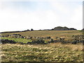
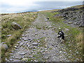
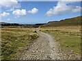
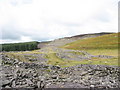
Near the trackway running above Llanberis, a grouping of rocks caught my eye as worth a bit of a detour. Expectations were fairly low, as this area has been extensively quarried - the name I have used to describe the location actually means quarry, and there are several shown on the relevant OS maps.
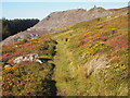
The stones themselves may not be an ancient construction, and there is nothing on COFLEIN in this precise spot, but the detour was definitely worth it for the view and for the markings on one of the stones.
This photo shows the markings - they are clearly man made, or at least the clustering & alignment almost certainly precludes any natural origin I could come up with! As with all things, very happy to be proved wrong.
Hopefully someone who has experience of quarrying can say whether this is normal use of the right sort of rock (sharpening tools etc)?
In the meantime, I have worked on the assumption that the cluster of rocks are not inherently 'megalithic', but that the markings are definitely man-made and look good, so constitute 'rock art' and I have used that term in posting this as a new site!
You may be viewing yesterday's version of this page. To see the most up to date information please register for a free account.
")
")
")
")
Do not use the above information on other web sites or publications without permission of the contributor.
Nearby Images from Geograph Britain and Ireland:
©2007(licence)
©2011(licence)
©2024(licence)
©2015(licence)
©2006(licence)
The above images may not be of the site on this page, they are loaded from Geograph.
Please Submit an Image of this site or go out and take one for us!
Click here to see more info for this site
Nearby sites
Key: Red: member's photo, Blue: 3rd party photo, Yellow: other image, Green: no photo - please go there and take one, Grey: site destroyed
Download sites to:
KML (Google Earth)
GPX (GPS waypoints)
CSV (Garmin/Navman)
CSV (Excel)
To unlock full downloads you need to sign up as a Contributory Member. Otherwise downloads are limited to 50 sites.
Turn off the page maps and other distractions
Nearby sites listing. In the following links * = Image available
1.8km N 353° Pen-y-bwlch settlement Ancient Village or Settlement (SH55336177)
1.8km NNW 339° Parc Y Gleision Hut Circle Settlement* Ancient Village or Settlement (SH549617)
2.0km NNW 334° Parc-y-Gleision Standing Stone* Standing Stone (Menhir) (SH54706180)
2.2km NW 318° Hafodlas Cairn Circle* Cairn (SH54056170)
3.0km E 93° Parc Bach* Chambered Tomb (SH5846359778)
3.4km WNW 296° Pant Ifan Maenhir* Standing Stone (Menhir) (SH52506160)
3.7km N 359° Cae Corniog Enclosed Hut Group* Ancient Village or Settlement (SH55576368)
3.9km NW 305° Pant Afon Bach Maenhir* Standing Stone (Menhir) (SH52366236)
4.2km WNW 299° Cilgwythwch Maenhir* Standing Stone (Menhir) (SH51866217)
4.5km N 349° Pen Y Gaer (Llanddeiniolen)* Hillfort (SH54776440)
4.7km SSW 193° Craig Cwmbychan Cairn* Cairn (SH54335542)
4.8km NNW 349° Glascoed Ancient Village* Ancient Village or Settlement (SH547647)
4.9km N 358° Ffynnon Cegin Arthur Holy Well or Sacred Spring (SH55486488)
5.0km N 349° Glyn Arthur* Cairn (SH547649)
5.0km NNE 19° Enclosed Hut Group SW of Cae'r Mynydd* Ancient Village or Settlement (SH57256469)
5.3km N 352° Dinas Dinorwig* Hillfort (SH549653)
5.4km NNE 12° Coed y Castell Enclosed Hut Circle Settlement* Ancient Village or Settlement (SH5681065230)
5.5km SSW 194° Mynydd Mawr Cairn* Cairn (SH53965469)
5.6km ESE 105° Ffynnon Peris* Holy Well or Sacred Spring (SH6084358359)
5.6km WSW 251° Gaerwen Ancient Village or Settlement (SH501583)
6.9km NNE 26° Ty'n Llidiard Hut Circle Settlement* Ancient Village or Settlement (SH5873066090)
7.1km SSW 202° Gelli Ffrydiau Hillfort* Hillfort (SH5259053560)
7.1km NNE 29° Carnedd Moel Y Ci* Round Cairn (SH591661)
7.4km WNW 287° Segontium* Stone Fort or Dun (SH4852262408)
7.4km S 181° Y Garn (Gwynedd)* Cairn (SH55135262)
View more nearby sites and additional images


 We would like to know more about this location. Please feel free to add a brief description and any relevant information in your own language.
 Wir möchten mehr über diese Stätte erfahren. Bitte zögern Sie nicht, eine kurze Beschreibung und relevante Informationen in Deutsch hinzuzufügen.
 Nous aimerions en savoir encore un peu sur les lieux. S'il vous plaît n'hesitez pas à ajouter une courte description et tous les renseignements pertinents dans votre propre langue.
 Quisieramos informarnos un poco más de las lugares. No dude en añadir una breve descripción y otros datos relevantes en su propio idioma.