<< Our Photo Pages >> Brownhill Burn - Cairn in Scotland in Dumfries and Galloway
Submitted by markj99 on Sunday, 06 June 2021 Page Views: 795
Neolithic and Bronze AgeSite Name: Brownhill Burn Alternative Name: WaterheadCountry: Scotland County: Dumfries and Galloway Type: Cairn
Nearest Town: Dalmellington Nearest Village: Carsphairn
Map Ref: NS55210089
Latitude: 55.280799N Longitude: 4.281092W
Condition:
| 5 | Perfect |
| 4 | Almost Perfect |
| 3 | Reasonable but with some damage |
| 2 | Ruined but still recognisable as an ancient site |
| 1 | Pretty much destroyed, possibly visible as crop marks |
| 0 | No data. |
| -1 | Completely destroyed |
| 5 | Superb |
| 4 | Good |
| 3 | Ordinary |
| 2 | Not Good |
| 1 | Awful |
| 0 | No data. |
| 5 | Can be driven to, probably with disabled access |
| 4 | Short walk on a footpath |
| 3 | Requiring a bit more of a walk |
| 2 | A long walk |
| 1 | In the middle of nowhere, a nightmare to find |
| 0 | No data. |
| 5 | co-ordinates taken by GPS or official recorded co-ordinates |
| 4 | co-ordinates scaled from a detailed map |
| 3 | co-ordinates scaled from a bad map |
| 2 | co-ordinates of the nearest village |
| 1 | co-ordinates of the nearest town |
| 0 | no data |
Internal Links:
External Links:
I have visited· I would like to visit
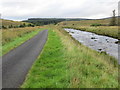
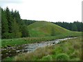
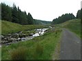
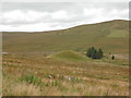
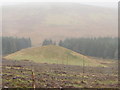
markj99 visited on 6th Jun 2021 - their rating: Cond: 2 Amb: 5 Access: 3 There is a minor unsigned turn off the A713 halfway between Dalmellington and Carsphairn at NX 51747 99760. It leads past Lamford Farm to a dead end in forestry beside the Water of Deugh. After c. 1 mile you will pass Lamford Burn cairn on the L. After another c. 0.5 miles take the L fork. After c. 1.5 miles there is a newly constructed road signed for Water of Deugh Circular on the L. After c. 0.2 miles there is a large lay-by on the R. Walk up the road c. 120 yards, looking R to see Brownhill Burn Cairn with a Spruce sapling growing in the middle of the cairn c. 50 yards W of the road.
")
Canmore ID 43497 has a full description of Brownhill Burn Cairn.
King's Cairn, a larger chambered cairn is only 400 yards NE of Brownhill Burn Cairn, hidden in a forest clearing.
You may be viewing yesterday's version of this page. To see the most up to date information please register for a free account.
")
")
")
")
Do not use the above information on other web sites or publications without permission of the contributor.
Nearby Images from Geograph Britain and Ireland:
©2017(licence)
©2007(licence)
©2007(licence)
©2016(licence)
©2012(licence)
The above images may not be of the site on this page, they are loaded from Geograph.
Please Submit an Image of this site or go out and take one for us!
Click here to see more info for this site
Nearby sites
Key: Red: member's photo, Blue: 3rd party photo, Yellow: other image, Green: no photo - please go there and take one, Grey: site destroyed
Download sites to:
KML (Google Earth)
GPX (GPS waypoints)
CSV (Garmin/Navman)
CSV (Excel)
To unlock full downloads you need to sign up as a Contributory Member. Otherwise downloads are limited to 50 sites.
Turn off the page maps and other distractions
Nearby sites listing. In the following links * = Image available
326m NE 38° Water of Deugh* Chambered Cairn (NS55420114)
2.9km SW 232° Lamford Burn* Cairn (NX52829916)
4.4km W 267° Cairnennock* Cairn (NS50800078)
4.9km SE 128° Gold Wells (Carsphairn) Holy Well or Sacred Spring (NX5896497793)
6.3km S 173° Green Well of Scotland (Carsphairn)* Holy Well or Sacred Spring (NX5573494565)
6.7km S 178° Holm Of Daltallochan Stone Circle* Stone Circle (NX55289422)
6.7km S 177° Holm of Daltallochan Standing Stone* Standing Stone (Menhir) (NX55399420)
7.0km S 171° Lagwine* Cairn (NX56069398)
8.4km NNW 343° Beoch Stone Circle Stone Circle (NS530090)
8.5km W 267° White Laise* Cairn (NS46730071)
8.5km S 173° Cairn Avel* Cairn (NX55949245)
9.2km N 351° Nith Lodge Stone Circle (NS540100)
9.8km E 96° Mungo's Well (Carsphairn) Holy Well or Sacred Spring (NX6492799555)
9.8km SSE 169° Bardennoch* Cairn (NX56859120)
9.8km SE 129° Craigengillan* Cairn (NX62699448)
10.2km SSE 168° Braidenoch Cross Slabs* Early Christian Sculptured Stone (NX57099081)
10.7km E 99° Nether Holm Of Dalquhairn* Cairn (NX65729892)
10.7km SSW 204° King's Well (Carsphairn) Holy Well or Sacred Spring (NX5043591268)
10.7km SSW 205° King's Stone (Carsphairn) Natural Stone / Erratic / Other Natural Feature (NX50419127)
11.8km SE 126° Round Craigs* Cairn (NX64519355)
12.2km SE 136° Smittons Bridge* Cairn (NX63409188)
12.2km SE 134° Stroanfreggan Craig* Hillfort (NX63709206)
12.6km SE 128° Chalybeate Well (Dalry)* Holy Well or Sacred Spring (NX6488792815)
12.9km SE 135° Stroanfreggan Cairn* Cairn (NX64019142)
13.4km S 174° Physic Well (Kells) Holy Well or Sacred Spring (NX5622587525)
View more nearby sites and additional images


 We would like to know more about this location. Please feel free to add a brief description and any relevant information in your own language.
 Wir möchten mehr über diese Stätte erfahren. Bitte zögern Sie nicht, eine kurze Beschreibung und relevante Informationen in Deutsch hinzuzufügen.
 Nous aimerions en savoir encore un peu sur les lieux. S'il vous plaît n'hesitez pas à ajouter une courte description et tous les renseignements pertinents dans votre propre langue.
 Quisieramos informarnos un poco más de las lugares. No dude en añadir una breve descripción y otros datos relevantes en su propio idioma.