 with our Megalithic Portal iPhone app")

<< Our Photo Pages >> Stroanfreggan Craig - Hillfort in Scotland in Dumfries and Galloway
Submitted by markj99 on Friday, 15 April 2022 Page Views: 639
Iron Age and Later PrehistorySite Name: Stroanfreggan CraigCountry: Scotland County: Dumfries and Galloway Type: Hillfort
Nearest Town: St John's Town of Dalry Nearest Village: Carsphairn
Map Ref: NX63709206
Latitude: 55.203933N Longitude: 4.143264W
Condition:
| 5 | Perfect |
| 4 | Almost Perfect |
| 3 | Reasonable but with some damage |
| 2 | Ruined but still recognisable as an ancient site |
| 1 | Pretty much destroyed, possibly visible as crop marks |
| 0 | No data. |
| -1 | Completely destroyed |
| 5 | Superb |
| 4 | Good |
| 3 | Ordinary |
| 2 | Not Good |
| 1 | Awful |
| 0 | No data. |
| 5 | Can be driven to, probably with disabled access |
| 4 | Short walk on a footpath |
| 3 | Requiring a bit more of a walk |
| 2 | A long walk |
| 1 | In the middle of nowhere, a nightmare to find |
| 0 | No data. |
| 5 | co-ordinates taken by GPS or official recorded co-ordinates |
| 4 | co-ordinates scaled from a detailed map |
| 3 | co-ordinates scaled from a bad map |
| 2 | co-ordinates of the nearest village |
| 1 | co-ordinates of the nearest town |
| 0 | no data |
Internal Links:
External Links:
I have visited· I would like to visit
markj99 visited on 11th Apr 2022 - their rating: Cond: 2 Amb: 4 Access: 4 There is a signed path beside an extended lay-by at NX 63413 91837 on the B729 c. 0.5 miles W of Stroanfreggan. After c. 300 yards on the NW path turn W towards the obvious summit with a modern cairn on top.
")
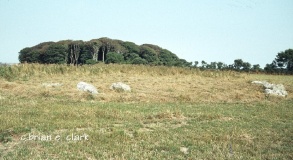
Stroanfreggan Craig Hillfort was an Iron Age fort on a ridge rising from the B729 c. 0.5 mile WNW of Stroanfreggan hamlet. The ruined hillfort enclosed c. 0.5 Acres on a lower summit of Stroanfreggan Craig. There is an extensive spread of stones on the N and W flanks, remains of a double wall enclosure according to Canmore ID 64376. The S flank is protected by a steep slope with a possible entrance to the fort up a natural gully. There is also a possible entrance on the E flank via a SE path. The rocky interior is featureless except for a linear scatter of stones in the N quadrant and a modern cairn marker in the centre of the enclosure.
You may be viewing yesterday's version of this page. To see the most up to date information please register for a free account.
")
")
")
")
")
")
")
")
")
")
")
")
Do not use the above information on other web sites or publications without permission of the contributor.
Click here to see more info for this site
Nearby sites
Key: Red: member's photo, Blue: 3rd party photo, Yellow: other image, Green: no photo - please go there and take one, Grey: site destroyed
Download sites to:
KML (Google Earth)
GPX (GPS waypoints)
CSV (Garmin/Navman)
CSV (Excel)
To unlock full downloads you need to sign up as a Contributory Member. Otherwise downloads are limited to 50 sites.
Turn off the page maps and other distractions
Nearby sites listing. In the following links * = Image available
349m WSW 237° Smittons Bridge* Cairn (NX63409188)
710m SSE 152° Stroanfreggan Cairn* Cairn (NX64019142)
1.4km NE 56° Chalybeate Well (Dalry)* Holy Well or Sacred Spring (NX6488792815)
1.7km NNE 27° Round Craigs* Cairn (NX64519355)
2.5km ENE 70° Stellhead S* Cairn (NX66059285)
2.5km ENE 67° Stellhead N* Cairn (NX66089297)
5.5km SSW 197° Mackilston N* Cairn (NX61968682)
5.6km SSW 196° Mackilston S* Cairn (NX61968678)
6.7km WSW 258° Braidenoch Cross Slabs* Early Christian Sculptured Stone (NX57099081)
6.9km W 261° Bardennoch* Cairn (NX56859120)
7.0km SW 221° Stroangassel Stone Circle (NX589869)
7.4km NW 319° Gold Wells (Carsphairn) Holy Well or Sacred Spring (NX5896497793)
7.6km N 8° Mungo's Well (Carsphairn) Holy Well or Sacred Spring (NX6492799555)
7.7km W 271° Cairn Avel* Cairn (NX55949245)
8.3km WNW 286° Green Well of Scotland (Carsphairn)* Holy Well or Sacred Spring (NX5573494565)
8.6km WNW 283° Holm of Daltallochan Standing Stone* Standing Stone (Menhir) (NX55399420)
8.7km WNW 283° Holm Of Daltallochan Stone Circle* Stone Circle (NX55289422)
8.7km WSW 237° Physic Well (Kells) Holy Well or Sacred Spring (NX5622587525)
9.4km SE 136° Spa Well (Dalry) Holy Well or Sacred Spring (NX7009385098)
9.8km SSE 151° Corriedoo* Cairn (NX6814083327)
10.2km ESE 118° Hole Stone (Blackmark)* Standing Stone (Menhir) (NX72568698)
12.0km ENE 74° St. Conal's Well* Holy Well or Sacred Spring (NX75399508)
12.1km ESE 115° Physic Well (Balmaclellan) Holy Well or Sacred Spring (NX7452586502)
12.2km NW 314° Brownhill Burn* Cairn (NS55210089)
12.3km NW 316° Water of Deugh* Chambered Cairn (NS55420114)
View more nearby sites and additional images


 We would like to know more about this location. Please feel free to add a brief description and any relevant information in your own language.
 Wir möchten mehr über diese Stätte erfahren. Bitte zögern Sie nicht, eine kurze Beschreibung und relevante Informationen in Deutsch hinzuzufügen.
 Nous aimerions en savoir encore un peu sur les lieux. S'il vous plaît n'hesitez pas à ajouter une courte description et tous les renseignements pertinents dans votre propre langue.
 Quisieramos informarnos un poco más de las lugares. No dude en añadir una breve descripción y otros datos relevantes en su propio idioma.