


<< Our Photo Pages >> Lamford Burn - Cairn in Scotland in Dumfries and Galloway
Submitted by PaulM on Sunday, 29 December 2002 Page Views: 4747
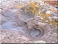
Neolithic and Bronze AgeSite Name: Lamford BurnCountry: Scotland County: Dumfries and Galloway Type: Cairn
Nearest Village: Drumjohn
Map Ref: NX52829916 Landranger Map Number: 77
Latitude: 55.264558N Longitude: 4.31778W
Condition:
| 5 | Perfect |
| 4 | Almost Perfect |
| 3 | Reasonable but with some damage |
| 2 | Ruined but still recognisable as an ancient site |
| 1 | Pretty much destroyed, possibly visible as crop marks |
| 0 | No data. |
| -1 | Completely destroyed |
| 5 | Superb |
| 4 | Good |
| 3 | Ordinary |
| 2 | Not Good |
| 1 | Awful |
| 0 | No data. |
| 5 | Can be driven to, probably with disabled access |
| 4 | Short walk on a footpath |
| 3 | Requiring a bit more of a walk |
| 2 | A long walk |
| 1 | In the middle of nowhere, a nightmare to find |
| 0 | No data. |
| 5 | co-ordinates taken by GPS or official recorded co-ordinates |
| 4 | co-ordinates scaled from a detailed map |
| 3 | co-ordinates scaled from a bad map |
| 2 | co-ordinates of the nearest village |
| 1 | co-ordinates of the nearest town |
| 0 | no data |
Internal Links:
External Links:
I have visited· I would like to visit
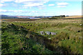
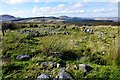
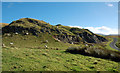
markj99 visited on 6th Jun 2021 - their rating: Cond: 2 Amb: 3 Access: 4 The low lying remains of Lamford Burn Cairn are not overly impressive however it is possible to view the footprint of a substantial cairn. Parking is available on the verge directly beside the cairn. Easy to visit if heading for Brownhill Burn & Water of Deugh Cairns.
")
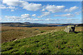
Lamford Burn cairn Another inclusion in the regions’ Archaeosights leaflet - this laneside cairn is typical of many in the region. Located at NX52829915 the stone built cairn is enclosed behind a wire fence but has spectacular views over the surrounding mountains.
You may be viewing yesterday's version of this page. To see the most up to date information please register for a free account.
")
")
Do not use the above information on other web sites or publications without permission of the contributor.
Nearby Images from Geograph Britain and Ireland:
©2016(licence)
©2016(licence)
©2016(licence)
©2016(licence)
©2007(licence)
The above images may not be of the site on this page, they are loaded from Geograph.
Please Submit an Image of this site or go out and take one for us!
Click here to see more info for this site
Nearby sites
Key: Red: member's photo, Blue: 3rd party photo, Yellow: other image, Green: no photo - please go there and take one, Grey: site destroyed
Download sites to:
KML (Google Earth)
GPX (GPS waypoints)
CSV (Garmin/Navman)
CSV (Excel)
To unlock full downloads you need to sign up as a Contributory Member. Otherwise downloads are limited to 50 sites.
Turn off the page maps and other distractions
Nearby sites listing. In the following links * = Image available
2.6km NW 307° Cairnennock Cairn (NS50800078)
2.9km NE 52° Brownhill Burn* Cairn (NS55210089)
3.3km NE 51° Water of Deugh* Chambered Cairn (NS55420114)
5.4km SE 146° Green Well of Scotland (Carsphairn)* Holy Well or Sacred Spring (NX5573494565)
5.5km SSE 152° Holm Of Daltallochan Stone Circle* Stone Circle (NX55289422)
5.6km SSE 151° Holm of Daltallochan Standing Stone* Standing Stone (Menhir) (NX55399420)
6.3km E 101° Gold Wells (Carsphairn) Holy Well or Sacred Spring (NX5896497793)
7.4km SSE 153° Cairn Avel* Cairn (NX55949245)
8.2km SSW 195° King's Well (Carsphairn) Holy Well or Sacred Spring (NX5043591268)
8.2km SSW 195° King's Stone (Carsphairn) Natural Stone / Erratic / Other Natural Feature (NX50419127)
8.9km SSE 151° Bardennoch* Cairn (NX56859120)
9.4km SSE 151° Braidenoch Cross Slabs* Early Christian Sculptured Stone (NX57099081)
9.8km N 359° Beoch Stone Circle Stone Circle (NS530090)
10.9km N 4° Nith Lodge Stone Circle (NS540100)
12.1km E 86° Mungo's Well (Carsphairn) Holy Well or Sacred Spring (NX6492799555)
12.1km SSE 162° Physic Well (Kells) Holy Well or Sacred Spring (NX5622587525)
12.3km WSW 237° Moss Knowes* Natural Stone / Erratic / Other Natural Feature (NX42239281)
12.4km W 263° Cairnwhapple Stone* Natural Stone / Erratic / Other Natural Feature (NX40399796)
12.8km ESE 123° Smittons Bridge* Cairn (NX63409188)
12.9km ESE 114° Round Craigs* Cairn (NX64519355)
13.0km ESE 121° Stroanfreggan Craig* Hillfort (NX63709206)
13.6km ESE 123° Stroanfreggan Cairn* Cairn (NX64019142)
13.6km ESE 116° Chalybeate Well (Dalry)* Holy Well or Sacred Spring (NX6488792815)
13.7km SSE 152° Stroangassel Stone Circle (NX589869)
14.6km ESE 113° Stellhead N* Cairn (NX66089297)
View more nearby sites and additional images


 We would like to know more about this location. Please feel free to add a brief description and any relevant information in your own language.
 Wir möchten mehr über diese Stätte erfahren. Bitte zögern Sie nicht, eine kurze Beschreibung und relevante Informationen in Deutsch hinzuzufügen.
 Nous aimerions en savoir encore un peu sur les lieux. S'il vous plaît n'hesitez pas à ajouter une courte description et tous les renseignements pertinents dans votre propre langue.
 Quisieramos informarnos un poco más de las lugares. No dude en añadir una breve descripción y otros datos relevantes en su propio idioma.