<< Our Photo Pages >> Dinas Gynfor - Hillfort in Wales in Anglesey
Submitted by vicky on Tuesday, 24 September 2002 Page Views: 16931
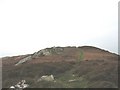
Iron Age and Later PrehistorySite Name: Dinas GynforCountry: Wales
NOTE: This site is 55.8 km away from the location you searched for.
County: Anglesey Type: Hillfort
Nearest Village: Llanbadrig
Map Ref: SH391951 Landranger Map Number: 114
Latitude: 53.428071N Longitude: 4.423165W
Condition:
| 5 | Perfect |
| 4 | Almost Perfect |
| 3 | Reasonable but with some damage |
| 2 | Ruined but still recognisable as an ancient site |
| 1 | Pretty much destroyed, possibly visible as crop marks |
| 0 | No data. |
| -1 | Completely destroyed |
| 5 | Superb |
| 4 | Good |
| 3 | Ordinary |
| 2 | Not Good |
| 1 | Awful |
| 0 | No data. |
| 5 | Can be driven to, probably with disabled access |
| 4 | Short walk on a footpath |
| 3 | Requiring a bit more of a walk |
| 2 | A long walk |
| 1 | In the middle of nowhere, a nightmare to find |
| 0 | No data. |
| 5 | co-ordinates taken by GPS or official recorded co-ordinates |
| 4 | co-ordinates scaled from a detailed map |
| 3 | co-ordinates scaled from a bad map |
| 2 | co-ordinates of the nearest village |
| 1 | co-ordinates of the nearest town |
| 0 | no data |
Internal Links:
External Links:
I have visited· I would like to visit
cactus_chris visited on 16th May 2019 Seen only from the other headland on the Anglesey Coastal Path.
PAB have visited here
")
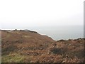
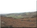
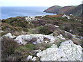
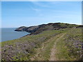
Defended naturally by cliffs on three sides and a double row of wall to the south, this fort has lovely views out to the Irish Sea.
Have you visited this site? Please add a comment below.
You may be viewing yesterday's version of this page. To see the most up to date information please register for a free account.
")
")
")
")
Do not use the above information on other web sites or publications without permission of the contributor.
Nearby Images from Geograph Britain and Ireland:
©2009(licence)
©2009(licence)
©2013(licence)
©2014(licence)
©2009(licence)
The above images may not be of the site on this page, they are loaded from Geograph.
Please Submit an Image of this site or go out and take one for us!
Click here to see more info for this site
Nearby sites
Key: Red: member's photo, Blue: 3rd party photo, Yellow: other image, Green: no photo - please go there and take one, Grey: site destroyed
Download sites to:
KML (Google Earth)
GPX (GPS waypoints)
CSV (Garmin/Navman)
CSV (Excel)
To unlock full downloads you need to sign up as a Contributory Member. Otherwise downloads are limited to 50 sites.
Turn off the page maps and other distractions
Nearby sites listing. In the following links * = Image available
1.6km WSW 250° Ichthus Stone* Early Christian Sculptured Stone (SH376946)
3.3km SE 131° Werthyr* Standing Stone (Menhir) (SH4152292868)
4.0km SSW 209° Llanfechell 2* Standing Stone (Menhir) (SH3699291640)
4.3km SW 223° Foel Fawr (Anglesey)* Chambered Tomb (SH3604692003)
4.3km SW 216° Llanfechell 1* Standing Stones (SH3639791688)
5.1km SSE 161° Bodewryd* Standing Stone (Menhir) (SH406902)
5.5km SW 227° Caerdegog Uchaf* Modern Stone Circle etc (SH349915)
5.6km S 174° Maen y Goges* Natural Stone / Erratic / Other Natural Feature (SH39518948)
7.1km SE 129° Parys Mountain* Ancient Mine, Quarry or other Industry (SH445905)
7.2km SW 230° Pen yr Orsedd 2* Standing Stone (Menhir) (SH33399062)
7.4km SW 229° Pen Yr Orsedd* Standing Stone (Menhir) (SH3334190391)
7.5km E 101° Porth Newydd* Natural Stone / Erratic / Other Natural Feature (SH46449341)
7.7km ESE 102° St Eilian's Well* Holy Well or Sacred Spring (SH46569329)
8.1km S 187° St Pabo's Church Memorial Stone* Early Christian Sculptured Stone (SH378871)
8.1km ESE 104° St Eilian (Llaneilian)* Ancient Cross (SH46949288)
9.6km SSW 192° Bod Deiniol* Standing Stone (Menhir) (SH3683285739)
10.0km SSE 155° Bryn Dyfrydog* Standing Stone (Menhir) (SH431859)
10.2km SSE 154° Maen Chwyf* Natural Stone / Erratic / Other Natural Feature (SH43268574)
10.4km WSW 249° Ynys-y-Fydlyn* Promontory Fort / Cliff Castle (SH29189175)
10.5km SSW 194° Bedd Branwen* Ring Cairn (SH3611184978)
10.6km WSW 244° Rhoscryman Cairn* Cairn (SH29479072)
11.1km SSW 205° Llynnon Mill and Iron Age Settlement* Museum (SH340852)
11.2km SSE 159° Bedd y Foel* Burial Chamber or Dolmen (SH42698444)
11.3km SW 217° Soar Stone* Standing Stone (Menhir) (SH3192286327)
11.6km SSE 155° Llwydiarth Esgob Stone* Rock Art (SH436844)
View more nearby sites and additional images


 We would like to know more about this location. Please feel free to add a brief description and any relevant information in your own language.
 Wir möchten mehr über diese Stätte erfahren. Bitte zögern Sie nicht, eine kurze Beschreibung und relevante Informationen in Deutsch hinzuzufügen.
 Nous aimerions en savoir encore un peu sur les lieux. S'il vous plaît n'hesitez pas à ajouter une courte description et tous les renseignements pertinents dans votre propre langue.
 Quisieramos informarnos un poco más de las lugares. No dude en añadir una breve descripción y otros datos relevantes en su propio idioma.