<< Our Photo Pages >> Rhoscryman Cairn - Cairn in Wales in Anglesey
Submitted by pab on Tuesday, 25 September 2012 Page Views: 3881
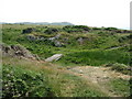
Neolithic and Bronze AgeSite Name: Rhoscryman CairnCountry: Wales County: Anglesey Type: Cairn
Map Ref: SH29479072
Latitude: 53.385713N Longitude: 4.565581W
Condition:
| 5 | Perfect |
| 4 | Almost Perfect |
| 3 | Reasonable but with some damage |
| 2 | Ruined but still recognisable as an ancient site |
| 1 | Pretty much destroyed, possibly visible as crop marks |
| 0 | No data. |
| -1 | Completely destroyed |
| 5 | Superb |
| 4 | Good |
| 3 | Ordinary |
| 2 | Not Good |
| 1 | Awful |
| 0 | No data. |
| 5 | Can be driven to, probably with disabled access |
| 4 | Short walk on a footpath |
| 3 | Requiring a bit more of a walk |
| 2 | A long walk |
| 1 | In the middle of nowhere, a nightmare to find |
| 0 | No data. |
| 5 | co-ordinates taken by GPS or official recorded co-ordinates |
| 4 | co-ordinates scaled from a detailed map |
| 3 | co-ordinates scaled from a bad map |
| 2 | co-ordinates of the nearest village |
| 1 | co-ordinates of the nearest town |
| 0 | no data |
Internal Links:
External Links:
I have visited· I would like to visit
PAB has visited here
")
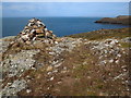
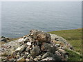
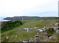
Identified on 25K OS Maps, but not 50K, this cairn is located on a headland on the western coast of Anglesey - Dublin being just over 60 miles due west.
The cairn has a fair covering of lichen etc, with only a few stones having the appearance of recent deposit by walkers etc, but I have not been able to find any robust confirmation of antiquity. As with so many of these sites of course, it is important to remember that absence of any proof of antiquity is not the same as proof that a site isn't ancient!
No mention on COFLEIN - underlying ground makes it very unlikely that there would have been a cist confirming a burial purpose, but a great marker for anyone looking for the relatively safe landing on beaches nearby.
You may be viewing yesterday's version of this page. To see the most up to date information please register for a free account.
")
")
")
Do not use the above information on other web sites or publications without permission of the contributor.
Nearby Images from Geograph Britain and Ireland:
©2019(licence)
©2009(licence)
©2009(licence)
©2016(licence)
©2009(licence)
The above images may not be of the site on this page, they are loaded from Geograph.
Please Submit an Image of this site or go out and take one for us!
Click here to see more info for this site
Nearby sites
Key: Red: member's photo, Blue: 3rd party photo, Yellow: other image, Green: no photo - please go there and take one, Grey: site destroyed
Download sites to:
KML (Google Earth)
GPX (GPS waypoints)
CSV (Garmin/Navman)
CSV (Excel)
To unlock full downloads you need to sign up as a Contributory Member. Otherwise downloads are limited to 50 sites.
Turn off the page maps and other distractions
Nearby sites listing. In the following links * = Image available
1.1km NNW 342° Ynys-y-Fydlyn* Promontory Fort / Cliff Castle (SH29189175)
3.9km E 93° Pen Yr Orsedd* Standing Stone (Menhir) (SH3334190391)
3.9km E 89° Pen yr Orsedd 2* Standing Stone (Menhir) (SH33399062)
5.0km SSE 149° Soar Stone* Standing Stone (Menhir) (SH3192286327)
5.5km E 80° Caerdegog Uchaf* Modern Stone Circle etc (SH349915)
6.7km ENE 77° Foel Fawr (Anglesey)* Chambered Tomb (SH3604692003)
7.0km E 80° Llanfechell 1* Standing Stones (SH3639791688)
7.1km SE 139° Llynnon Mill and Iron Age Settlement* Museum (SH340852)
7.6km E 81° Llanfechell 2* Standing Stone (Menhir) (SH3699291640)
8.8km SE 129° Bedd Branwen* Ring Cairn (SH3611184978)
8.8km SSE 147° Tre-Gwehelydd* Standing Stone (Menhir) (SH34068318)
8.9km ESE 122° Bod Deiniol* Standing Stone (Menhir) (SH3683285739)
9.0km ENE 62° Ichthus Stone* Early Christian Sculptured Stone (SH376946)
9.1km ESE 111° St Pabo's Church Memorial Stone* Early Christian Sculptured Stone (SH378871)
9.2km SW 219° Stones near Holyhead breakwater* Natural Stone / Erratic / Other Natural Feature (SH2340583806)
9.3km SSW 195° Penrhos (Holyhead)* Standing Stone (Menhir) (SH26828183)
9.4km SSW 208° Caer Gybi Roman Fort* Stone Fort or Dun (SH2471882615)
9.8km SSE 164° Shop Farm* Standing Stone (Menhir) (SH3180581223)
9.8km SE 134° New Church* Standing Stone (Menhir) (SH363837)
10.1km E 95° Maen y Goges* Natural Stone / Erratic / Other Natural Feature (SH39518948)
10.6km ENE 63° Dinas Gynfor* Hillfort (SH391951)
10.6km SSW 201° Ty Mawr (Nr Holyhead)* Standing Stone (Menhir) (SH2539480951)
10.8km SSW 198° Trefignath* Chambered Tomb (SH25858056)
10.9km SW 223° Caer y Twr* Hillfort (SH218830)
10.9km SSW 194° Trearddur Dolmen* Burial Chamber or Dolmen (SH264802)
View more nearby sites and additional images


 We would like to know more about this location. Please feel free to add a brief description and any relevant information in your own language.
 Wir möchten mehr über diese Stätte erfahren. Bitte zögern Sie nicht, eine kurze Beschreibung und relevante Informationen in Deutsch hinzuzufügen.
 Nous aimerions en savoir encore un peu sur les lieux. S'il vous plaît n'hesitez pas à ajouter une courte description et tous les renseignements pertinents dans votre propre langue.
 Quisieramos informarnos un poco más de las lugares. No dude en añadir una breve descripción y otros datos relevantes en su propio idioma.