<< Our Photo Pages >> Shop Farm - Standing Stone (Menhir) in Wales in Anglesey
Submitted by TimPrevett on Wednesday, 25 September 2002 Page Views: 5523
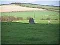
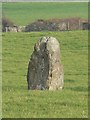
Neolithic and Bronze AgeSite Name: Shop FarmCountry: Wales County: Anglesey Type: Standing Stone (Menhir)
Map Ref: SH3180581223 Landranger Map Number: 114
Latitude: 53.301180N Longitude: 4.525462W
Condition:
| 5 | Perfect |
| 4 | Almost Perfect |
| 3 | Reasonable but with some damage |
| 2 | Ruined but still recognisable as an ancient site |
| 1 | Pretty much destroyed, possibly visible as crop marks |
| 0 | No data. |
| -1 | Completely destroyed |
| 5 | Superb |
| 4 | Good |
| 3 | Ordinary |
| 2 | Not Good |
| 1 | Awful |
| 0 | No data. |
| 5 | Can be driven to, probably with disabled access |
| 4 | Short walk on a footpath |
| 3 | Requiring a bit more of a walk |
| 2 | A long walk |
| 1 | In the middle of nowhere, a nightmare to find |
| 0 | No data. |
| 5 | co-ordinates taken by GPS or official recorded co-ordinates |
| 4 | co-ordinates scaled from a detailed map |
| 3 | co-ordinates scaled from a bad map |
| 2 | co-ordinates of the nearest village |
| 1 | co-ordinates of the nearest town |
| 0 | no data |
Internal Links:
External Links:
I have visited· I would like to visit
TimPrevett has visited here
")
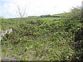
Access: Park off the A5025 Valley to Cemaes road. I had to go through a farm, so I knocked and asked permission, and was granted it very cheerfully. The field was high in thistles in places, and quite spikey. It was also a silage field, so crap was everywhere. The stone: Relatively small - about 5 feet. Couldn't see much detail on it, as it was sprayed with silage, and iced with bird poo.
Note: Permission should be sought from the nearby farm before visiting.
You may be viewing yesterday's version of this page. To see the most up to date information please register for a free account.
")
")
")
Do not use the above information on other web sites or publications without permission of the contributor.
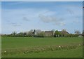
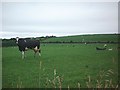
Nearby Images from Geograph Britain and Ireland:
©2008(licence)
©2006(licence)
©2009(licence)
©2005(licence)
©2009(licence)
The above images may not be of the site on this page, they are loaded from Geograph.
Please Submit an Image of this site or go out and take one for us!
Click here to see more info for this site
Nearby sites
Key: Red: member's photo, Blue: 3rd party photo, Yellow: other image, Green: no photo - please go there and take one, Grey: site destroyed
Download sites to:
KML (Google Earth)
GPX (GPS waypoints)
CSV (Garmin/Navman)
CSV (Excel)
To unlock full downloads you need to sign up as a Contributory Member. Otherwise downloads are limited to 50 sites.
Turn off the page maps and other distractions
Nearby sites listing. In the following links * = Image available
3.0km E 94° Presaddfed* Chambered Tomb (SH34768089)
3.0km NE 47° Tre-Gwehelydd* Standing Stone (Menhir) (SH34068318)
4.5km NNE 27° Llynnon Mill and Iron Age Settlement* Museum (SH340852)
4.8km WSW 239° Ynys Leurad* Ancient Village or Settlement (SH2764978895)
4.9km SSW 192° Llyn Cerrig Bach* Natural Stone / Erratic / Other Natural Feature (SH30607650)
5.0km W 275° Penrhos (Holyhead)* Standing Stone (Menhir) (SH26828183)
5.1km N 359° Soar Stone* Standing Stone (Menhir) (SH3192286327)
5.1km ENE 59° New Church* Standing Stone (Menhir) (SH363837)
5.5km WSW 257° Trearddur Dolmen* Burial Chamber or Dolmen (SH264802)
5.6km WSW 243° Trearddur standing stone* Standing Stone (Menhir) (SH267788)
5.7km NE 47° Bedd Branwen* Ring Cairn (SH3611184978)
5.9km SW 222° Bodior Standing Stone* Standing Stone (Menhir) (SH277770)
6.0km W 262° Trefignath* Chambered Tomb (SH25858056)
6.3km E 89° Maen Llechgynfarwy* Standing Stone (Menhir) (SH38108116)
6.4km W 266° Ty Mawr (Nr Holyhead)* Standing Stone (Menhir) (SH2539480951)
6.7km NE 46° Bod Deiniol* Standing Stone (Menhir) (SH3683285739)
7.1km SW 228° Cromlech in Rhoscolyn* Burial Chamber or Dolmen (SH2634376610)
7.2km W 279° Caer Gybi Roman Fort* Stone Fort or Dun (SH2471882615)
7.6km SW 215° Borthwen Beach* Chambered Tomb (SH2714975151)
7.7km SSE 149° Bodfeddan Inscribed Stone* Standing Stone (Menhir) (SH356745)
7.7km SW 228° Bwa Gwyn* Natural Stone / Erratic / Other Natural Feature (SH259762)
7.8km SSE 158° Ty Newydd (Llanfaelog)* Chambered Tomb (SH34437387)
7.8km SW 216° Borth Wen Stone Row / Alignment (SH27007500)
7.9km W 266° Carreg y Bwgan* Natural Stone / Erratic / Other Natural Feature (SH2390380891)
8.0km SE 130° A55 Erratic* Natural Stone / Erratic / Other Natural Feature (SH3774475886)
View more nearby sites and additional images


 We would like to know more about this location. Please feel free to add a brief description and any relevant information in your own language.
 Wir möchten mehr über diese Stätte erfahren. Bitte zögern Sie nicht, eine kurze Beschreibung und relevante Informationen in Deutsch hinzuzufügen.
 Nous aimerions en savoir encore un peu sur les lieux. S'il vous plaît n'hesitez pas à ajouter une courte description et tous les renseignements pertinents dans votre propre langue.
 Quisieramos informarnos un poco más de las lugares. No dude en añadir una breve descripción y otros datos relevantes en su propio idioma.