Featured: Ark of Secrets - Neolithic spirit alive in the Middle Ages

Ark of Secrets - Neolithic spirit alive in the Middle Ages

Hengeworld

Hengeworld

Who's Online

There are currently, 317 guests and 2 members online.

You are a guest. To join in, please register for free by clicking here

Sponsors

<< Text Pages >> Castle Feather - Promontory Fort / Cliff Castle in Scotland in Dumfries and Galloway

Submitted by Andy B on Monday, 30 August 2010  Page Views: 9895

Iron Age and Later PrehistorySite Name: Castle Feather Alternative Name: Port Castle, Carghidown, Tonderghie
Country: Scotland County: Dumfries and Galloway Type: Promontory Fort / Cliff Castle

Map Ref: NX449342
Latitude: 54.678909N  Longitude: 4.40714W
Condition:
5Perfect
4Almost Perfect
3Reasonable but with some damage
2Ruined but still recognisable as an ancient site
1Pretty much destroyed, possibly visible as crop marks
0No data.
-1Completely destroyed
2 Ambience:
5Superb
4Good
3Ordinary
2Not Good
1Awful
0No data.
5 Access:
5Can be driven to, probably with disabled access
4Short walk on a footpath
3Requiring a bit more of a walk
2A long walk
1In the middle of nowhere, a nightmare to find
0No data.
3 Accuracy:
5co-ordinates taken by GPS or official recorded co-ordinates
4co-ordinates scaled from a detailed map
3co-ordinates scaled from a bad map
2co-ordinates of the nearest village
1co-ordinates of the nearest town
0no data
4

Internal Links:
External Links:

Promontory Fort in Dumfries and Galloway

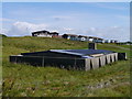
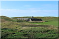
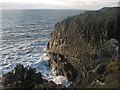
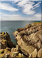
Castle Feather is a two period site, a promontory fort having subsequently been utilised for a medieval castle.

The medieval features comprise the internal structures, the largest of which has 4' thick walls and is presumably the tower-house, while the others are ancillary buildings and the revetting of the scarp of the inner ditch is stone.

The ramparts and ditches belong to the promontory fort, though they have subsequently been heavily mutilated. These defences seem to have comprised five earthen ramparts and ditches on the N side, and three on the S, but the central area is so disturbed that the relationship of these ramparts to one another is quite uncertain.

More at Scotland's Places

Also nearby are the prehistoric promontory forts at Port Castle, Carghidown and Tonderghie
You may be viewing yesterday's version of this page. To see the most up to date information please register for a free account.


Do not use the above information on other web sites or publications without permission of the contributor.

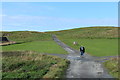
Nearby Images from Geograph Britain and Ireland:
NX4434 : Burrow Head: Old And New by James T M Towill
by James T M Towill
©2014(licence)
NX4434 : Old Building at Burrowhead Holiday Village by Billy McCrorie
by Billy McCrorie
©2015(licence)
NX4434 : Stank by Callum Black
by Callum Black
©2007(licence)
NX4434 : The Stank by Andy Farrington
by Andy Farrington
©2012(licence)
NX4434 : Path to St Ninian's Cave by Billy McCrorie
by Billy McCrorie
©2015(licence)

The above images may not be of the site on this page, they are loaded from Geograph.
Please Submit an Image of this site or go out and take one for us!


Click here to see more info for this site

Nearby sites

Click here to view sites on an interactive OS map

Key: Red: member's photo, Blue: 3rd party photo, Yellow: other image, Green: no photo - please go there and take one, Grey: site destroyed

Download sites to:
KML (Google Earth)
GPX (GPS waypoints)
CSV (Garmin/Navman)
CSV (Excel)

To unlock full downloads you need to sign up as a Contributory Member. Otherwise downloads are limited to 50 sites.


Turn off the page maps and other distractions

Nearby sites listing. In the following links * = Image available
 2.5km NNE 30° Drummoral Hillfort (NX462363)
 2.9km NNE 32° Leakin Hill Cup and Rings Rock Art (NX465366)
 3.2km WNW 301° St Ninian's Cave (Isle of Whithorn)* Early Christian Sculptured Stone (NX42243595)
 3.6km ENE 57° Isle Head* Promontory Fort / Cliff Castle (NX48033605)
 5.3km NW 305° Glasserton Mains* Rock Art (NX40613737)
 5.9km NNE 16° Little Balsmith* Standing Stone (Menhir) (NX4670539812)
 6.0km WNW 299° Laggan Camp* Hillfort (NX3976437252)
 6.0km N 354° Peter Hill Roundhouse (Whithorn)* Ancient Village or Settlement (NX4442440212)
 6.1km NNW 339° Rispain Camp* Ancient Village or Settlement (NX4293039930)
 6.1km N 354° Whithorn Museum* Museum (NX44494028)
 7.3km N 4° St Kiaran's Well (Chapelheron) Holy Well or Sacred Spring (NX456415)
 9.7km WNW 301° Boden Walls Well Holy Well or Sacred Spring (NX36773947)
 9.8km NW 304° Knock 5* Carving (NX36903995)
 10.1km WNW 303° Kirkmaiden Old Church* Ancient Cross (NX3655739968)
 10.3km WNW 303° St Medana's Well* Holy Well or Sacred Spring (NX36454005)
 10.3km WNW 303° Knock Rock Art (1)* Rock Art (NX36454012)
 10.3km NW 311° Blairbuy 2* Rock Art (NX37284117)
 10.5km NW 305° Knock Rock Art (4)* Rock Art (NX365405)
 10.5km NW 314° Blairbuy 5* Rock Art (NX37594175)
 10.5km NW 310° Blairbuy 1* Rock Art (NX371413)
 10.7km NW 314° Fell of Barhullion* Hillfort (NX37454188)
 10.9km NNW 332° White Loch. Crannog (NX40174404)
 11.0km NW 316° Blairbuy 3* Rock Art (NX37464233)
 11.2km NW 312° Blairbuy 4 Rock Art (NX368420)
 11.4km NW 308° Milton Hill* Standing Stones (NX36174159)
View more nearby sites and additional images

<< How Hill

Mead's Plantation >>

Please add your thoughts on this site

An Archaeology of Natural Places

An Archaeology of Natural Places

Sponsors

Auto-Translation (Google)

Translate from English into:

"Castle Feather" | Login/Create an Account | 3 News and Comments
  
Go back to top of page    Comments are owned by the poster. We aren't responsible for their content.
Copper mining at Tonderghie by Andy B on Sunday, 23 September 2012
(User Info | Send a Message)
What evidence is there for prospecting and mining for copper ores during the Bronze Age in Scotland? Some of the problems in identifying early metal mining sites are demonstrated by the site at Tonderghie, a small copper deposit near Whithorn, Dumfries and Galloway.

At Tonderghie a vein of barite with some copper mineralisation - mainly chalcopyrite and malachite - is exposed in coastal cliffs. This is one of a number of small copper deposits in south-west Scotland which were exploited during the post medieval period. Surviving surface remains, all assumed to be eighteenth or nineteenth century in date, include two in-filled mine shafts, a collapsed adit level and some areas of spoil. There is also an undated opencast working on the vein itself. Some of the mine workings overlay an area of rig cultivation.

Tonderghie is unique in having strong circumstantial evidence for earlier, possibly prehistoric, phases of mining. The Old Statistical Account of Whithorn parish compiled in 1794 refers to 'six pieces (of copper) in an earthen vessel' found on the Tonderghie estate and an accompanying illustration of one of these objects indicates that this was a hoard of EBA copper ingots. The same account also describes the discovery on the estate of a circular copper ingot which by its size and weight appears to be a late prehistoric or Roman bun ingot. Another bun ingot was found in 1880 at Carleton some 5km north west of Tonderghie. These ingots suggest the exploitation of a local ore source and Tonderghie, as the only copper vein in the immediate area, is the most likely site.

Recent fieldwork (Pickin and Hunter 2008) at Tonderghie has attempted to identify evidence for early exploitation. Over the last thirty years a number of Bronze Age mines have been recognised and recorded in Ireland, Wales and England. All these mines have produced a range of distinctive stone tools which were used in hard rock mining and ore processing; these tools are often found in association with mine spoil and fire-setting residues. Despite detailed searches on a number of occasions no stone tools have been found at Tonderghie nor have any stone tools from the site been identified in local museum collections. A detailed topographical survey by RCAHMS recorded the post-medieval mining features and the earlier, but probably still post medieval, field system.

The survey also recorded some enigmatic earthworks, possibly related to ore extraction and processing, but their relationship to the field system and later mining features could not be established. Geophysical survey of the same area highlighted several features of archaeological significance including a feature close to the opencast interpreted as a circular ditched enclosure and the traces of another circular structure or hollowed feature, defined by a stone bank or wall, overlain by one of the post medieval mine shafts. Both the topographical and geophysical surveys suggest activity at the site predating the post medieval field system but further interpretation and dating can only be achieved through archaeological excavation.

Read more at
http://www.scottishheritagehub.com/content/case-study-copper-mining-tonderghie
[ Reply to This ]

Re: Ninian’s Cave to the Isle of Whithorn, Saturday 17th September 2011 by Andy B on Sunday, 28 August 2011
(User Info | Send a Message)
Ninian’s Cave to the Isle of Whithorn

Region:Dumfries and Galloway
Saturday 18th September, 11.30am - 4pm
Location:
Meet at Physgill Glen car park

A coastal walk, from Ninian’s Cave, via the prehistoric promontory forts at Port Castle, Carghidown, Tonderghie and Castle Feather, and the 18th century Mary Mine at Tonderghie, to Burrow Head, site of three more forts and a WW2 Anti-Aircraft Training Battery and on to the chapel and fort at the Isle of Whithorn. 6.5 miles, moderate grade. Stout footwear advisable.

Contact:
Andrew Nicholson
Dumfries and Galloway Council
01387 260154
andrew.nicholson@dumgal.gov.uk
http://www.dumgal.gov.uk

Scottish Archaeology Month 2011
[ Reply to This ]

Archaeologists battle to save promontory fort in Galloway by Andy B on Monday, 30 August 2010
(User Info | Send a Message)
Story from 27 October 2003:
ARCHAEOLOGISTS are engaged in a race to save the remnants of an Iron Age settlement built by one of the most mysterious early peoples of Scotland. The prehistoric site at Carghidown, near the Isle of Whithorn, Galloway, could illuminate the lives of an ancient tribe called the Novantae.

However, the promontory fort located 100ft above the sea, which has a number of extremely rare features, faces destruction after years of wave and wind action and could collapse into the sea. Evidence from the floors of dwellings at the settlement will be used todocument the daily lives of the little known tribe, which lived in south-west Scotland.

A number of lead beads discovered at Carghidown also indicates the inhabitants enjoyed more sophisticated trading networks than previously believed. Ronan Toolis, project officer for AOC Archaeology, led the excavation. He said: "Carghidown is an enigmatic site. While it was probably occupied in the Iron Age, we don't yet know exactly when it was occupied.

"There is no access to the sea and, although it is called a fort, it wasn't a defensive position as a hill overlooks the site. However, if we don't get back soon it is very likely that more archaeology will be lost to the sea."

Two roundhouses were discovered within the promontory fort, defined by dry stone walls, one of which contained a series of floor deposits, which is uncommon in archaeological sites as floors have often been ploughed away.

The three rare lead beads were recovered from just outside one of the roundhouses and are believed to have been part of some intricate form of jewellery. Archaeologists have found little evidence for the lives of the Novantae before the Roman Conquest.

They were thought to have replaced a small, dark-haired aboriginal race, probably akin to Basques of the Iberian peninsula, who held this south-western corner of Scotland for centuries. The Novantae were farmers and herders, but few of their farms and other settlements have been excavated by archaeologists so far.

Mr Toolis said: "We hope to return next year to excavate the site, in order to shed new light on how and why the Iron Age people of Galloway chose to occupy coastal sites like Carghidown."

Source: The Herald
[ Reply to This ]

Your Name: Anonymous [ Register Now ]
Subject:


Add your comment or contribution to this page. Spam or offensive posts are deleted immediately, don't even bother

<<< What is five plus one as a number? (Please type the answer to this question in the little box on the left)
You can also embed videos and other things. For Youtube please copy and paste the 'embed code'.
For Google Street View please include Street View in the text.
Create a web link like this: <a href="https://www.megalithic.co.uk">This is a link</a>  

Allowed HTML is:
<p> <b> <i> <a> <img> <em> <br> <strong> <blockquote> <tt> <li> <ol> <ul> <object> <param> <embed> <iframe>

We would like to know more about this location. Please feel free to add a brief description and any relevant information in your own language.
Wir möchten mehr über diese Stätte erfahren. Bitte zögern Sie nicht, eine kurze Beschreibung und relevante Informationen in Deutsch hinzuzufügen.
Nous aimerions en savoir encore un peu sur les lieux. S'il vous plaît n'hesitez pas à ajouter une courte description et tous les renseignements pertinents dans votre propre langue.
Quisieramos informarnos un poco más de las lugares. No dude en añadir una breve descripción y otros datos relevantes en su propio idioma.