


<< Our Photo Pages >> Fell of Barhullion - Hillfort in Scotland in Dumfries and Galloway
Submitted by SolarMegalith on Wednesday, 11 September 2013 Page Views: 3190
Iron Age and Later PrehistorySite Name: Fell of BarhullionCountry: Scotland County: Dumfries and Galloway Type: Hillfort
Nearest Town: Wigtown
Map Ref: NX37454188
Latitude: 54.745509N Longitude: 4.526856W
Condition:
| 5 | Perfect |
| 4 | Almost Perfect |
| 3 | Reasonable but with some damage |
| 2 | Ruined but still recognisable as an ancient site |
| 1 | Pretty much destroyed, possibly visible as crop marks |
| 0 | No data. |
| -1 | Completely destroyed |
| 5 | Superb |
| 4 | Good |
| 3 | Ordinary |
| 2 | Not Good |
| 1 | Awful |
| 0 | No data. |
| 5 | Can be driven to, probably with disabled access |
| 4 | Short walk on a footpath |
| 3 | Requiring a bit more of a walk |
| 2 | A long walk |
| 1 | In the middle of nowhere, a nightmare to find |
| 0 | No data. |
| 5 | co-ordinates taken by GPS or official recorded co-ordinates |
| 4 | co-ordinates scaled from a detailed map |
| 3 | co-ordinates scaled from a bad map |
| 2 | co-ordinates of the nearest village |
| 1 | co-ordinates of the nearest town |
| 0 | no data |
Internal Links:
External Links:
I have visited· I would like to visit
SolarMegalith visited on 8th Sep 2013 - their rating: Cond: 3 Amb: 5 Access: 3
")
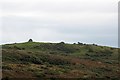
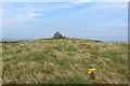
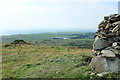
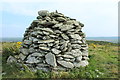
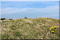
This small fort occupies the summit of the Fell of Barhullion and offers extensive views in all directions except the east. The fort was built in two phases - the first one consisted of an earthen rampart, the second one added a stone wall. The debris from the wall constructed during the second phase are clearly visible in the western part of the fort.
For a plan of the site see Fell of Barhullion on ScotlandsPlaces. For more information see Canmore ID 62757.
You may be viewing yesterday's version of this page. To see the most up to date information please register for a free account.
")
")
Do not use the above information on other web sites or publications without permission of the contributor.
Nearby Images from Geograph Britain and Ireland:
©2012(licence)
©2015(licence)
©2015(licence)
©2015(licence)
©2015(licence)
The above images may not be of the site on this page, they are loaded from Geograph.
Please Submit an Image of this site or go out and take one for us!
Click here to see more info for this site
Nearby sites
Key: Red: member's photo, Blue: 3rd party photo, Yellow: other image, Green: no photo - please go there and take one, Grey: site destroyed
Download sites to:
KML (Google Earth)
GPX (GPS waypoints)
CSV (Garmin/Navman)
CSV (Excel)
To unlock full downloads you need to sign up as a Contributory Member. Otherwise downloads are limited to 50 sites.
Turn off the page maps and other distractions
Nearby sites listing. In the following links * = Image available
191m SE 131° Blairbuy 5* Rock Art (NX37594175)
450m N 359° Blairbuy 3* Rock Art (NX37464233)
659m W 278° Blairbuy 4 Rock Art (NX368420)
676m SSW 209° Blairbuy 1* Rock Art (NX371413)
729m SSW 191° Blairbuy 2* Rock Art (NX37284117)
920m NW 305° Blairbuy 6* Rock Art (NX36714243)
1.3km WSW 255° Milton Hill* Standing Stones (NX36174159)
1.4km W 273° Wren's Egg* Standing Stones (NX36104199)
1.6km WNW 303° Black Loch of Myrton Settlement* Crannog (NX3610442835)
1.7km SSW 212° Knock Rock Art (4)* Rock Art (NX365405)
1.7km NW 316° Lady Well (Monreith Mains) Holy Well or Sacred Spring (NX36314315)
2.0km SSW 194° Knock 5* Carving (NX36903995)
2.0km SSW 207° Knock Rock Art (1)* Rock Art (NX36454012)
2.1km SSW 207° St Medana's Well* Holy Well or Sacred Spring (NX36454005)
2.1km SSW 203° Kirkmaiden Old Church* Ancient Cross (NX3655739968)
2.1km NW 309° White Loch of Myrton* Crannog (NX35854328)
2.5km SSW 194° Boden Walls Well Holy Well or Sacred Spring (NX36773947)
2.6km NNW 336° Drumtroddan Stone Row* Stone Row / Alignment (NX36454430)
2.8km WSW 254° Barsalloch* Promontory Fort / Cliff Castle (NX3472041210)
3.1km NNW 335° Drumtroddan Cup and Ring Markings* Rock Art (NX36264474)
3.5km NE 49° White Loch. Crannog (NX40174404)
5.2km SSE 151° Laggan Camp* Hillfort (NX3976437252)
5.5km SE 143° Glasserton Mains* Rock Art (NX40613737)
5.8km ESE 108° Rispain Camp* Ancient Village or Settlement (NX4293039930)
5.8km NNE 31° Dowalton Crannogs* Crannog (NX40614681)
View more nearby sites and additional images


 We would like to know more about this location. Please feel free to add a brief description and any relevant information in your own language.
 Wir möchten mehr über diese Stätte erfahren. Bitte zögern Sie nicht, eine kurze Beschreibung und relevante Informationen in Deutsch hinzuzufügen.
 Nous aimerions en savoir encore un peu sur les lieux. S'il vous plaît n'hesitez pas à ajouter une courte description et tous les renseignements pertinents dans votre propre langue.
 Quisieramos informarnos un poco más de las lugares. No dude en añadir una breve descripción y otros datos relevantes en su propio idioma.