<< Our Photo Pages >> Torhousekie Standing Stone - Standing Stone (Menhir) in Scotland in Dumfries and Galloway
Submitted by SumDoood on Tuesday, 22 March 2016 Page Views: 2272
Neolithic and Bronze AgeSite Name: Torhousekie Standing Stone Alternative Name: Torhouse Standing Stone; Cunningham; CunninghameCountry: Scotland County: Dumfries and Galloway Type: Standing Stone (Menhir)
Nearest Town: Wigtown Nearest Village: Spittal / Bladnoch
Map Ref: NX3843456097
Latitude: 54.873463N Longitude: 4.51952W
Condition:
| 5 | Perfect |
| 4 | Almost Perfect |
| 3 | Reasonable but with some damage |
| 2 | Ruined but still recognisable as an ancient site |
| 1 | Pretty much destroyed, possibly visible as crop marks |
| 0 | No data. |
| -1 | Completely destroyed |
| 5 | Superb |
| 4 | Good |
| 3 | Ordinary |
| 2 | Not Good |
| 1 | Awful |
| 0 | No data. |
| 5 | Can be driven to, probably with disabled access |
| 4 | Short walk on a footpath |
| 3 | Requiring a bit more of a walk |
| 2 | A long walk |
| 1 | In the middle of nowhere, a nightmare to find |
| 0 | No data. |
| 5 | co-ordinates taken by GPS or official recorded co-ordinates |
| 4 | co-ordinates scaled from a detailed map |
| 3 | co-ordinates scaled from a bad map |
| 2 | co-ordinates of the nearest village |
| 1 | co-ordinates of the nearest town |
| 0 | no data |
Internal Links:
External Links:
I have visited· I would like to visit
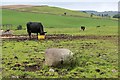
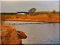
markj99 visited on 11th May 2022 - their rating: Cond: 3 Amb: 3 Access: 4 The Cunningham Stone is easily visited from Cunninghame Farm road, lying adjacent to a gateway. It is close to some cattle feeders so the area surrounding it may be muddy.
Anne T visited (still working on) on 17th Jun 2019 Torhouskie Standing Stone: At the time of our visit, the only route to this stone was either along the very busy minor road then down the farm track (didn't fancy getting run over as sight lines for cars weren't very good) or across the field. With The Huge Bull standing guard, and watching our every move, we had a quick chat with another visitor who was keen to see the stones, we decided we were not brave enough to risk it!
Seeing SumDoood's photographs of this stone on the site page, the size of the stone is very similar in size and shape to the one lying in the field just to the east of the stone circle.
On my list for another visit.
")
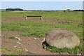
A standing stone very similar in size and shape to those used to build the Torhouse(kie) circle. The approach is down the farm road to "Cunninghame". The stone is clearly visible from that farm road in an area of the field likely to continue to be much muddied by cattle.
This stone is recorded as Canmore ID 62845 which adds that this is:"A single pointed boulder, oval in section, set up on end, about 3 1/2' in height and the same in breadth."
You may be viewing yesterday's version of this page. To see the most up to date information please register for a free account.
")
")
")
")
Do not use the above information on other web sites or publications without permission of the contributor.
Nearby Images from Geograph Britain and Ireland:
©2012(licence)
©2014(licence)
©2011(licence)
©2016(licence)
©2011(licence)
The above images may not be of the site on this page, they are loaded from Geograph.
Please Submit an Image of this site or go out and take one for us!
Click here to see more info for this site
Nearby sites
Key: Red: member's photo, Blue: 3rd party photo, Yellow: other image, Green: no photo - please go there and take one, Grey: site destroyed
Download sites to:
KML (Google Earth)
GPX (GPS waypoints)
CSV (Garmin/Navman)
CSV (Excel)
To unlock full downloads you need to sign up as a Contributory Member. Otherwise downloads are limited to 50 sites.
Turn off the page maps and other distractions
Nearby sites listing. In the following links * = Image available
405m NNW 334° Torhousekie Stones East* Standing Stones (NX3827156468)
414m NW 324° Torhouseskie South West Standing Stones* Standing Stones (NX38205644)
416m N 351° Torhousekie East* Stone Row / Alignment (NX38385651)
434m NNW 334° Torhousekie stone circle* Stone Circle (NX3825556493)
558m NNW 332° Torhousekie N* Cairn (NX38195660)
601m NNW 343° Torhouse North Cairn* Cairn (NX3828156679)
624m NNW 333° Torhouse North Side Cairn* Cairn (NX3817456665)
856m NW 319° Torhousekie Farm Cairn* Cairn (NX37895676)
1.9km WSW 258° White Cairn (Crouse)* Cairn (NX36585577)
1.9km WSW 257° Crow Stone (Wigtown)* Standing Stone (Menhir) (NX3658555732)
3.3km NE 54° Cairnhouse W* Cairn (NX41205798)
3.4km WNW 302° Spittal Croft cairn* Cairn (NX35645800)
3.4km SSW 195° Culmalzie (Whauphill) Holy Well or Sacred Spring (NX37405281)
3.5km ESE 106° Neilson's Hill* Rock Art (NX4176655018)
3.6km S 169° Barvernochan Standing Stone* Standing Stone (Menhir) (NX38975255)
3.8km WNW 300° Knocknocher stone pair* Standing Stones (NX35225808)
3.8km WNW 302° Whitecairn (Boreland)* Cairn (NX35285819)
3.9km ENE 56° Cairnhouse E* Cairn (NX41765813)
4.3km ESE 114° Bladnoch* Standing Stone (Menhir) (NX4229254238)
5.4km N 356° Cairn Hill (Barraer)* Cairn (NX38226149)
5.9km SE 139° St. Kennera's Cross* Ancient Cross (NX42195150)
6.3km NNE 25° High Baltersan* Cairn (NX41346168)
7.1km SE 134° North Balfern Cup and Rings* Rock Art (NX43375098)
7.4km SE 132° Ring Hill* Hillfort (NX43725095)
7.9km NW 322° Barhoise* Cairn (NX33776245)
View more nearby sites and additional images


 We would like to know more about this location. Please feel free to add a brief description and any relevant information in your own language.
 Wir möchten mehr über diese Stätte erfahren. Bitte zögern Sie nicht, eine kurze Beschreibung und relevante Informationen in Deutsch hinzuzufügen.
 Nous aimerions en savoir encore un peu sur les lieux. S'il vous plaît n'hesitez pas à ajouter une courte description et tous les renseignements pertinents dans votre propre langue.
 Quisieramos informarnos un poco más de las lugares. No dude en añadir una breve descripción y otros datos relevantes en su propio idioma.