<< Our Photo Pages >> White Loch of Myrton - Crannog in Scotland in Dumfries and Galloway
Submitted by markj99 on Wednesday, 19 July 2023 Page Views: 7077
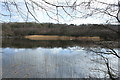
Iron Age and Later PrehistorySite Name: White Loch of Myrton Alternative Name: Monreith HouseCountry: Scotland County: Dumfries and Galloway Type: Crannog
Nearest Town: Whithorn Nearest Village: Monreith
Map Ref: NX35854328
Latitude: 54.757557N Longitude: 4.552476W
Condition:
| 5 | Perfect |
| 4 | Almost Perfect |
| 3 | Reasonable but with some damage |
| 2 | Ruined but still recognisable as an ancient site |
| 1 | Pretty much destroyed, possibly visible as crop marks |
| 0 | No data. |
| -1 | Completely destroyed |
| 5 | Superb |
| 4 | Good |
| 3 | Ordinary |
| 2 | Not Good |
| 1 | Awful |
| 0 | No data. |
| 5 | Can be driven to, probably with disabled access |
| 4 | Short walk on a footpath |
| 3 | Requiring a bit more of a walk |
| 2 | A long walk |
| 1 | In the middle of nowhere, a nightmare to find |
| 0 | No data. |
| 5 | co-ordinates taken by GPS or official recorded co-ordinates |
| 4 | co-ordinates scaled from a detailed map |
| 3 | co-ordinates scaled from a bad map |
| 2 | co-ordinates of the nearest village |
| 1 | co-ordinates of the nearest town |
| 0 | no data |
Internal Links:
External Links:
I have visited· I would like to visit
markj99 visited on 16th Jul 2023 - their rating: Cond: 2 Amb: 3 Access: 4 Take the A747 Port William turn off the A75 at Glenluce. Take the first exit to Wigtown off the small roundabout in the centre of Port William. Follow the B7085 for 0.8 miles to reach an unsigned sharp right turn towards Monreith. Follow the lane for c. 0.2 miles to the gates of Monreith Estate. It is possible to park at the estate gate. A muddy track is followed for c. 0.4 mile past the private road to Monreith House to a Y-junction. Take the right turn for c. 400 yards to reach a path heading N into the wood surrounding the loch. Follow the winding path for c. 200 yards to the crannog in the SE corner of White Loch of Myrton. If you want to see the crannog from the W, return to the Y-junction, take the left path for c. 400 yards. My route is viewable on White Loch of Myrton.
")
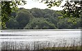
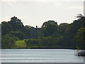
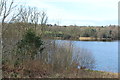
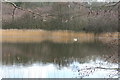
White Loch of Myrton is accessible to view the crannog from a public path round the loch in Monreith House Estate. Parking is possible at the estate entrance. The best views of the crannog are from the west bank. It is possible to approach the crannog from the east via a woodland path veering off the loch circuit. The views of the crannog from the east bank are restricted by trees bordering the loch.
Ref: Canmore ID 62814.
You may be viewing yesterday's version of this page. To see the most up to date information please register for a free account.
")
")
Do not use the above information on other web sites or publications without permission of the contributor.
Nearby Images from Geograph Britain and Ireland:
©2012(licence)
©2010(licence)
©2016(licence)
©2016(licence)
©2016(licence)
The above images may not be of the site on this page, they are loaded from Geograph.
Please Submit an Image of this site or go out and take one for us!
Click here to see more info for this site
Nearby sites
Key: Red: member's photo, Blue: 3rd party photo, Yellow: other image, Green: no photo - please go there and take one, Grey: site destroyed
Download sites to:
KML (Google Earth)
GPX (GPS waypoints)
CSV (Garmin/Navman)
CSV (Excel)
To unlock full downloads you need to sign up as a Contributory Member. Otherwise downloads are limited to 50 sites.
Turn off the page maps and other distractions
Nearby sites listing. In the following links * = Image available
477m ESE 104° Lady Well (Monreith Mains) Holy Well or Sacred Spring (NX36314315)
512m SSE 148° Black Loch of Myrton Settlement* Crannog (NX3610442835)
1.2km NNE 28° Drumtroddan Stone Row* Stone Row / Alignment (NX36454430)
1.2km SE 133° Blairbuy 6* Rock Art (NX36714243)
1.3km SSE 167° Wren's Egg* Standing Stones (NX36104199)
1.5km NNE 14° Drumtroddan Cup and Ring Markings* Rock Art (NX36264474)
1.6km SE 141° Blairbuy 4 Rock Art (NX368420)
1.7km SSE 167° Milton Hill* Standing Stones (NX36174159)
1.9km ESE 119° Blairbuy 3* Rock Art (NX37464233)
2.1km SE 129° Fell of Barhullion* Hillfort (NX37454188)
2.3km SE 129° Blairbuy 5* Rock Art (NX37594175)
2.3km SE 146° Blairbuy 1* Rock Art (NX371413)
2.4km SSW 206° Barsalloch* Promontory Fort / Cliff Castle (NX3472041210)
2.5km SE 144° Blairbuy 2* Rock Art (NX37284117)
2.9km SSE 165° Knock Rock Art (4)* Rock Art (NX365405)
3.2km SSE 167° Knock Rock Art (1)* Rock Art (NX36454012)
3.3km SSE 167° St Medana's Well* Holy Well or Sacred Spring (NX36454005)
3.4km SSE 166° Kirkmaiden Old Church* Ancient Cross (NX3655739968)
3.5km SSE 160° Knock 5* Carving (NX36903995)
3.9km SSE 164° Boden Walls Well Holy Well or Sacred Spring (NX36773947)
4.4km ENE 78° White Loch. Crannog (NX40174404)
5.4km NNE 24° Longcastle School House* Standing Stone (Menhir) (NX3824948105)
5.7km NE 40° Miller's Cairn Crannog (NX397475)
5.9km NW 322° Elrig Cairn* Cairn (NX32404802)
5.9km NE 51° Dowalton Crannogs* Crannog (NX40614681)
View more nearby sites and additional images


 We would like to know more about this location. Please feel free to add a brief description and any relevant information in your own language.
 Wir möchten mehr über diese Stätte erfahren. Bitte zögern Sie nicht, eine kurze Beschreibung und relevante Informationen in Deutsch hinzuzufügen.
 Nous aimerions en savoir encore un peu sur les lieux. S'il vous plaît n'hesitez pas à ajouter une courte description et tous les renseignements pertinents dans votre propre langue.
 Quisieramos informarnos un poco más de las lugares. No dude en añadir una breve descripción y otros datos relevantes en su propio idioma.