

<< Our Photo Pages >> Craddock Moor embanked avenue - Misc. Earthwork in England in Cornwall
Submitted by thecaptain on Wednesday, 07 October 2009 Page Views: 6369
Multi-periodSite Name: Craddock Moor embanked avenueCountry: England County: Cornwall Type: Misc. Earthwork
Nearest Town: Liskeard Nearest Village: Minions
Map Ref: SX24377208
Latitude: 50.522082N Longitude: 4.479004W
Condition:
| 5 | Perfect |
| 4 | Almost Perfect |
| 3 | Reasonable but with some damage |
| 2 | Ruined but still recognisable as an ancient site |
| 1 | Pretty much destroyed, possibly visible as crop marks |
| 0 | No data. |
| -1 | Completely destroyed |
| 5 | Superb |
| 4 | Good |
| 3 | Ordinary |
| 2 | Not Good |
| 1 | Awful |
| 0 | No data. |
| 5 | Can be driven to, probably with disabled access |
| 4 | Short walk on a footpath |
| 3 | Requiring a bit more of a walk |
| 2 | A long walk |
| 1 | In the middle of nowhere, a nightmare to find |
| 0 | No data. |
| 5 | co-ordinates taken by GPS or official recorded co-ordinates |
| 4 | co-ordinates scaled from a detailed map |
| 3 | co-ordinates scaled from a bad map |
| 2 | co-ordinates of the nearest village |
| 1 | co-ordinates of the nearest town |
| 0 | no data |
Internal Links:
External Links:
I have visited· I would like to visit
TheCaptain has visited here
")
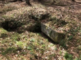
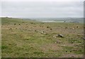
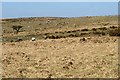
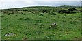
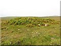
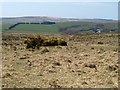
It is positioned down in the little valley leading towards the northern end of Siblyback Lake from the top of Craddock Moor. In this area are to be found many circular cairns and the remains of this prehistoric embanked avenue. It is difficult to see and figure out amongst the ferns and other overgrowth, and hence quite difficult to find, but you will know it when you find it, especially the southeastern end which is in much better condition than the northwestern end.
The avenue is about 60 metres long, with its two parallel banks separated by a flat area about 4 metres wide, making up a total width of between 8 and 10 metres across. The banks are still about half a metre to a metre in height, and in places seem to have got some stone slabs along the inner edges, perhaps once making a sort of kerb. At more than one position along its length, the banks have been broken down, either for an old trackway of for some early mining practise.
The avenue lines up exactly between the upper, northern end of the nearby Craddock Moor stone row, and the centre of the Craddock Moor stone circle, which cannot be seen on the top of the moorland (but perhaps was visible if the stones were all standing). Apparently, if this line is continued onwards towards the southeast, it also leads directly to the southern circle of the Hurlers stone circles. Is this just a coincidence or a deliberate positioning of all these monuments, somehow linked together.
In some ways, this reminded me in a very small way of a smaller version of King Arthurs Hall. It was almost impossible to photograph.
English Heritage Scheduled Monument 15065
You may be viewing yesterday's version of this page. To see the most up to date information please register for a free account.
")
")
")
Do not use the above information on other web sites or publications without permission of the contributor.
Nearby Images from Geograph Britain and Ireland:
©2006(licence)
©2015(licence)
©2020(licence)
©2012(licence)
©2015(licence)
The above images may not be of the site on this page, they are loaded from Geograph.
Please Submit an Image of this site or go out and take one for us!
Click here to see more info for this site
Nearby sites
Key: Red: member's photo, Blue: 3rd party photo, Yellow: other image, Green: no photo - please go there and take one, Grey: site destroyed
Download sites to:
KML (Google Earth)
GPX (GPS waypoints)
CSV (Garmin/Navman)
CSV (Excel)
To unlock full downloads you need to sign up as a Contributory Member. Otherwise downloads are limited to 50 sites.
Turn off the page maps and other distractions
Nearby sites listing. In the following links * = Image available
333m WNW 298° Craddock Moor stone row* Stone Row / Alignment (SX2407972244)
415m ENE 61° Craddock Moor Stone Setting* Standing Stones (SX24747227)
558m ESE 115° Craddock Moor circle* Stone Circle (SX24877183)
628m NW 314° Craddock Moor Hut Circle* Ancient Village or Settlement (SX23937253)
651m S 180° Craddock Moor Cairn Cemetery* Barrow Cemetery (SX2435071429)
659m E 99° Craddock Moor platform cairn* Cairn (SX25027196)
896m S 189° Tregarrick Tor hillfort* Hillfort (SX242712)
955m SSW 191° Tregarrick Tor cairn* Chambered Cairn (SX24157115)
1.0km SSW 205° Tregarrick menhir* Standing Stone (Menhir) (SX23917116)
1.0km NNW 346° Craddock Moor Prehistoric Settlement* Ancient Village or Settlement (SX24157310)
1.1km SE 135° Minions Round Cairns* Round Cairn (SX25157126)
1.3km SE 142° Trewalla Farm Settlement* Ancient Village or Settlement (SX25117106)
1.3km SE 142° Minions Bronze Age round cairn. Cairn (SX25157103)
1.4km SE 139° Minions Kerbed Cairn Cairn (SX25247103)
1.4km E 97° The Hurlers Avenue* Multiple Stone Rows / Avenue (SX2576371864)
1.4km ENE 76° The Cheesewring* Natural Stone / Erratic / Other Natural Feature (SX25787239)
1.5km ENE 73° Stowe's Pound* Ancient Village or Settlement (SX25787247)
1.5km ESE 117° The Hurlers Pipers* Standing Stones (SX25717135)
1.6km ESE 106° The Hurlers North* Stone Circle (SX25877159)
1.6km ESE 111° The Hurlers (N)* Stone Circle (SX25847145)
1.6km ESE 112° The Hurlers causeway* Ancient Trackway (SX25837142)
1.6km ESE 114° The Hurlers (C)* Stone Circle (SX25827139)
1.6km ESE 113° The Hurlers* Stone Circle (SX25837140)
1.6km ESE 116° The Hurlers (S)* Stone Circle (SX25817133)
1.6km E 93° Rillaton N Cairn* Cairn (SX26007195)
View more nearby sites and additional images


 We would like to know more about this location. Please feel free to add a brief description and any relevant information in your own language.
 Wir möchten mehr über diese Stätte erfahren. Bitte zögern Sie nicht, eine kurze Beschreibung und relevante Informationen in Deutsch hinzuzufügen.
 Nous aimerions en savoir encore un peu sur les lieux. S'il vous plaît n'hesitez pas à ajouter une courte description et tous les renseignements pertinents dans votre propre langue.
 Quisieramos informarnos un poco más de las lugares. No dude en añadir una breve descripción y otros datos relevantes en su propio idioma.