


<< Our Photo Pages >> Llanfyrnach A - Standing Stone (Menhir) in Wales in Pembrokeshire
Submitted by vicky on Saturday, 24 January 2004 Page Views: 5280
Neolithic and Bronze AgeSite Name: Llanfyrnach A Alternative Name: Brynmeini 2, Hermon 2Country: Wales
NOTE: This site is 0.2 km away from the location you searched for.
County: Pembrokeshire Type: Standing Stone (Menhir)
Nearest Village: Hermon
Map Ref: SN20753141 Landranger Map Number: 145
Latitude: 51.952217N Longitude: 4.609822W
Condition:
| 5 | Perfect |
| 4 | Almost Perfect |
| 3 | Reasonable but with some damage |
| 2 | Ruined but still recognisable as an ancient site |
| 1 | Pretty much destroyed, possibly visible as crop marks |
| 0 | No data. |
| -1 | Completely destroyed |
| 5 | Superb |
| 4 | Good |
| 3 | Ordinary |
| 2 | Not Good |
| 1 | Awful |
| 0 | No data. |
| 5 | Can be driven to, probably with disabled access |
| 4 | Short walk on a footpath |
| 3 | Requiring a bit more of a walk |
| 2 | A long walk |
| 1 | In the middle of nowhere, a nightmare to find |
| 0 | No data. |
| 5 | co-ordinates taken by GPS or official recorded co-ordinates |
| 4 | co-ordinates scaled from a detailed map |
| 3 | co-ordinates scaled from a bad map |
| 2 | co-ordinates of the nearest village |
| 1 | co-ordinates of the nearest town |
| 0 | no data |
Internal Links:
External Links:
")
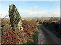
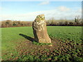
Two stones stand in a field between Hermon and Llanfyrnach. According to the OS Map they should be on a footpath, but all traces of this have vanished on the ground. One of the stones can be seen from the lane.
Coflein site no. 304107.
You may be viewing yesterday's version of this page. To see the most up to date information please register for a free account.
")
Do not use the above information on other web sites or publications without permission of the contributor.
Nearby Images from Geograph Britain and Ireland:
©2024(licence)
©2024(licence)

©2024(licence)
©2024(licence)
©2015(licence)
The above images may not be of the site on this page, they are loaded from Geograph.
Please Submit an Image of this site or go out and take one for us!
Click here to see more info for this site
Nearby sites
Key: Red: member's photo, Blue: 3rd party photo, Yellow: other image, Green: no photo - please go there and take one, Grey: site destroyed
Download sites to:
KML (Google Earth)
GPX (GPS waypoints)
CSV (Garmin/Navman)
CSV (Excel)
To unlock full downloads you need to sign up as a Contributory Member. Otherwise downloads are limited to 50 sites.
Turn off the page maps and other distractions
Nearby sites listing. In the following links * = Image available
204m SSE 167° Llanfyrnach B* Standing Stone (Menhir) (SN20793121)
544m SE 129° Llanfyrnach C* Standing Stone (Menhir) (SN21163105)
764m E 100° Rhyd-y-Gath* Early Christian Sculptured Stone (SN21503125)
2.9km NNW 339° Frenni Fawr foot Round Barrow(s) (SN198341)
3.1km WSW 247° Ffynon Delyn Henge (SN178303)
3.3km SSW 208° Efessangus stone* Early Christian Sculptured Stone (SN191286)
3.4km E 98° Castell y Blaidd* Cairn (SN241308)
3.5km NW 311° Crymych Wayside Barrow* Round Barrow(s) (SN18203375)
3.6km WNW 286° Crug yr Hwch Round Cairn (SN173325)
3.6km WSW 257° Pentre Galar* Cairn (SN172307)
3.6km SSE 158° Ffynnonwen Iron Age Settlement Ancient Village or Settlement (SN2228)
3.7km NNW 346° Frenni Fawr top* Barrow Cemetery (SN2035)
3.7km SE 131° Crugel Win* Round Barrow(s) (SN23492888)
3.9km NNE 26° Frenni Fach* Round Barrow(s) (SN226349)
4.4km WNW 294° Croesmihangel Ancient Village or Settlement (SN168333)
4.4km WNW 287° Mountain Burial Chamber* Burial Chamber or Dolmen (SN16573285)
4.6km WSW 258° Dolaumaen Standing Stone* Standing Stone (Menhir) (SN1622030632)
4.6km WNW 291° Croesmihangel Barrow* Round Barrow(s) (SN165332)
4.9km S 170° Crug Hywel Cairn Cairn (SN214266)
4.9km NW 326° Maen Gwyn Menhir* Standing Stone (Menhir) (SN18123560)
5.0km W 266° Waun Llwyd.* Standing Stones (SN1578131265)
5.0km WSW 252° Foel Dyrch, Pentre Galar Cairn (SN159300)
5.1km WNW 286° Carn Gaseg Ring Cairn (SN159330)
5.3km S 170° Tumulus at Pantglas* Cairn (SN215262)
5.4km WNW 292° Foel Drygarn Fort* Hillfort (SN158336)
View more nearby sites and additional images


 We would like to know more about this location. Please feel free to add a brief description and any relevant information in your own language.
 Wir möchten mehr über diese Stätte erfahren. Bitte zögern Sie nicht, eine kurze Beschreibung und relevante Informationen in Deutsch hinzuzufügen.
 Nous aimerions en savoir encore un peu sur les lieux. S'il vous plaît n'hesitez pas à ajouter une courte description et tous les renseignements pertinents dans votre propre langue.
 Quisieramos informarnos un poco más de las lugares. No dude en añadir una breve descripción y otros datos relevantes en su propio idioma.