<< Text Pages >> Gouklan Stone - Standing Stone (Menhir) in Scotland in North Ayrshire
Submitted by DavidHoyle on Monday, 12 June 2023 Page Views: 373
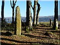
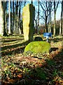
Neolithic and Bronze AgeSite Name: Gouklan Stone Alternative Name: Druids' StoneCountry: Scotland County: North Ayrshire Type: Standing Stone (Menhir)
Nearest Town: Millport
Map Ref: NS17615641
Latitude: 55.766547N Longitude: 4.908866W
Condition:
| 5 | Perfect |
| 4 | Almost Perfect |
| 3 | Reasonable but with some damage |
| 2 | Ruined but still recognisable as an ancient site |
| 1 | Pretty much destroyed, possibly visible as crop marks |
| 0 | No data. |
| -1 | Completely destroyed |
| 5 | Superb |
| 4 | Good |
| 3 | Ordinary |
| 2 | Not Good |
| 1 | Awful |
| 0 | No data. |
| 5 | Can be driven to, probably with disabled access |
| 4 | Short walk on a footpath |
| 3 | Requiring a bit more of a walk |
| 2 | A long walk |
| 1 | In the middle of nowhere, a nightmare to find |
| 0 | No data. |
| 5 | co-ordinates taken by GPS or official recorded co-ordinates |
| 4 | co-ordinates scaled from a detailed map |
| 3 | co-ordinates scaled from a bad map |
| 2 | co-ordinates of the nearest village |
| 1 | co-ordinates of the nearest town |
| 0 | no data |
Internal Links:
External Links:
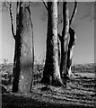
Standing Stone marked on OS Map on Great Cumbrae Island near Craigengour. The following is taken from Canmore: The stone stands about 6ft high and 14 inches broad. It is supposed to be a memorial to some of the Norwegians who fell at the Battle of Largs in 1263.
Name Book 1855
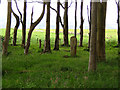
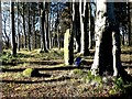
This stone is known as the Gouklan Stone. There are eight large boulders nearby, and two other pillars are reported to have been closely associated with it. A circle of pits dug around the stone revealed nothing.
W Lytteil 1886; J K Hewison 1893
The stone is as described in the Ordnance Survey Name Book (ONB). It was pulled down some years ago by vandals but has since been re-erected and set in concrete. The north face of the stone has been smoothed and a list of initials inscribed. Nothing was seen of the boulders noted by Lytteil and the name Gouklan is not known locally where the stone is referred to as the 'Druids stone'.
Canmore
geograph
You may be viewing yesterday's version of this page. To see the most up to date information please register for a free account.
Do not use the above information on other web sites or publications without permission of the contributor.
Nearby Images from Geograph Britain and Ireland:
©2010(licence)
©2016(licence)
©2016(licence)
©2017(licence)
©2017(licence)
The above images may not be of the site on this page, they are loaded from Geograph.
Please Submit an Image of this site or go out and take one for us!
Click here to see more info for this site
Nearby sites
Key: Red: member's photo, Blue: 3rd party photo, Yellow: other image, Green: no photo - please go there and take one, Grey: site destroyed
Download sites to:
KML (Google Earth)
GPX (GPS waypoints)
CSV (Garmin/Navman)
CSV (Excel)
To unlock full downloads you need to sign up as a Contributory Member. Otherwise downloads are limited to 50 sites.
Turn off the page maps and other distractions
Nearby sites listing. In the following links * = Image available
1.0km WNW 302° Glaid Stone* Natural Stone / Erratic / Other Natural Feature (NS16765700)
2.8km N 10° Tomont End Cairns, Isle of Great Cumbrae* Cairn (NS182591)
3.6km NE 50° Broomfields Menhir Standing Stone (Menhir) (NS20475864)
4.0km NE 54° Haylie* Chambered Cairn (NS2094558592)
4.5km ESE 121° Southannan 1 Rock Art (NS21395390)
4.6km ENE 56° Castle Hill Fort (Largs)* Hillfort (NS2156558800)
4.6km SE 127° Southannan 2 Rock Art (NS21205350)
4.6km ESE 120° Southannan Menhir Standing Stone (Menhir) (NS21535392)
5.5km ENE 74° Fechan Menhir Standing Stone (Menhir) (NS22975775)
5.6km S 174° Hawking Craig Cave or Rock Shelter (NS17945079)
5.7km SE 139° Biglees Cairn Cairn (NS21125196)
5.9km ESE 118° Kaim Hill Cairn Cairn (NS22715342)
6.2km SE 140° Glentane Standing Stones Standing Stones (NS21445152)
7.0km NNE 20° Knock Hill Fort Hillfort (NS20286286)
7.3km S 176° Auld Hill Fort (Portencross) Hillfort (NS17834910)
7.4km SE 132° Caldron Cairn Cairn (NS22905115)
7.7km SE 132° Little Caldron Cairn Cairn (NS23155100)
8.4km WNW 300° Mountstuart* Cist (NS1048360922)
8.4km W 263° Blackpark* Stone Circle (NS0916455666)
8.6km WSW 247° St Blane's Chapel (Isle of Bute)* Ancient Cross (NS0949853405)
8.7km WSW 248° St Blane's Well* Ancient Cross (NS0944253442)
8.7km WSW 247° St Blane's Broch* Broch or Nuraghe (NS094534)
9.2km W 261° Stravanan Bay* Stone Row / Alignment (NS0846555361)
9.5km WSW 248° Dunagoil* Burial Chamber or Dolmen (NS08595322)
9.6km N 9° Skelmorlie Serpent Mound Artificial Mound (NS195658)
View more nearby sites and additional images


 We would like to know more about this location. Please feel free to add a brief description and any relevant information in your own language.
 Wir möchten mehr über diese Stätte erfahren. Bitte zögern Sie nicht, eine kurze Beschreibung und relevante Informationen in Deutsch hinzuzufügen.
 Nous aimerions en savoir encore un peu sur les lieux. S'il vous plaît n'hesitez pas à ajouter une courte description et tous les renseignements pertinents dans votre propre langue.
 Quisieramos informarnos un poco más de las lugares. No dude en añadir una breve descripción y otros datos relevantes en su propio idioma.