


<< Image Pages >> Tomont End Cairns, Isle of Great Cumbrae - Cairn in Scotland in North Ayrshire
Submitted by durhamnature on Saturday, 15 September 2012 Page Views: 4479
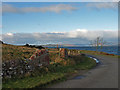
Neolithic and Bronze AgeSite Name: Tomont End Cairns, Isle of Great CumbraeCountry: Scotland County: North Ayrshire Type: Cairn
Map Ref: NS182591
Latitude: 55.790908N Longitude: 4.90127W
Condition:
| 5 | Perfect |
| 4 | Almost Perfect |
| 3 | Reasonable but with some damage |
| 2 | Ruined but still recognisable as an ancient site |
| 1 | Pretty much destroyed, possibly visible as crop marks |
| 0 | No data. |
| -1 | Completely destroyed |
| 5 | Superb |
| 4 | Good |
| 3 | Ordinary |
| 2 | Not Good |
| 1 | Awful |
| 0 | No data. |
| 5 | Can be driven to, probably with disabled access |
| 4 | Short walk on a footpath |
| 3 | Requiring a bit more of a walk |
| 2 | A long walk |
| 1 | In the middle of nowhere, a nightmare to find |
| 0 | No data. |
| 5 | co-ordinates taken by GPS or official recorded co-ordinates |
| 4 | co-ordinates scaled from a detailed map |
| 3 | co-ordinates scaled from a bad map |
| 2 | co-ordinates of the nearest village |
| 1 | co-ordinates of the nearest town |
| 0 | no data |
Internal Links:
External Links:
I have visited· I would like to visit
SumDoood would like to visit
")
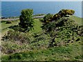
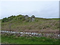
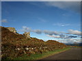
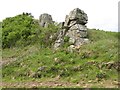
Group of cairns at the northern end of the Isle of Great Cumbrae, looking over the sea to mainland Scotland. Excavations recorded in Scottish Historical Review found a number of urns and flints.
You may be viewing yesterday's version of this page. To see the most up to date information please register for a free account.
")
")
")
Do not use the above information on other web sites or publications without permission of the contributor.
Nearby Images from Geograph Britain and Ireland:
©2017(licence)
©2011(licence)
©2008(licence)
©2018(licence)
©2008(licence)
The above images may not be of the site on this page, they are loaded from Geograph.
Please Submit an Image of this site or go out and take one for us!
Click here to see more info for this site
Nearby sites
Key: Red: member's photo, Blue: 3rd party photo, Yellow: other image, Green: no photo - please go there and take one, Grey: site destroyed
Download sites to:
KML (Google Earth)
GPX (GPS waypoints)
CSV (Garmin/Navman)
CSV (Excel)
To unlock full downloads you need to sign up as a Contributory Member. Otherwise downloads are limited to 50 sites.
Turn off the page maps and other distractions
Nearby sites listing. In the following links * = Image available
2.3km E 99° Broomfields Menhir Standing Stone (Menhir) (NS20475864)
2.5km SSW 212° Glaid Stone* Natural Stone / Erratic / Other Natural Feature (NS16765700)
2.8km S 190° Gouklan Stone Standing Stone (Menhir) (NS17615641)
2.8km E 98° Haylie* Chambered Cairn (NS2094558592)
3.4km E 93° Castle Hill Fort (Largs)* Hillfort (NS2156558800)
4.3km NNE 27° Knock Hill Fort Hillfort (NS20286286)
4.9km ESE 103° Fechan Menhir Standing Stone (Menhir) (NS22975775)
6.1km SE 146° Southannan 1 Rock Art (NS21395390)
6.1km SE 145° Southannan Menhir Standing Stone (Menhir) (NS21535392)
6.3km SSE 149° Southannan 2 Rock Art (NS21205350)
6.8km N 9° Skelmorlie Serpent Mound Artificial Mound (NS195658)
7.2km SE 139° Kaim Hill Cairn Cairn (NS22715342)
7.7km SSE 155° Biglees Cairn Cairn (NS21125196)
7.9km W 281° Mountstuart* Cist (NS1048360922)
8.2km SSE 155° Glentane Standing Stones Standing Stones (NS21445152)
8.3km S 179° Hawking Craig Cave or Rock Shelter (NS17945079)
9.2km NNE 28° Back o' the World Cup Marks Rock Art (NS2286067030)
9.2km SSE 147° Caldron Cairn Cairn (NS22905115)
9.5km SE 146° Little Caldron Cairn Cairn (NS23155100)
9.6km WSW 247° Blackpark* Stone Circle (NS0916455666)
9.8km NNE 17° Craigengowr Cist Cist (NS2142168420)
10.0km S 180° Auld Hill Fort (Portencross) Hillfort (NS17834910)
10.4km NNE 18° Blood Moss Cist B Cist (NS2178068830)
10.4km NNE 16° Blood Moss Cist C Cist (NS2140068970)
10.4km SW 234° St Blane's Chapel (Isle of Bute)* Ancient Cross (NS0949853405)
View more nearby sites and additional images


 We would like to know more about this location. Please feel free to add a brief description and any relevant information in your own language.
 Wir möchten mehr über diese Stätte erfahren. Bitte zögern Sie nicht, eine kurze Beschreibung und relevante Informationen in Deutsch hinzuzufügen.
 Nous aimerions en savoir encore un peu sur les lieux. S'il vous plaît n'hesitez pas à ajouter une courte description et tous les renseignements pertinents dans votre propre langue.
 Quisieramos informarnos un poco más de las lugares. No dude en añadir una breve descripción y otros datos relevantes en su propio idioma.