<< Our Photo Pages >> Bishop's Rock - Rock Art in Scotland in Argyll
Submitted by hamish on Tuesday, 21 August 2007 Page Views: 8438
Rock ArtSite Name: Bishop's RockCountry: Scotland County: Argyll Type: Rock Art
Nearest Town: Fort William Nearest Village: North Ballachulish
Map Ref: NN058599
Latitude: 56.690349N Longitude: 5.172695W
Condition:
| 5 | Perfect |
| 4 | Almost Perfect |
| 3 | Reasonable but with some damage |
| 2 | Ruined but still recognisable as an ancient site |
| 1 | Pretty much destroyed, possibly visible as crop marks |
| 0 | No data. |
| -1 | Completely destroyed |
| 5 | Superb |
| 4 | Good |
| 3 | Ordinary |
| 2 | Not Good |
| 1 | Awful |
| 0 | No data. |
| 5 | Can be driven to, probably with disabled access |
| 4 | Short walk on a footpath |
| 3 | Requiring a bit more of a walk |
| 2 | A long walk |
| 1 | In the middle of nowhere, a nightmare to find |
| 0 | No data. |
| 5 | co-ordinates taken by GPS or official recorded co-ordinates |
| 4 | co-ordinates scaled from a detailed map |
| 3 | co-ordinates scaled from a bad map |
| 2 | co-ordinates of the nearest village |
| 1 | co-ordinates of the nearest town |
| 0 | no data |
Internal Links:
External Links:
I have visited· I would like to visit
hamish has visited here
")
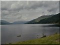
There cupmarks are on the edge of the small peninsula called Bishop's Island sticking out into Loch Leven.
It is near North Ballachulish and in easy walking distance.It's a bit of a scramble to reach the cupmarks but well worth the effort. On a summers day when clear there are magnificent views up the loch.
You may be viewing yesterday's version of this page. To see the most up to date information please register for a free account.
")
")
")
")
Do not use the above information on other web sites or publications without permission of the contributor.
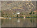
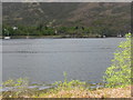
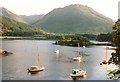
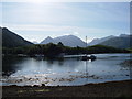
Nearby Images from Geograph Britain and Ireland:
©2010(licence)
©2013(licence)
©2005(licence)
©2006(licence)
©2009(licence)
The above images may not be of the site on this page, they are loaded from Geograph.
Please Submit an Image of this site or go out and take one for us!
Click here to see more info for this site
Nearby sites
Key: Red: member's photo, Blue: 3rd party photo, Yellow: other image, Green: no photo - please go there and take one, Grey: site destroyed
Download sites to:
KML (Google Earth)
GPX (GPS waypoints)
CSV (Garmin/Navman)
CSV (Excel)
To unlock full downloads you need to sign up as a Contributory Member. Otherwise downloads are limited to 50 sites.
Turn off the page maps and other distractions
Nearby sites listing. In the following links * = Image available
100m W 267° North Ballachulish* Rock Art (NN057599)
679m WNW 282° Rubha Mor* Cairn (NN05146007)
996m WSW 244° Ballachulish House* Chambered Cairn (NN04885951)
3.5km WNW 291° Clach-a-charra* Standing Stone (Menhir) (NN02566134)
8.9km SW 230° Achara Standing Stone* Standing Stone (Menhir) (NM98665455)
12.3km NNE 31° Dun Deardail* Vitrified Fort (NN127701)
13.9km NNE 27° Dun Dige* Round Barrow(s) (NN126720)
14.6km NNE 15° West Highland Museum* Museum (NN102738)
15.0km SE 142° Invercharnan (Glen Etive) Cairn (NN14394761)
15.0km NNE 23° Samuel's Stone* Natural Stone / Erratic / Other Natural Feature (NN122735)
16.8km SSW 205° St Cairrell's Well* Holy Well or Sacred Spring (NM980450)
18.2km SW 224° Cairnbane (Portnacroish) Chambered Cairn (NM926473)
20.1km SSW 205° Barcaldine* Standing Stones (NM96374213)
21.6km S 179° Muirheadstone* Natural Stone / Erratic / Other Natural Feature (NN050383)
22.2km SSW 208° Achacha standing stone* Standing Stone (Menhir) (NM94444075)
22.3km SSW 208° Achacha Cairn* Cairn (NM94364076)
23.5km SW 219° Eriska Crannog* Crannog (NM90114239)
24.2km W 271° Clach a' Phoanais (Strontian)* Standing Stone (Menhir) (NM8158061357)
24.5km SW 219° Balure Cairns* Cairn (NM89604145)
24.5km SW 214° Castle Farm cairns* Cairn (NM91014029)
24.5km SW 214° Castle Farm standing stone* Standing Stone (Menhir) (NM911402)
24.6km SW 217° Achnamoine 2* Cairn (NM89974104)
24.6km SW 217° Achnamoine Cairn* Cairn (NM90184082)
24.9km SSW 213° Culcharron cairn* Cairn (NM913396)
25.1km SW 228° Cnoc Aingil Cairn (NM86384397)
View more nearby sites and additional images


 We would like to know more about this location. Please feel free to add a brief description and any relevant information in your own language.
 Wir möchten mehr über diese Stätte erfahren. Bitte zögern Sie nicht, eine kurze Beschreibung und relevante Informationen in Deutsch hinzuzufügen.
 Nous aimerions en savoir encore un peu sur les lieux. S'il vous plaît n'hesitez pas à ajouter une courte description et tous les renseignements pertinents dans votre propre langue.
 Quisieramos informarnos un poco más de las lugares. No dude en añadir una breve descripción y otros datos relevantes en su propio idioma.