 with our Megalithic Portal iPhone app")


<< Our Photo Pages >> Dinas Fawr - Promontory Fort / Cliff Castle in Wales in Gwynedd
Submitted by Antonine on Tuesday, 30 April 2024 Page Views: 920
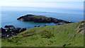
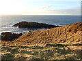
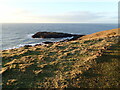
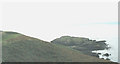
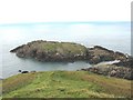
Iron Age and Later PrehistorySite Name: Dinas FawrCountry: Wales County: Gwynedd Type: Promontory Fort / Cliff Castle
Nearest Town: Pwllheli Nearest Village: Carreg
Map Ref: SH15542907
Latitude: 52.827501N Longitude: 4.73935W
Condition:
| 5 | Perfect |
| 4 | Almost Perfect |
| 3 | Reasonable but with some damage |
| 2 | Ruined but still recognisable as an ancient site |
| 1 | Pretty much destroyed, possibly visible as crop marks |
| 0 | No data. |
| -1 | Completely destroyed |
| 5 | Superb |
| 4 | Good |
| 3 | Ordinary |
| 2 | Not Good |
| 1 | Awful |
| 0 | No data. |
| 5 | Can be driven to, probably with disabled access |
| 4 | Short walk on a footpath |
| 3 | Requiring a bit more of a walk |
| 2 | A long walk |
| 1 | In the middle of nowhere, a nightmare to find |
| 0 | No data. |
| 5 | co-ordinates taken by GPS or official recorded co-ordinates |
| 4 | co-ordinates scaled from a detailed map |
| 3 | co-ordinates scaled from a bad map |
| 2 | co-ordinates of the nearest village |
| 1 | co-ordinates of the nearest town |
| 0 | no data |
Be the first person to rate this site - see the 'Contribute!' box in the right hand menu.
Internal Links:
External Links:
I have visited· I would like to visit
cactus_chris visited on 5th Aug 2025 - their rating: Cond: 5 Amb: 5 Access: 2
")
You may be viewing yesterday's version of this page. To see the most up to date information please register for a free account.
Do not use the above information on other web sites or publications without permission of the contributor.
Nearby Images from Geograph Britain and Ireland:
©2015(licence)
©2022(licence)
©2022(licence)
©2007(licence)
©2007(licence)
The above images may not be of the site on this page, they are loaded from Geograph.
Please Submit an Image of this site or go out and take one for us!
Click here to see more info for this site
Nearby sites
Key: Red: member's photo, Blue: 3rd party photo, Yellow: other image, Green: no photo - please go there and take one, Grey: site destroyed
Download sites to:
KML (Google Earth)
GPX (GPS waypoints)
CSV (Garmin/Navman)
CSV (Excel)
To unlock full downloads you need to sign up as a Contributory Member. Otherwise downloads are limited to 50 sites.
Turn off the page maps and other distractions
Nearby sites listing. In the following links * = Image available
384m NE 36° Dinas Bach (Carreg)* Promontory Fort / Cliff Castle (SH15782937)
1.3km NE 51° Porthor* Natural Stone / Erratic / Other Natural Feature (SH16542983)
2.0km S 179° Tynanelog Standing Stone* Standing Stone (Menhir) (SH155271)
2.6km SSE 155° Ffynnon Saint (Minafon)* Holy Well or Sacred Spring (SH16532671)
3.2km SE 144° The Anelog Stones* Early Christian Sculptured Stone (SH173264)
3.2km E 100° Castell Odo* Hillfort (SH187284)
3.8km SSW 203° Mynydd Mawr Hut Group Ancient Village or Settlement (SH13942566)
3.9km E 90° Ffynnon Ffol Holy Well or Sacred Spring (SH19402891)
4.2km SSW 200° St Mary's Well (Gwynedd)* Holy Well or Sacred Spring (SH13922518)
4.2km SSW 201° Maen Melyn (Lleyn)* Standing Stone (Menhir) (SH1384625202)
4.9km SE 136° Carreg Gybi Standing Stones (SH18852540)
5.8km ENE 71° Maenhir Penygroeslon Standing Stone (Menhir) (SH21093079)
5.9km ESE 110° St Maelrhys’ Church, Llanfaelrhys* Holy Well or Sacred Spring (SH21002683)
5.9km ESE 110° St Maelrhys’ Holy Well Holy Well or Sacred Spring (SH21052683)
6.1km E 86° Meillionydd double ringwork* Hillfort (SH21692924)
6.3km NE 55° Llangwnnadl* Standing Stone (Menhir) (SH20843253)
6.8km NE 50° St Gwynhoedl’s Church and Grave* Ancient Cross (SH20883323)
7.2km E 99° Capel Tan-Y-Foel* Standing Stone (Menhir) (SH22612767)
7.4km E 101° Mynydd y Graig* Hillfort (SH228274)
7.5km ENE 70° Ffynnon Fair (Gwynedd)* Holy Well or Sacred Spring (SH22663139)
7.5km E 94° Rhiw fort* Ancient Village or Settlement (SH23002831)
7.5km ENE 67° Cae Newydd Mynachdy Hillfort (SH22593178)
7.5km SSW 205° St Mary's Abbey (Bardsey Island) Ancient Cross (SH12092236)
7.7km E 95° Bronheulog* Burial Chamber or Dolmen (SH23192812)
7.7km E 85° Mynydd Rhiw South* Cairn (SH23242949)
View more nearby sites and additional images


 We would like to know more about this location. Please feel free to add a brief description and any relevant information in your own language.
 Wir möchten mehr über diese Stätte erfahren. Bitte zögern Sie nicht, eine kurze Beschreibung und relevante Informationen in Deutsch hinzuzufügen.
 Nous aimerions en savoir encore un peu sur les lieux. S'il vous plaît n'hesitez pas à ajouter une courte description et tous les renseignements pertinents dans votre propre langue.
 Quisieramos informarnos un poco más de las lugares. No dude en añadir una breve descripción y otros datos relevantes en su propio idioma.