

<< Text Pages >> St Mary's Abbey (Bardsey Island) - Ancient Cross in Wales in Gwynedd
Submitted by Anne T on Thursday, 17 January 2019 Page Views: 5623
Early Medieval (Dark Age)Site Name: St Mary's Abbey (Bardsey Island)Country: Wales
NOTE: This site is 28.0 km away from the location you searched for.
County: Gwynedd Type: Ancient Cross
Nearest Town: Bardsey Island
Map Ref: SH12092236
Latitude: 52.766061N Longitude: 4.786636W
Condition:
| 5 | Perfect |
| 4 | Almost Perfect |
| 3 | Reasonable but with some damage |
| 2 | Ruined but still recognisable as an ancient site |
| 1 | Pretty much destroyed, possibly visible as crop marks |
| 0 | No data. |
| -1 | Completely destroyed |
| 5 | Superb |
| 4 | Good |
| 3 | Ordinary |
| 2 | Not Good |
| 1 | Awful |
| 0 | No data. |
| 5 | Can be driven to, probably with disabled access |
| 4 | Short walk on a footpath |
| 3 | Requiring a bit more of a walk |
| 2 | A long walk |
| 1 | In the middle of nowhere, a nightmare to find |
| 0 | No data. |
| 5 | co-ordinates taken by GPS or official recorded co-ordinates |
| 4 | co-ordinates scaled from a detailed map |
| 3 | co-ordinates scaled from a bad map |
| 2 | co-ordinates of the nearest village |
| 1 | co-ordinates of the nearest town |
| 0 | no data |
Be the first person to rate this site - see the 'Contribute!' box in the right hand menu.
Internal Links:
External Links:
Ancient Cross and a Holy Well in Gwynedd
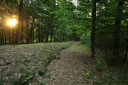
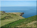
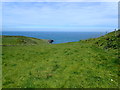
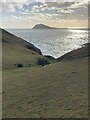
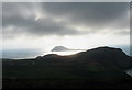
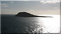
Bardsey Island (Ynys Enlli) lies 2 miles off the southern tip of the Lleyn Peninsula across Bardsey Sound or "Race of Bardsey". Known as a "Cradle of Celtic Christianity" since the 6th century, the Journal of Antiquities includes a page for this fascinating island - see their entry for Bardsey Island, Gwynedd, North Wales. The Journal tells us this has been a place of pilgrimage since medieval times, when "three pilgrimages to Bardsey Island were equal to one pilgrimage to Rome".
Whilst there are no remaining traces of the Celtic monastery evident today, remains of a tower of St Mary's Augustinian abbey (see Coflein NPRN 93544). In the ancient cemetery, which is still evident, there is a cross incised stone (see Coflein NPRN 93608) and a holy well (see Coflein NPRN 32186). The Coflein entry for the well states "(an) adjacent fallen stone indicates there was a superstructure of some sort".
On the island, there are also the remains of Neolithic roundhouses and a hermit's cave.
Note: Have you visited these sites? Do you have any photographs or information to add?
You may be viewing yesterday's version of this page. To see the most up to date information please register for a free account.
 (PID:241256)")
 (PID:241255)")
Do not use the above information on other web sites or publications without permission of the contributor.
Nearby Images from Geograph Britain and Ireland:
©2008(licence)
©2019(licence)
©2022(licence)
©2007(licence)
©2008(licence)
The above images may not be of the site on this page, they are loaded from Geograph.
Please Submit an Image of this site or go out and take one for us!
Click here to see more info for this site
Nearby sites
Key: Red: member's photo, Blue: 3rd party photo, Yellow: other image, Green: no photo - please go there and take one, Grey: site destroyed
Download sites to:
KML (Google Earth)
GPX (GPS waypoints)
CSV (Garmin/Navman)
CSV (Excel)
To unlock full downloads you need to sign up as a Contributory Member. Otherwise downloads are limited to 50 sites.
Turn off the page maps and other distractions
Nearby sites listing. In the following links * = Image available
3.3km NNE 29° Maen Melyn (Lleyn)* Standing Stone (Menhir) (SH1384625202)
3.4km NNE 31° St Mary's Well (Gwynedd)* Holy Well or Sacred Spring (SH13922518)
3.8km NNE 27° Mynydd Mawr Hut Group Ancient Village or Settlement (SH13942566)
5.8km NNE 33° Tynanelog Standing Stone* Standing Stone (Menhir) (SH155271)
6.2km NE 43° Ffynnon Saint (Minafon)* Holy Well or Sacred Spring (SH16532671)
6.6km NE 50° The Anelog Stones* Early Christian Sculptured Stone (SH173264)
7.4km ENE 64° Carreg Gybi Standing Stones (SH18852540)
7.5km NNE 25° Dinas Fawr Promontory Fort / Cliff Castle (SH15542907)
7.9km NNE 25° Dinas Bach (Carreg) Promontory Fort / Cliff Castle (SH15782937)
8.7km NNE 29° Porthor* Natural Stone / Erratic / Other Natural Feature (SH16542983)
8.9km NE 45° Castell Odo* Hillfort (SH187284)
9.8km NE 46° Ffynnon Ffol Holy Well or Sacred Spring (SH19402891)
9.9km ENE 61° St Maelrhys’ Church, Llanfaelrhys* Holy Well or Sacred Spring (SH21002683)
10.0km ENE 61° St Maelrhys’ Holy Well* Holy Well or Sacred Spring (SH21052683)
11.8km ENE 61° Capel Tan-Y-Foel* Standing Stone (Menhir) (SH22612767)
11.8km NE 52° Meillionydd double ringwork* Hillfort (SH21692924)
11.8km ENE 63° Mynydd y Graig* Hillfort (SH228274)
12.0km ENE 63° Tuhwnt-I'r-Mynyd Cairn (SH23062731)
12.3km NE 45° Maenhir Penygroeslon Standing Stone (Menhir) (SH21093079)
12.4km ENE 59° Rhiw fort* Ancient Village or Settlement (SH23002831)
12.5km ENE 60° Bronheulog* Burial Chamber or Dolmen (SH23192812)
12.8km ENE 59° Ffynnon Aelrhiw* Holy Well or Sacred Spring (SH23382847)
13.2km NE 55° Mynydd Rhiw South* Cairn (SH23242949)
13.3km NE 55° Mynydd Rhiw Cairn 1* Cairn (SH23262960)
13.3km ENE 59° Tan-Y-Muriau* Chambered Cairn (SH23772877)
View more nearby sites and additional images


 We would like to know more about this location. Please feel free to add a brief description and any relevant information in your own language.
 Wir möchten mehr über diese Stätte erfahren. Bitte zögern Sie nicht, eine kurze Beschreibung und relevante Informationen in Deutsch hinzuzufügen.
 Nous aimerions en savoir encore un peu sur les lieux. S'il vous plaît n'hesitez pas à ajouter une courte description et tous les renseignements pertinents dans votre propre langue.
 Quisieramos informarnos un poco más de las lugares. No dude en añadir una breve descripción y otros datos relevantes en su propio idioma.