


<< Our Photo Pages >> Constantine Island - Barrow Cemetery in England in Cornwall
Submitted by TheCaptain on Wednesday, 29 June 2022 Page Views: 614
Neolithic and Bronze AgeSite Name: Constantine IslandCountry: England
NOTE: This site is 0.4 km away from the location you searched for.
County: Cornwall Type: Barrow Cemetery
Nearest Town: Padstow Nearest Village: St Merryn
Map Ref: SW85727513
Latitude: 50.536594N Longitude: 5.025263W
Condition:
| 5 | Perfect |
| 4 | Almost Perfect |
| 3 | Reasonable but with some damage |
| 2 | Ruined but still recognisable as an ancient site |
| 1 | Pretty much destroyed, possibly visible as crop marks |
| 0 | No data. |
| -1 | Completely destroyed |
| 5 | Superb |
| 4 | Good |
| 3 | Ordinary |
| 2 | Not Good |
| 1 | Awful |
| 0 | No data. |
| 5 | Can be driven to, probably with disabled access |
| 4 | Short walk on a footpath |
| 3 | Requiring a bit more of a walk |
| 2 | A long walk |
| 1 | In the middle of nowhere, a nightmare to find |
| 0 | No data. |
| 5 | co-ordinates taken by GPS or official recorded co-ordinates |
| 4 | co-ordinates scaled from a detailed map |
| 3 | co-ordinates scaled from a bad map |
| 2 | co-ordinates of the nearest village |
| 1 | co-ordinates of the nearest town |
| 0 | no data |
Internal Links:
External Links:
I have visited· I would like to visit
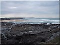
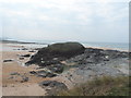
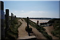
TheCaptain visited on 12th Jun 2022 - their rating: Cond: 2 Amb: 5 Access: 3 A long walk round Trevose Head starting at Constantine. I cross Constantine Beach, and climb up for a look on the islet between Constantine and Booby's beaches. Is this remains of a cairn? Moving on, I drop down into Booby's Bay, hoping to see the remnants of the S.V. Carl shipwreck, but the sands have covered most of it up again.
hevveh have visited here
")
From Cornish Archaeology, 2009-10, "Excavation of a Bronze Age barrow on Constantine Island, St Merryn, Cornwall", Andy M Jones.
"In August 2007, an inhumation burial was reported within a cist at the seaward end of Constantine Island, St Merryn. The National Trust commissioned the Historic Environment Service to undertake an archaeological excavation of the site (SW 85719 75122). The cist, which was found to hold a crouched adult male, was set within a cairn over an earlier small mound that was largely comprised of sand, stone and midden material. The mound in turn was found to overlay an earlier land surface. The site was not completely excavated but a section was cut across it so that its construction sequence and relationship with the cist could be better understood. A radiocarbon date on bone from the skeleton fell between 1380 and 1110 cal BC, providing a Middle Bronze date, a period from which very few human remains are known from Cornwall and no other barrow-associated burials are currently recorded.
See Excavation_of_a_Bronze_Age_barrow_on_Constantine_Island_St_Merryn_Cornwall
You may be viewing yesterday's version of this page. To see the most up to date information please register for a free account.
")
")
")
")
Do not use the above information on other web sites or publications without permission of the contributor.
Nearby Images from Geograph Britain and Ireland:
©2008(licence)
©2015(licence)
©2007(licence)
©2014(licence)
©2015(licence)
The above images may not be of the site on this page, they are loaded from Geograph.
Please Submit an Image of this site or go out and take one for us!
Click here to see more info for this site
Nearby sites
Key: Red: member's photo, Blue: 3rd party photo, Yellow: other image, Green: no photo - please go there and take one, Grey: site destroyed
Download sites to:
KML (Google Earth)
GPX (GPS waypoints)
CSV (Garmin/Navman)
CSV (Excel)
To unlock full downloads you need to sign up as a Contributory Member. Otherwise downloads are limited to 50 sites.
Turn off the page maps and other distractions
Nearby sites listing. In the following links * = Image available
806m E 100° St Constantine's Well* Holy Well or Sacred Spring (SW86517496)
1.3km NW 323° Dinas Head (Trevose)* Promontory Fort / Cliff Castle (SW84987621)
1.3km S 191° Winecove Point N* Promontory Fort / Cliff Castle (SW85427382)
1.4km NW 317° Dinas Head Tumulus* Round Barrow(s) (SW84847616)
1.5km S 190° Winecove Point mid* Promontory Fort / Cliff Castle (SW85427371)
1.6km S 188° Winecove Point S* Promontory Fort / Cliff Castle (SW85447358)
1.7km NE 54° Cataclews Point Tumuli* Barrow Cemetery (SW87167610)
2.0km E 80° Harlyn Bay* Barrow Cemetery (SW877754)
2.8km E 92° St Cadoc's Well Holy Well or Sacred Spring (SW885749)
3.9km SSE 166° Porthcothan Cave* Cave or Rock Shelter (SW865713)
4.2km ESE 112° The Stones, Tresallyn Cross* Modern Stone Circle etc (SW89587340)
4.6km SSW 198° Park Head Fort* Promontory Fort / Cliff Castle (SW84157080)
5.0km S 176° Treburrick menhir* Standing Stone (Menhir) (SW85867011)
5.5km S 186° Redcliff Castle* Promontory Fort / Cliff Castle (SW84926965)
5.7km E 84° Fenton Luna* Holy Well or Sacred Spring (SW91477554)
5.8km E 85° Padstow Cross* Ancient Cross (SW91577539)
5.9km E 85° Cross Shaft and Base at St Petroc's, Padstow.* Ancient Cross (SW91607538)
6.0km E 86° Ladywell (Padstow) Holy Well or Sacred Spring (SW91787535)
6.1km SSE 164° St Eval Church Stones* Standing Stones (SW87196916)
6.3km ENE 76° St George's Well (Padstow)* Holy Well or Sacred Spring (SW91887645)
6.4km S 186° Carnewas Longstone* Standing Stone (Menhir) (SW84756885)
6.5km ENE 58° St John's Well (Stepper Point)* Holy Well or Sacred Spring (SW914784)
7.2km SSE 166° St Eval Airport Stone* Standing Stone (Menhir) (SW87146803)
7.4km ENE 72° Brea Hill* Round Barrow(s) (SW92847714)
7.7km ENE 72° St Enodoc Church Cross* Ancient Cross (SW93157722)
View more nearby sites and additional images


 We would like to know more about this location. Please feel free to add a brief description and any relevant information in your own language.
 Wir möchten mehr über diese Stätte erfahren. Bitte zögern Sie nicht, eine kurze Beschreibung und relevante Informationen in Deutsch hinzuzufügen.
 Nous aimerions en savoir encore un peu sur les lieux. S'il vous plaît n'hesitez pas à ajouter une courte description et tous les renseignements pertinents dans votre propre langue.
 Quisieramos informarnos un poco más de las lugares. No dude en añadir una breve descripción y otros datos relevantes en su propio idioma.