<< Our Photo Pages >> Carn Ban (Carnasserie) - Cairn in Scotland in Argyll
Submitted by SolarMegalith on Wednesday, 08 May 2013 Page Views: 2680
Neolithic and Bronze AgeSite Name: Carn Ban (Carnasserie)Country: Scotland County: Argyll Type: Cairn
Nearest Village: Kilmartin
Map Ref: NM8411101503
Latitude: 56.157173N Longitude: 5.477958W
Condition:
| 5 | Perfect |
| 4 | Almost Perfect |
| 3 | Reasonable but with some damage |
| 2 | Ruined but still recognisable as an ancient site |
| 1 | Pretty much destroyed, possibly visible as crop marks |
| 0 | No data. |
| -1 | Completely destroyed |
| 5 | Superb |
| 4 | Good |
| 3 | Ordinary |
| 2 | Not Good |
| 1 | Awful |
| 0 | No data. |
| 5 | Can be driven to, probably with disabled access |
| 4 | Short walk on a footpath |
| 3 | Requiring a bit more of a walk |
| 2 | A long walk |
| 1 | In the middle of nowhere, a nightmare to find |
| 0 | No data. |
| 5 | co-ordinates taken by GPS or official recorded co-ordinates |
| 4 | co-ordinates scaled from a detailed map |
| 3 | co-ordinates scaled from a bad map |
| 2 | co-ordinates of the nearest village |
| 1 | co-ordinates of the nearest town |
| 0 | no data |
Internal Links:
External Links:
I have visited· I would like to visit
SolarMegalith saw from a distance on 29th Apr 2013 - their rating: Cond: 4
 (PID:107225)")
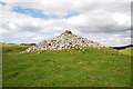
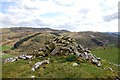
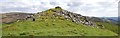
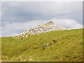
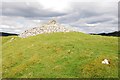
This large Bronze Age cairn is located on the summit of a ridge, a dominating position over surrounding landscape. The monument is in good condition, it has 20m in diameter and is 3m high, some of the kerbstones on its perimeter are still in situ.
Reference:
2008. "Kilmartin: An Inventory of the Monuments Extracted from Argyll", RCAHMS, p. 25.
You may be viewing yesterday's version of this page. To see the most up to date information please register for a free account.
 (PID:107224)")
Do not use the above information on other web sites or publications without permission of the contributor.
Nearby Images from Geograph Britain and Ireland:
©2014(licence)
©2014(licence)
©2014(licence)
©2014(licence)
©2014(licence)
The above images may not be of the site on this page, they are loaded from Geograph.
Please Submit an Image of this site or go out and take one for us!
Click here to see more info for this site
Nearby sites
Key: Red: member's photo, Blue: 3rd party photo, Yellow: other image, Green: no photo - please go there and take one, Grey: site destroyed
Download sites to:
KML (Google Earth)
GPX (GPS waypoints)
CSV (Garmin/Navman)
CSV (Excel)
To unlock full downloads you need to sign up as a Contributory Member. Otherwise downloads are limited to 50 sites.
Turn off the page maps and other distractions
Nearby sites listing. In the following links * = Image available
376m SE 129° Carnasserie Farm* Rock Art (NM84390125)
682m SSW 196° Carnasserie Rock Art* Rock Art (NM8389100856)
963m SW 220° Carnasserie Stones* Standing Stones (NM8345400796)
1.0km S 189° Carnasserie, Kist* Cist (NM83910051)
1.1km SW 218° Carnasserie Cairn* Cairn (NM8338900679)
1.5km ESE 102° Glennan Cairn* Cairn (NM856011)
1.5km NNE 28° Dun Na Nighinn Stone Fort or Dun (NM84910282)
1.6km ESE 102° Creagantairbh Beag Cairns* Cairn (NM85670108)
1.6km NE 54° Creag A Chapuill* Stone Fort or Dun (NM855024)
1.7km E 100° Glennan Standing Stone* Standing Stone (Menhir) (NM85730112)
1.8km E 85° Creagantairbh Beag* Standing Stone (Menhir) (NM85950156)
1.9km SW 229° Dun Mac Samhainn Cairn (NM826003)
2.2km WNW 299° Ormaig* Rock Art (NM82220267)
2.4km SSW 202° Upper Largie Burial Chamber or Dolmen (NR831993)
2.5km N 356° Salachary* Stone Row / Alignment (NM8405604024)
2.5km NNE 29° Dun Chonallaich* Stone Fort or Dun (NM85440365)
2.7km SSW 195° Glebe Cairn* Cairn (NR8330098930)
2.7km SSW 192° Kilmartin House* Museum (NR8343298890)
2.7km S 191° Kilmartin Churchyard* Sculptured Stone (NR8345998859)
2.7km NNW 333° Bealoch Mor Stone Circle (NM8304)
2.7km S 191° Kilmartin Churchyard (Poltalloch Enclosure)* Sculptured Stone (NR8346798842)
2.7km S 191° Kilmartin Churchyard (Lapidarium)* Sculptured Stone (NR8344898839)
2.8km ENE 66° Loch Ederline* Crannog (NM867025)
2.8km NW 322° Lochan Druim An Rathaid Cairn (NM825038)
3.1km NE 52° Ford Stone (Kilmartin)* Standing Stone (Menhir) (NM8668103317)
View more nearby sites and additional images


 We would like to know more about this location. Please feel free to add a brief description and any relevant information in your own language.
 Wir möchten mehr über diese Stätte erfahren. Bitte zögern Sie nicht, eine kurze Beschreibung und relevante Informationen in Deutsch hinzuzufügen.
 Nous aimerions en savoir encore un peu sur les lieux. S'il vous plaît n'hesitez pas à ajouter une courte description et tous les renseignements pertinents dans votre propre langue.
 Quisieramos informarnos un poco más de las lugares. No dude en añadir una breve descripción y otros datos relevantes en su propio idioma.