

<< Our Photo Pages >> Bishops Wood Fort - Hillfort in England in Cornwall
Submitted by Bladup on Saturday, 29 August 2020 Page Views: 3924
Iron Age and Later PrehistorySite Name: Bishops Wood FortCountry: England
NOTE: This site is 1.4 km away from the location you searched for.
County: Cornwall Type: Hillfort
Nearest Town: Truro
Map Ref: SW82914873
Latitude: 50.298477N Longitude: 5.049583W
Condition:
| 5 | Perfect |
| 4 | Almost Perfect |
| 3 | Reasonable but with some damage |
| 2 | Ruined but still recognisable as an ancient site |
| 1 | Pretty much destroyed, possibly visible as crop marks |
| 0 | No data. |
| -1 | Completely destroyed |
| 5 | Superb |
| 4 | Good |
| 3 | Ordinary |
| 2 | Not Good |
| 1 | Awful |
| 0 | No data. |
| 5 | Can be driven to, probably with disabled access |
| 4 | Short walk on a footpath |
| 3 | Requiring a bit more of a walk |
| 2 | A long walk |
| 1 | In the middle of nowhere, a nightmare to find |
| 0 | No data. |
| 5 | co-ordinates taken by GPS or official recorded co-ordinates |
| 4 | co-ordinates scaled from a detailed map |
| 3 | co-ordinates scaled from a bad map |
| 2 | co-ordinates of the nearest village |
| 1 | co-ordinates of the nearest town |
| 0 | no data |
Internal Links:
External Links:
I have visited· I would like to visit
LiveAndrew would like to visit
lucasn visited on 20th May 2022 - their rating: Cond: 4 Amb: 4 Access: 3
")
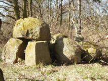
The earthwork remains of a large Iron Age univallate hillfort in Bishop's Wood. The hillfort is roughly oval in plan and measures approximately 170 metres by 143 metres. The earth and stone rampart is between 6.8 to 9.4 metres wide, 1.8 metres deep on the inside and between 2.5 and 3 metres high outside. The external ditch around 4.5 metres wide at the top, 2.5 metres wide at its base and 2 metres deep. The original entrances on the west and south east sides survive as gaps in the rampart.
You may be viewing yesterday's version of this page. To see the most up to date information please register for a free account.
")
")
")
")
")
")
")
")
")
")
")
")
")
")
")
")
")
")
")
Do not use the above information on other web sites or publications without permission of the contributor.
Click here to see more info for this site
Nearby sites
Key: Red: member's photo, Blue: 3rd party photo, Yellow: other image, Green: no photo - please go there and take one, Grey: site destroyed
Download sites to:
KML (Google Earth)
GPX (GPS waypoints)
CSV (Garmin/Navman)
CSV (Excel)
To unlock full downloads you need to sign up as a Contributory Member. Otherwise downloads are limited to 50 sites.
Turn off the page maps and other distractions
Nearby sites listing. In the following links * = Image available
1.0km W 281° Garras Round* Ancient Village or Settlement (SW81914897)
1.2km NW 322° Lanner Wood Round* Ancient Village or Settlement (SW82194974)
2.0km NNW 337° St Allen Crosses* Ancient Cross (SW822506)
3.0km SSE 160° Truro Eastern District Centre Neolithic Enclosure* Causewayed Enclosure (SW838459)
3.1km SSW 197° Kenwyn* Holy Well or Sacred Spring (SW819458)
3.7km ENE 63° Tregear (St Erme) Round Ancient Village or Settlement (SW86305031)
3.8km SSW 191° St Domnu's Well* Holy Well or Sacred Spring (SW820450)
3.8km S 184° Truro Cathedral Celtic Cross* Early Christian Sculptured Stone (SW825449)
4.0km S 185° Royal Cornwall Museum* Museum (SW824448)
4.4km SW 230° Penventinnie Round* Ancient Village or Settlement (SW79374603)
4.5km W 278° Tresawsen Round Ancient Village or Settlement (SW78424954)
4.7km NW 326° Engelly Round Ancient Village or Settlement (SW80465269)
5.0km N 8° Carland Cross Henge Henge (SW83825370)
5.3km WSW 239° Bosvisack Round* Hillfort (SW78254624)
5.3km SSE 153° Ignioc Stone* Ancient Cross (SW851439)
5.4km NNE 16° Warren's Barrow* Barrow Cemetery (SW846539)
5.5km SSE 152° St Clement's Well* Holy Well or Sacred Spring (SW853438)
5.7km SSE 159° Malpas Tumulus* Round Barrow(s) (SW848433)
6.0km ESE 109° Trelowthas Cross* Ancient Cross (SW885466)
6.0km ENE 65° Penhale Round Ancient Village or Settlement (SW88485102)
6.0km NW 306° Caer Kief* Ancient Village or Settlement (SW782525)
6.2km WNW 301° Caer Dane* Ancient Village or Settlement (SW777522)
6.3km WNW 284° Callestock Veor Round Ancient Village or Settlement (SW76875053)
6.7km W 263° Kenwyn Four Burrows* Barrow Cemetery (SW762482)
6.9km SSW 213° Gooderne Round Ancient Village or Settlement (SW78954307)
View more nearby sites and additional images


 We would like to know more about this location. Please feel free to add a brief description and any relevant information in your own language.
 Wir möchten mehr über diese Stätte erfahren. Bitte zögern Sie nicht, eine kurze Beschreibung und relevante Informationen in Deutsch hinzuzufügen.
 Nous aimerions en savoir encore un peu sur les lieux. S'il vous plaît n'hesitez pas à ajouter une courte description et tous les renseignements pertinents dans votre propre langue.
 Quisieramos informarnos un poco más de las lugares. No dude en añadir una breve descripción y otros datos relevantes en su propio idioma.