<< Text Pages >> Dun Rostan - Stone Fort or Dun in Scotland in Argyll
Submitted by SolarMegalith on Saturday, 11 August 2012 Page Views: 2822
Multi-periodSite Name: Dun RostanCountry: Scotland County: Argyll Type: Stone Fort or Dun
Map Ref: NR73628097
Latitude: 55.968200N Longitude: 5.629156W
Condition:
| 5 | Perfect |
| 4 | Almost Perfect |
| 3 | Reasonable but with some damage |
| 2 | Ruined but still recognisable as an ancient site |
| 1 | Pretty much destroyed, possibly visible as crop marks |
| 0 | No data. |
| -1 | Completely destroyed |
| 5 | Superb |
| 4 | Good |
| 3 | Ordinary |
| 2 | Not Good |
| 1 | Awful |
| 0 | No data. |
| 5 | Can be driven to, probably with disabled access |
| 4 | Short walk on a footpath |
| 3 | Requiring a bit more of a walk |
| 2 | A long walk |
| 1 | In the middle of nowhere, a nightmare to find |
| 0 | No data. |
| 5 | co-ordinates taken by GPS or official recorded co-ordinates |
| 4 | co-ordinates scaled from a detailed map |
| 3 | co-ordinates scaled from a bad map |
| 2 | co-ordinates of the nearest village |
| 1 | co-ordinates of the nearest town |
| 0 | no data |
Internal Links:
External Links:
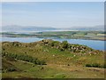
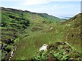
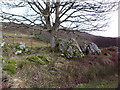
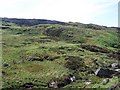
Dun in Argyll
A galleried dun with preserved outer wall-face and the entrance with distinguishable bar-holes and door-checks. At the NE and SE there are two additional rubble walls.
Read More at Canmore.
You may be viewing yesterday's version of this page. To see the most up to date information please register for a free account.
Do not use the above information on other web sites or publications without permission of the contributor.
Nearby Images from Geograph Britain and Ireland:
©2008(licence)
©2008(licence)
©2013(licence)
©2008(licence)

©2025(licence)
The above images may not be of the site on this page, they are loaded from Geograph.
Please Submit an Image of this site or go out and take one for us!
Click here to see more info for this site
Nearby sites
Key: Red: member's photo, Blue: 3rd party photo, Yellow: other image, Green: no photo - please go there and take one, Grey: site destroyed
Download sites to:
KML (Google Earth)
GPX (GPS waypoints)
CSV (Garmin/Navman)
CSV (Excel)
To unlock full downloads you need to sign up as a Contributory Member. Otherwise downloads are limited to 50 sites.
Turn off the page maps and other distractions
Nearby sites listing. In the following links * = Image available
4.5km SSE 158° St Columba's Cave* Cave or Rock Shelter (NR751767)
5.1km ESE 123° Achahoish* Standing Stone (Menhir) (NR7773778016)
5.2km NNW 348° Upper Fernoch* Standing Stone (Menhir) (NR72808613)
5.5km N 350° Barnashaig* Standing Stone (Menhir) (NR72988640)
5.7km ESE 117° Caisteal Torr Stone Fort or Dun (NR78567807)
6.6km SSW 207° Kilmory Knap* Sculptured Stone (NR703752)
10.2km NNE 22° Holy Well (Kilmory Oib)* Holy Well or Sacred Spring (NR780902)
10.7km NNE 26° Gartnagreanoch* Chambered Cairn (NR789903)
10.8km NNE 23° Kilmory Oib Enclosure* Standing Stones (NR78289070)
13.0km W 273° Tarbert (Jura)* Standing Stone (Menhir) (NR6062782298)
13.1km S 188° Dun Cragach Stone Fort or Dun (NR71086805)
13.6km NE 36° Barnakill Rock Art (NR82199154)
13.9km NNE 20° Crinan Woods Cup Stone* Rock Art (NR79019382)
14.2km NE 44° Carn Ban (Lochgilphead)* Cairn (NR840907)
14.2km ENE 64° Kilmory Castle Standing Stone* Standing Stone (Menhir) (NR8673986524)
14.2km NNW 335° Cnoc a' Chuirn Moir (Jura) Cairn (NR68299421)
14.3km NE 42° Cairnbaan 2* Rock Art (NR8387791056)
14.4km S 189° Cretshengan* Standing Stone (Menhir) (NR70726689)
14.4km NE 43° Cairnbaan 1* Rock Art (NR8398891027)
14.5km NE 43° Dun Chuain* Stone Fort or Dun (NR841910)
14.9km NE 50° Achnabreac* Standing Stones (NR85638992)
14.9km NNE 26° Crinan Moss Stones* Standing Stones (NR80839409)
15.0km NNE 26° Crinan Moss Cairn Cairn (NR80909408)
15.0km NE 49° Achnabreck Stone* Standing Stone (Menhir) (NR8553790197)
15.1km NE 47° Dun Na Maraig* Stone Fort or Dun (NR85259072)
View more nearby sites and additional images


 We would like to know more about this location. Please feel free to add a brief description and any relevant information in your own language.
 Wir möchten mehr über diese Stätte erfahren. Bitte zögern Sie nicht, eine kurze Beschreibung und relevante Informationen in Deutsch hinzuzufügen.
 Nous aimerions en savoir encore un peu sur les lieux. S'il vous plaît n'hesitez pas à ajouter une courte description et tous les renseignements pertinents dans votre propre langue.
 Quisieramos informarnos un poco más de las lugares. No dude en añadir una breve descripción y otros datos relevantes en su propio idioma.