<< Text Pages >> North Ronan Crosses - Ancient Cross in Scotland in Isle of Lewis
Submitted by kaiHofmann on Tuesday, 27 January 2015 Page Views: 2427
Early Medieval (Dark Age)Site Name: North Ronan CrossesCountry: Scotland
NOTE: This site is 24.1 km away from the location you searched for.
County: Isle of Lewis Type: Ancient Cross
Nearest Village: North Rona Island
Map Ref: HW80913231
Latitude: 59.121008N Longitude: 5.82984W
Condition:
| 5 | Perfect |
| 4 | Almost Perfect |
| 3 | Reasonable but with some damage |
| 2 | Ruined but still recognisable as an ancient site |
| 1 | Pretty much destroyed, possibly visible as crop marks |
| 0 | No data. |
| -1 | Completely destroyed |
| 5 | Superb |
| 4 | Good |
| 3 | Ordinary |
| 2 | Not Good |
| 1 | Awful |
| 0 | No data. |
| 5 | Can be driven to, probably with disabled access |
| 4 | Short walk on a footpath |
| 3 | Requiring a bit more of a walk |
| 2 | A long walk |
| 1 | In the middle of nowhere, a nightmare to find |
| 0 | No data. |
| 5 | co-ordinates taken by GPS or official recorded co-ordinates |
| 4 | co-ordinates scaled from a detailed map |
| 3 | co-ordinates scaled from a bad map |
| 2 | co-ordinates of the nearest village |
| 1 | co-ordinates of the nearest town |
| 0 | no data |
Be the first person to rate this site - see the 'Contribute!' box in the right hand menu.
Internal Links:
External Links:
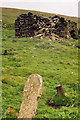
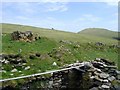
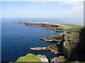
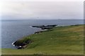
Ancient Crosses in North Rona, a small Island of the Outer Hebrides
Two early medieval crosses of the 8th century. An early medieval chapel of St. Ronan is located nearby. The site is located on North Rona a small Island of the Outer Hebrides.
Canmore ID 319424
You may be viewing yesterday's version of this page. To see the most up to date information please register for a free account.
Do not use the above information on other web sites or publications without permission of the contributor.
Nearby Images from Geograph Britain and Ireland:
©2005(licence)
©2008(licence)
©2009(licence)
©2017(licence)
©2008(licence)
The above images may not be of the site on this page, they are loaded from Geograph.
Please Submit an Image of this site or go out and take one for us!
Click here to see more info for this site
Nearby sites
Key: Red: member's photo, Blue: 3rd party photo, Yellow: other image, Green: no photo - please go there and take one, Grey: site destroyed
Download sites to:
KML (Google Earth)
GPX (GPS waypoints)
CSV (Garmin/Navman)
CSV (Excel)
To unlock full downloads you need to sign up as a Contributory Member. Otherwise downloads are limited to 50 sites.
Turn off the page maps and other distractions
Nearby sites listing. In the following links * = Image available
72.6km SSW 199° Dùn Èistean* Ancient Village or Settlement (NB5349164962)
73.3km SSW 199° Clach Stein* Standing Stones (NB5348764187)
81.3km SSW 203° Dun Sabhuill Stone Fort or Dun (NB44305956)
84.7km SSW 205° Tobar Bhrìghde* Holy Well or Sacred Spring (NB41035738)
87.1km SE 135° Balnakeil Stone Circle* Stone Circle (NC392673)
87.8km SSW 205° Clach Stei Lin* Stone Circle (NB3969454546)
88.2km SSW 205° Loch an Dùin (Shader)* Broch or Nuraghe (NB39295435)
88.2km SSW 205° Steinacleit* Chambered Tomb (NB39635408)
88.5km SE 137° Sarsgrum* Cairn (NC37926435)
89.0km SE 134° Smoo Cave* Cave or Rock Shelter (NC4188367123)
89.0km SE 138° Kyle of Durness Cairn* Round Cairn (NC37336312)
89.3km SE 139° River Dionard Broch or Nuraghe (NC36336200)
89.5km SSW 206° Clach An Truishal* Standing Stone (Menhir) (NB3756053775)
89.5km SE 138° Ach A' Chorrain Chambered Cairn Chambered Cairn (NC37156233)
89.9km SE 139° Ach A' Chorrain Cairn* Cairn (NC36656149)
92.7km SE 137° Kyle of Durness Wheelhouse* Broch or Nuraghe (NC4048761009)
93.0km SSW 195° Dun Beinn Earba Stone Fort or Dun (NB518438)
93.9km SSW 196° Dun Beinn Ivor Stone Fort or Dun (NB495436)
94.0km SE 136° Laid Souterrain (Fogou, Earth House) (NC42816126)
94.3km SSW 207° Barabhas* Modern Stone Circle etc (NB333506)
94.5km SSW 198° Carn A' Mharc Chambered Cairn (NB4722543846)
94.6km SSE 151° Badnabay* Chambered Cairn (NC218468)
96.1km SSE 155° Cnoc An Daimh* Chambered Cairn (NC1667342937)
96.3km SE 136° Dun Neachdie Broch or Nuraghe (NC446597)
96.3km SE 135° Heilam Hut Circle (4) Cairn (NC45426042)
View more nearby sites and additional images


 We would like to know more about this location. Please feel free to add a brief description and any relevant information in your own language.
 Wir möchten mehr über diese Stätte erfahren. Bitte zögern Sie nicht, eine kurze Beschreibung und relevante Informationen in Deutsch hinzuzufügen.
 Nous aimerions en savoir encore un peu sur les lieux. S'il vous plaît n'hesitez pas à ajouter une courte description et tous les renseignements pertinents dans votre propre langue.
 Quisieramos informarnos un poco más de las lugares. No dude en añadir una breve descripción y otros datos relevantes en su propio idioma.