

<< Our Photo Pages >> Drift Stones - Standing Stones in England in Cornwall
Submitted by thecaptain on Friday, 26 August 2016 Page Views: 17471
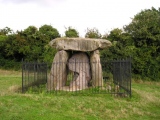
Neolithic and Bronze AgeSite Name: Drift Stones Alternative Name: The Sisters, Triganeeris Stones, Higher Drift Menhirs, #NoRTRCountry: England County: Cornwall Type: Standing Stones
Nearest Town: Penzance Nearest Village: Drift
Map Ref: SW43712831 Landranger Map Number: 203
Latitude: 50.099464N Longitude: 5.58517W
Condition:
| 5 | Perfect |
| 4 | Almost Perfect |
| 3 | Reasonable but with some damage |
| 2 | Ruined but still recognisable as an ancient site |
| 1 | Pretty much destroyed, possibly visible as crop marks |
| 0 | No data. |
| -1 | Completely destroyed |
| 5 | Superb |
| 4 | Good |
| 3 | Ordinary |
| 2 | Not Good |
| 1 | Awful |
| 0 | No data. |
| 5 | Can be driven to, probably with disabled access |
| 4 | Short walk on a footpath |
| 3 | Requiring a bit more of a walk |
| 2 | A long walk |
| 1 | In the middle of nowhere, a nightmare to find |
| 0 | No data. |
| 5 | co-ordinates taken by GPS or official recorded co-ordinates |
| 4 | co-ordinates scaled from a detailed map |
| 3 | co-ordinates scaled from a bad map |
| 2 | co-ordinates of the nearest village |
| 1 | co-ordinates of the nearest town |
| 0 | no data |
Internal Links:
External Links:
I have visited· I would like to visit
markj99 visited on 19th Mar 2013 - their rating: Cond: 5 Amb: 4 Access: 4 It is easy to park in a lay-by off the A30 at SW 4372 2837, c. 100 yards SW of the 30 mph limit on the SW of Drift. The Drift Stones are a well matched pair of tall standing stones easily accessed by a gateway if the field is not in crop.
Andy B visited #12 in our rundown of favourite standing stones (and pairs) in Britain
lucasn visited - their rating: Cond: 5 Amb: 4 Access: 5
Humbucker Bladup TheCaptain AngieLake davidmorgan hamish sem TimPrevett kernowek ArchAstro cazzyjane have visited here
Average ratings for this site from all visit loggers: Condition: 5 Ambience: 4 Access: 4.5
")
The larger of the two stones, which is the farthest from the road, is said to resemble a lady wearing a cloak, and I can vouch that from certain angles this does indeed look the case.
Access: The Sisters can be seen from the A30. There is a handy lay-by and easy access through the field, where they stand less than 100 yards from the gate.
You may be viewing yesterday's version of this page. To see the most up to date information please register for a free account.
")
")
")
")
")
")
")
")
")
")
")
")
")
")
")
")
")
")
")
")
")
")
")
")
These are just the first 25 photos of Drift Stones. If you log in with a free user account you will be able to see our entire collection.
Do not use the above information on other web sites or publications without permission of the contributor.
Click here to see more info for this site
Nearby sites
Key: Red: member's photo, Blue: 3rd party photo, Yellow: other image, Green: no photo - please go there and take one, Grey: site destroyed
Download sites to:
KML (Google Earth)
GPX (GPS waypoints)
CSV (Garmin/Navman)
CSV (Excel)
To unlock full downloads you need to sign up as a Contributory Member. Otherwise downloads are limited to 50 sites.
Turn off the page maps and other distractions
Nearby sites listing. In the following links * = Image available
441m N 2° Lower Drift Cross* Ancient Cross (SW43752875)
561m ESE 104° Tresvennack 2* Standing Stone (Menhir) (SW44252815)
642m SE 130° Tresvennack Pillar* Standing Stone (Menhir) (SW44182787)
939m ESE 106° Tresvennack Tumulus* Round Barrow(s) (SW446280)
942m E 93° Ennis Farm Standing Stone* Standing Stone (Menhir) (SW44652821)
1.1km NE 52° Buryas Bridge menhir* Standing Stone (Menhir) (SW4459928947)
1.1km SE 140° Kerris Menhir* Standing Stone (Menhir) (SW44392742)
1.1km SW 230° Trenuggo Cross* Ancient Cross (SW42802763)
1.2km W 261° Blind Fiddler* Standing Stone (Menhir) (SW42532819)
1.3km E 92° Chyenhal Settlement Ancient Village or Settlement (SW450282)
1.3km SSE 151° Kerris Spiral Stone* Carving (SW44292714)
1.3km SSE 149° Kerris Crosses* Ancient Cross (SW44332716)
1.4km SSW 204° Bojewans Carn* Natural Stone / Erratic / Other Natural Feature (SW431271)
1.4km N 7° Trewidden Round* Ancient Village or Settlement (SW43952967)
1.4km SE 144° Kerris Settlement* Ancient Village or Settlement (SW445271)
1.5km NE 52° Trembath Cross* Ancient Cross (SW4489229156)
1.5km E 91° Faughan* Standing Stones (SW45222822)
1.6km ESE 118° Chyenhal* Standing Stone (Menhir) (SW45062751)
1.9km SSW 210° Toldavas* Standing Stone (Menhir) (SW42662671)
1.9km W 279° Anjarden Spring* Holy Well or Sacred Spring (SW418287)
2.0km WNW 299° Sancreed Church* Ancient Cross (SW4202229349)
2.0km SE 144° Redhouse* Standing Stones (SW44802663)
2.0km NE 47° Paul Downs Cross* Ancient Cross (SW45252963)
2.0km WNW 284° Boswarthen Holed Stone* Holed Stone (SW41752890)
2.1km WSW 251° Boscawen-Un Hedge* Standing Stone (Menhir) (SW41732772)
View more nearby sites and additional images


 We would like to know more about this location. Please feel free to add a brief description and any relevant information in your own language.
 Wir möchten mehr über diese Stätte erfahren. Bitte zögern Sie nicht, eine kurze Beschreibung und relevante Informationen in Deutsch hinzuzufügen.
 Nous aimerions en savoir encore un peu sur les lieux. S'il vous plaît n'hesitez pas à ajouter une courte description et tous les renseignements pertinents dans votre propre langue.
 Quisieramos informarnos un poco más de las lugares. No dude en añadir una breve descripción y otros datos relevantes en su propio idioma.