<< Other Photo Pages >> Boscawen Ros Holed Stone - Holed Stone in England in Cornwall
Submitted by Bladup on Monday, 25 September 2023 Page Views: 349
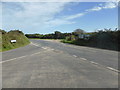
Neolithic and Bronze AgeSite Name: Boscawen Ros Holed StoneCountry: England County: Cornwall Type: Holed Stone
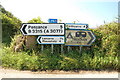
Nearest Town: Penzance Nearest Village: St.Buryan
Map Ref: SW42772421
Latitude: 50.062256N Longitude: 5.59553W
Condition:
| 5 | Perfect |
| 4 | Almost Perfect |
| 3 | Reasonable but with some damage |
| 2 | Ruined but still recognisable as an ancient site |
| 1 | Pretty much destroyed, possibly visible as crop marks |
| 0 | No data. |
| -1 | Completely destroyed |
| 5 | Superb |
| 4 | Good |
| 3 | Ordinary |
| 2 | Not Good |
| 1 | Awful |
| 0 | No data. |
| 5 | Can be driven to, probably with disabled access |
| 4 | Short walk on a footpath |
| 3 | Requiring a bit more of a walk |
| 2 | A long walk |
| 1 | In the middle of nowhere, a nightmare to find |
| 0 | No data. |
| 5 | co-ordinates taken by GPS or official recorded co-ordinates |
| 4 | co-ordinates scaled from a detailed map |
| 3 | co-ordinates scaled from a bad map |
| 2 | co-ordinates of the nearest village |
| 1 | co-ordinates of the nearest town |
| 0 | no data |
Internal Links:
External Links:
")
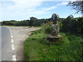
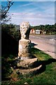
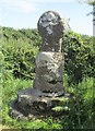
A holed stone found on the North Eastern side of the wall at SW42772421, It's 112cm x 110cm in length and 31cm in depth, The hole is 23cm wide
You may be viewing yesterday's version of this page. To see the most up to date information please register for a free account.
Do not use the above information on other web sites or publications without permission of the contributor.
Nearby Images from Geograph Britain and Ireland:
©2008(licence)
©2017(licence)
©2005(licence)
©2019(licence)
©2017(licence)
The above images may not be of the site on this page, they are loaded from Geograph.
Please Submit an Image of this site or go out and take one for us!
Click here to see more info for this site
Nearby sites
Key: Red: member's photo, Blue: 3rd party photo, Yellow: other image, Green: no photo - please go there and take one, Grey: site destroyed
Download sites to:
KML (Google Earth)
GPX (GPS waypoints)
CSV (Garmin/Navman)
CSV (Excel)
To unlock full downloads you need to sign up as a Contributory Member. Otherwise downloads are limited to 50 sites.
Turn off the page maps and other distractions
Nearby sites listing. In the following links * = Image available
186m WNW 283° Boskenna Cross* Ancient Cross (SW42592426)
229m E 90° Boskenna Tumuli* Barrow Cemetery (SW430242)
274m SSE 167° Boscawen-Ros East* Standing Stone (Menhir) (SW42822394)
278m S 176° Boscawen-Ros West* Standing Stone (Menhir) (SW4277423932)
310m NNE 30° Gun Rith* Standing Stone (Menhir) (SW42942447)
347m NE 48° Tregiffian Barrow* Chambered Tomb (SW43042443)
380m ENE 57° Merry Maidens SW Stone Circle (SW431244)
576m ENE 57° Merry Maidens (Circle)* Stone Circle (SW43272450)
613m NE 50° Merry Maidens Holed Stone* Holed Stone (SW43262458)
648m NE 50° Nun Careg Cross* Ancient Cross (SW43292460)
720m NE 44° The Pipers barrow* Round Cairn (SW433247)
727m ENE 62° Barnatt's Stone* Standing Stone (Menhir) (SW43432452)
751m NW 307° Chyoone Cross* Ancient Cross (SW42192469)
867m W 267° Boskenna Crosses* Early Christian Sculptured Stone (SW419242)
938m NE 49° Pipers (nr Merry Maidens)* Standing Stones (SW43512479)
1.1km ENE 71° Tregurnow* Stone Circle (SW4381824523)
1.1km NE 49° Boleigh Holed Stone* Holed Stone (SW43642490)
1.1km E 83° New Town Cross* Early Christian Sculptured Stone (SW439243)
1.2km ENE 57° New Town Tumulus* Round Barrow(s) (SW438248)
1.2km ENE 59° New Town Standing Stone* Standing Stone (Menhir) (SW43832478)
1.4km NE 40° Boleigh* Souterrain (Fogou, Earth House) (SW43712521)
1.5km E 91° Mên Frith* Holed Stone (SW44282411)
1.7km N 350° Vellansaga Cross* Ancient Cross (SW42552585)
2.0km W 261° Treverven Standing Stone* Standing Stone (Menhir) (SW4082323992)
2.0km NNE 25° Bellowal Farm Mound* Misc. Earthwork (SW437260)
View more nearby sites and additional images


 We would like to know more about this location. Please feel free to add a brief description and any relevant information in your own language.
 Wir möchten mehr über diese Stätte erfahren. Bitte zögern Sie nicht, eine kurze Beschreibung und relevante Informationen in Deutsch hinzuzufügen.
 Nous aimerions en savoir encore un peu sur les lieux. S'il vous plaît n'hesitez pas à ajouter une courte description et tous les renseignements pertinents dans votre propre langue.
 Quisieramos informarnos un poco más de las lugares. No dude en añadir una breve descripción y otros datos relevantes en su propio idioma.