


<< Our Photo Pages >> Carn Galver 1 - Natural Stone / Erratic / Other Natural Feature in England in Cornwall
Submitted by DavidShepherd on Wednesday, 25 March 2020 Page Views: 1131
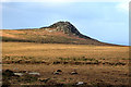
Natural PlacesSite Name: Carn Galver 1 Alternative Name: Dot's StoneCountry: England
NOTE: This site is 0.4 km away from the location you searched for.
County: Cornwall Type: Natural Stone / Erratic / Other Natural Feature
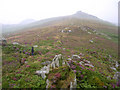
Nearest Town: St Ives Nearest Village: Rosemergy
Map Ref: SW4269236165
Latitude: 50.169528N Longitude: 5.604676W
Condition:
| 5 | Perfect |
| 4 | Almost Perfect |
| 3 | Reasonable but with some damage |
| 2 | Ruined but still recognisable as an ancient site |
| 1 | Pretty much destroyed, possibly visible as crop marks |
| 0 | No data. |
| -1 | Completely destroyed |
| 5 | Superb |
| 4 | Good |
| 3 | Ordinary |
| 2 | Not Good |
| 1 | Awful |
| 0 | No data. |
| 5 | Can be driven to, probably with disabled access |
| 4 | Short walk on a footpath |
| 3 | Requiring a bit more of a walk |
| 2 | A long walk |
| 1 | In the middle of nowhere, a nightmare to find |
| 0 | No data. |
| 5 | co-ordinates taken by GPS or official recorded co-ordinates |
| 4 | co-ordinates scaled from a detailed map |
| 3 | co-ordinates scaled from a bad map |
| 2 | co-ordinates of the nearest village |
| 1 | co-ordinates of the nearest town |
| 0 | no data |
Internal Links:
External Links:
I have visited· I would like to visit
micske visited on 1st Jul 2023 - their rating: Cond: 4 Amb: 5 Access: 3
LiveAndrew visited on 20th Jan 2022 - their rating: Cond: 5 Amb: 4 Access: 3
LiveAndrew visited on 24th Jun 2021 - their rating: Cond: 4 Amb: 5 Access: 3
Average ratings for this site from all visit loggers: Condition: 4.33 Ambience: 4.67 Access: 3
")
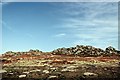
One prop and two points-of-contact.
There are linear grooves in the bedrock surface immediately south of the propped stone (1m long, 25mm wide and 10m deep). Their aetiology is unclear. The lower edge of the west face of the propped stone appeared to show some deckling – crescent-shaped absences possibly indicative of percussive shaping or of initial extraction using wood wedges. The prop showed a broad (25mm) horizontal band of quartz, there was no similar banding evident within a 100m search area. The long axis of the feature aligned with the general area of the Carn Galva tin mine; this, and the quartz-veined prop, might just be a reference to prehistoric surface extraction.
You may be viewing yesterday's version of this page. To see the most up to date information please register for a free account.
")
")
")
Do not use the above information on other web sites or publications without permission of the contributor.
Nearby Images from Geograph Britain and Ireland:
©2005(licence)
©2006(licence)
©2008(licence)
©2008(licence)

©2025(licence)
The above images may not be of the site on this page, they are loaded from Geograph.
Please Submit an Image of this site or go out and take one for us!
Click here to see more info for this site
Nearby sites
Key: Red: member's photo, Blue: 3rd party photo, Yellow: other image, Green: no photo - please go there and take one, Grey: site destroyed
Download sites to:
KML (Google Earth)
GPX (GPS waypoints)
CSV (Garmin/Navman)
CSV (Excel)
To unlock full downloads you need to sign up as a Contributory Member. Otherwise downloads are limited to 50 sites.
Turn off the page maps and other distractions
Nearby sites listing. In the following links * = Image available
169m SSE 164° Carn Galver* Ancient Village or Settlement (SW42733600)
216m SSE 150° Carn Galver 2* Natural Stone / Erratic / Other Natural Feature (SW4279235973)
245m S 180° Carn Galver* Round Barrow(s) (SW42683592)
303m WSW 241° White downs hut circle and pound* Ancient Village or Settlement (SW42423603)
563m SSE 147° Bosigran Barrows* Barrow Cemetery (SW42983568)
585m NNW 342° Bosigran Kerb Cairn* Cairn (SW42543673)
611m E 100° Little Galver Propped Stone* Natural Stone / Erratic / Other Natural Feature (SW43293603)
718m ENE 76° Hannibal's carn* Ancient Village or Settlement (SW434363)
751m SW 229° Watch Croft Standing Stone* Standing Stone (Menhir) (SW421357)
804m SSE 157° Four Parishes Rock* Sculptured Stone (SW42973541)
828m E 101° Carn Galver Cairn* Cairn (SW43503597)
856m NNW 344° Barsigran Farm Settlement and Homestead* Ancient Village or Settlement (SW425370)
864m S 177° Men Scryfa* Early Christian Sculptured Stone (SW42693530)
880m NW 311° Bosigran Settlement* Ancient Village or Settlement (SW42053677)
916m WSW 237° Watch Croft Cairns* Cairn (SW419357)
930m ESE 121° Little Galver Kerbcairns* Ring Cairn (SW43473565)
943m ENE 64° Bosporthennis Quoit* Burial Chamber or Dolmen (SW43563654)
986m SSE 165° Venton Bebibell* Holy Well or Sacred Spring (SW429352)
998m W 275° Rosemergy Stone Circle (SW417363)
1.0km SE 143° Boskednan A* Cairn (SW43273531)
1.0km SE 144° Boskednan Menhir 2* Standing Stone (Menhir) (SW43273529)
1.1km E 94° Bosporthennis Beehive Hut* Souterrain (Fogou, Earth House) (SW43773604)
1.1km SE 144° Boskednan B* Cairn (SW4329435260)
1.1km E 96° Bosporthennis 2* Ancient Village or Settlement (SW43793599)
1.1km NE 37° Porthmeor Fogou* Souterrain (Fogou, Earth House) (SW43413703)
View more nearby sites and additional images


 We would like to know more about this location. Please feel free to add a brief description and any relevant information in your own language.
 Wir möchten mehr über diese Stätte erfahren. Bitte zögern Sie nicht, eine kurze Beschreibung und relevante Informationen in Deutsch hinzuzufügen.
 Nous aimerions en savoir encore un peu sur les lieux. S'il vous plaît n'hesitez pas à ajouter une courte description et tous les renseignements pertinents dans votre propre langue.
 Quisieramos informarnos un poco más de las lugares. No dude en añadir una breve descripción y otros datos relevantes en su propio idioma.