 with our Megalithic Portal iPhone app")

<< Our Photo Pages >> Ardalanish - Standing Stones in Scotland in Isle of Mull
Submitted by SandyG on Tuesday, 08 October 2002 Page Views: 8212
Neolithic and Bronze AgeSite Name: ArdalanishCountry: Scotland
NOTE: This site is 2.4 km away from the location you searched for.
County: Isle of Mull Type: Standing Stones
Nearest Town: Tobermory Nearest Village: Bunessan
Map Ref: NM37841887 Landranger Map Number: 48
Latitude: 56.289599N Longitude: 6.238126W
Condition:
| 5 | Perfect |
| 4 | Almost Perfect |
| 3 | Reasonable but with some damage |
| 2 | Ruined but still recognisable as an ancient site |
| 1 | Pretty much destroyed, possibly visible as crop marks |
| 0 | No data. |
| -1 | Completely destroyed |
| 5 | Superb |
| 4 | Good |
| 3 | Ordinary |
| 2 | Not Good |
| 1 | Awful |
| 0 | No data. |
| 5 | Can be driven to, probably with disabled access |
| 4 | Short walk on a footpath |
| 3 | Requiring a bit more of a walk |
| 2 | A long walk |
| 1 | In the middle of nowhere, a nightmare to find |
| 0 | No data. |
| 5 | co-ordinates taken by GPS or official recorded co-ordinates |
| 4 | co-ordinates scaled from a detailed map |
| 3 | co-ordinates scaled from a bad map |
| 2 | co-ordinates of the nearest village |
| 1 | co-ordinates of the nearest town |
| 0 | no data |
Internal Links:
External Links:
I have visited· I would like to visit
bishop_pam visited on 23rd May 2025 - their rating: Cond: 5 Amb: 4 Access: 2
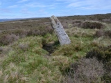
SandyG visited on 6th Jun 2016 - their rating: Cond: 2 Amb: 4 Access: 3 Visited without doing research first. I was looking for two stones. The upright stone is easy to spot but the recumbent one is a bit more difficult. I did find a recumbent stone that looked about right, but it was not the right one. I suppose it is possible that there were once more standing stones at this spot, but the proximity of the cliff means that at least some of the large slabs are probably natural.
tom_bullock have visited here
Average ratings for this site from all visit loggers: Condition: 3.5 Ambience: 4 Access: 2.5
")
Visited without doing research first. I was looking for two stones. The upright stone is easy to spot but the recumbent one is a bit more difficult. I did find a recumbent stone that looked about right, but it was not the right one. I suppose it is possible that there were once more standing stones at this spot, but the proximity of the cliff means that at least some of the large slabs are probably natural.
Page originally created by Vicky
You may be viewing yesterday's version of this page. To see the most up to date information please register for a free account.
")
")
")
")
")
")
")
")
")
")
Do not use the above information on other web sites or publications without permission of the contributor.
Click here to see more info for this site
Nearby sites
Key: Red: member's photo, Blue: 3rd party photo, Yellow: other image, Green: no photo - please go there and take one, Grey: site destroyed
Download sites to:
KML (Google Earth)
GPX (GPS waypoints)
CSV (Garmin/Navman)
CSV (Excel)
To unlock full downloads you need to sign up as a Contributory Member. Otherwise downloads are limited to 50 sites.
![]()
![]()
Turn off the page maps and other distractions
Nearby sites listing. In the following links * = Image available
1.5km ENE 57° Uisken.* Standing Stone (Menhir) (NM3919119632)
3.1km NNW 342° Suie* Standing Stones (NM37062185)
4.0km NNE 25° Taoslin* Standing Stone (Menhir) (NM3973122388)
4.3km NW 321° Tirghoil* Standing Stone (Menhir) (NM35322242)
6.2km WNW 298° Poit Na H-i Stone* Standing Stone (Menhir) (NM3251022174)
7.7km WNW 300° Loch Poit Na H-I* Crannog (NM31432313)
7.9km WNW 301° Achaban House* Standing Stone (Menhir) (NM31332331)
10.7km WNW 296° St Mary's Nunnery (Iona) Ancient Cross (NM2850424110)
10.7km WNW 300° Cladh an Diseirt* Cairn (NM28842475)
10.7km WNW 297° Clach Braith (Iona) Natural Stone / Erratic / Other Natural Feature (NM286244)
10.8km WNW 298° Iona Cross* Ancient Cross (NM286245)
11.4km WNW 300° Tobar nah Aois* Holy Well or Sacred Spring (NM283252)
12.1km WNW 298° Tobar na Gaoithe Tuath (Iona) Holy Well or Sacred Spring (NM275252)
12.4km NE 55° An Dun (Mull)* Stone Fort or Dun (NM484254)
12.7km WNW 293° Dun Cul Bhuirg (Iona)* Hillfort (NM26492462)
17.6km NNE 16° Inch Kenneth Stone Standing Stone (Menhir) (NM4385835492)
18.9km ENE 57° Rossal* Standing Stone (Menhir) (NM543282)
20.0km SSE 163° Cnoc A'Charragh Standing Stone (Menhir) (NR42669940)
20.1km NE 53° Uluvalt Standing Stones* Standing Stones (NM54633002)
20.1km NE 53° Uluvalt Standing Stone* Standing Stone (Menhir) (NM54692997)
20.3km N 3° Cragaig* Standing Stones (NM40283901)
20.6km NNE 32° Dishig* Standing Stone (Menhir) (NM49693574)
20.9km N 9° Ulva Standing Stone Standing Stone (Menhir) (NM42563926)
20.9km NNE 16° Meall Min Rock Art (NM447387)
21.2km N 354° Tigh An Duine Stone Fort or Dun (NM36944013)
View more nearby sites and additional images


 We would like to know more about this location. Please feel free to add a brief description and any relevant information in your own language.
 Wir möchten mehr über diese Stätte erfahren. Bitte zögern Sie nicht, eine kurze Beschreibung und relevante Informationen in Deutsch hinzuzufügen.
 Nous aimerions en savoir encore un peu sur les lieux. S'il vous plaît n'hesitez pas à ajouter une courte description et tous les renseignements pertinents dans votre propre langue.
 Quisieramos informarnos un poco más de las lugares. No dude en añadir una breve descripción y otros datos relevantes en su propio idioma.