 with our Megalithic Portal iPhone app")


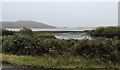
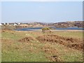
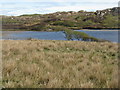
<< Our Photo Pages >> Loch Poit Na H-I - Crannog in Scotland in Isle of Mull
Submitted by cosmic on Monday, 08 June 2009 Page Views: 5529
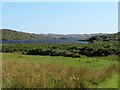
Iron Age and Later PrehistorySite Name: Loch Poit Na H-ICountry: Scotland County: Isle of Mull Type: Crannog
Map Ref: NM31432313
Latitude: 56.324178N Longitude: 6.345719W
Condition:
| 5 | Perfect |
| 4 | Almost Perfect |
| 3 | Reasonable but with some damage |
| 2 | Ruined but still recognisable as an ancient site |
| 1 | Pretty much destroyed, possibly visible as crop marks |
| 0 | No data. |
| -1 | Completely destroyed |
| 5 | Superb |
| 4 | Good |
| 3 | Ordinary |
| 2 | Not Good |
| 1 | Awful |
| 0 | No data. |
| 5 | Can be driven to, probably with disabled access |
| 4 | Short walk on a footpath |
| 3 | Requiring a bit more of a walk |
| 2 | A long walk |
| 1 | In the middle of nowhere, a nightmare to find |
| 0 | No data. |
| 5 | co-ordinates taken by GPS or official recorded co-ordinates |
| 4 | co-ordinates scaled from a detailed map |
| 3 | co-ordinates scaled from a bad map |
| 2 | co-ordinates of the nearest village |
| 1 | co-ordinates of the nearest town |
| 0 | no data |
Internal Links:
External Links:
I have visited· I would like to visit
Gongoozler has visited here
")
Only the one in bottom right of the picture is a crannog, the others are natural islands.
Canmore site no. 21769.
You may be viewing yesterday's version of this page. To see the most up to date information please register for a free account.
Do not use the above information on other web sites or publications without permission of the contributor.
coldrum has found this location on Google Street View:
Nearby Images from Geograph Britain and Ireland:
©2020(licence)
©2019(licence)
©2021(licence)
©2012(licence)
©2018(licence)
The above images may not be of the site on this page, they are loaded from Geograph.
Please Submit an Image of this site or go out and take one for us!
Click here to see more info for this site
Nearby sites
Key: Red: member's photo, Blue: 3rd party photo, Yellow: other image, Green: no photo - please go there and take one, Grey: site destroyed
Download sites to:
KML (Google Earth)
GPX (GPS waypoints)
CSV (Garmin/Navman)
CSV (Excel)
To unlock full downloads you need to sign up as a Contributory Member. Otherwise downloads are limited to 50 sites.
Turn off the page maps and other distractions
Nearby sites listing. In the following links * = Image available
205m NNW 327° Achaban House* Standing Stone (Menhir) (NM31332331)
1.4km SE 128° Poit Na H-I Stone* Standing Stone (Menhir) (NM3251022174)
3.0km WNW 298° Cladh an Diseirt* Cairn (NM28842475)
3.1km WNW 285° St Mary's Nunnery (Iona) Ancient Cross (NM2850424110)
3.1km WNW 291° Clach Braith (Iona) Natural Stone / Erratic / Other Natural Feature (NM286244)
3.1km WNW 292° Iona Cross* Ancient Cross (NM286245)
3.7km WNW 300° Tobar nah Aois* Holy Well or Sacred Spring (NM283252)
3.9km E 97° Tirghoil* Standing Stone (Menhir) (NM35322242)
4.4km WNW 294° Tobar na Gaoithe Tuath (Iona) Holy Well or Sacred Spring (NM275252)
5.1km WNW 283° Dun Cul Bhuirg (Iona) Hillfort (NM26492462)
5.8km E 99° Suie* Standing Stones (NM37062185)
7.7km ESE 120° Ardalanish* Standing Stones (NM37841887)
8.3km E 91° Taoslin* Standing Stone (Menhir) (NM3973122388)
8.5km ESE 111° Uisken.* Standing Stone (Menhir) (NM3919119632)
17.1km ENE 79° An Dun (Mull)* Stone Fort or Dun (NM484254)
17.5km NE 41° Inch Kenneth Stone Standing Stone (Menhir) (NM4385835492)
17.8km NNE 14° Tigh An Duine Stone Fort or Dun (NM36944013)
18.1km NNE 25° Cragaig* Standing Stones (NM40283901)
19.3km NNW 345° Dun Cruit Stone Fort or Dun (NM27634206)
19.6km NNE 31° Ulva Standing Stone Standing Stone (Menhir) (NM42563926)
20.4km NE 37° Meall Min Rock Art (NM447387)
22.1km NE 52° Dishig* Standing Stone (Menhir) (NM49693574)
22.9km NNE 12° Dun Aisgain Stone Fort or Dun (NM37744524)
23.2km NNE 15° Dun Ban, Tostarie Stone Fort or Dun (NM38694524)
23.3km ENE 74° Rossal* Standing Stone (Menhir) (NM543282)
View more nearby sites and additional images


 We would like to know more about this location. Please feel free to add a brief description and any relevant information in your own language.
 Wir möchten mehr über diese Stätte erfahren. Bitte zögern Sie nicht, eine kurze Beschreibung und relevante Informationen in Deutsch hinzuzufügen.
 Nous aimerions en savoir encore un peu sur les lieux. S'il vous plaît n'hesitez pas à ajouter une courte description et tous les renseignements pertinents dans votre propre langue.
 Quisieramos informarnos un poco más de las lugares. No dude en añadir una breve descripción y otros datos relevantes en su propio idioma.