 with our Megalithic Portal iPhone app")

<< Our Photo Pages >> Mayon Cliff cairn - Cairn in England in Cornwall
Submitted by JimChampion on Sunday, 31 August 2008 Page Views: 7346
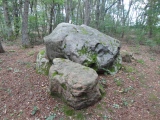
Neolithic and Bronze AgeSite Name: Mayon Cliff cairnCountry: England County: Cornwall Type: Cairn
Nearest Town: Penzance Nearest Village: Sennen Cove
Map Ref: SW34812602
Latitude: 50.075005N Longitude: 5.707763W
Condition:
| 5 | Perfect |
| 4 | Almost Perfect |
| 3 | Reasonable but with some damage |
| 2 | Ruined but still recognisable as an ancient site |
| 1 | Pretty much destroyed, possibly visible as crop marks |
| 0 | No data. |
| -1 | Completely destroyed |
| 5 | Superb |
| 4 | Good |
| 3 | Ordinary |
| 2 | Not Good |
| 1 | Awful |
| 0 | No data. |
| 5 | Can be driven to, probably with disabled access |
| 4 | Short walk on a footpath |
| 3 | Requiring a bit more of a walk |
| 2 | A long walk |
| 1 | In the middle of nowhere, a nightmare to find |
| 0 | No data. |
| 5 | co-ordinates taken by GPS or official recorded co-ordinates |
| 4 | co-ordinates scaled from a detailed map |
| 3 | co-ordinates scaled from a bad map |
| 2 | co-ordinates of the nearest village |
| 1 | co-ordinates of the nearest town |
| 0 | no data |
Internal Links:
External Links:
I have visited· I would like to visit
TheCaptain visited on 14th Jun 2022 - their rating: Cond: 3 Amb: 5 Access: 4 From Sennen Cove, I decide to walk up to the coastguard lookout shelter and on to look at the shipwreck of the RMS Mülheim, wrecked March 2003, the path passing right beside the Mayon Cliff cairn, and with the cliff castle clearly visible the other side.
rosecapybara515 visited on 21st Jun 2019 - their rating: Cond: 2 Amb: 4 Access: 4
lucasn visited - their rating: Cond: 4 Amb: 5 Access: 3
Bladup JimChampion have visited here
Average ratings for this site from all visit loggers: Condition: 3 Ambience: 4.67 Access: 3.67
")
You may be viewing yesterday's version of this page. To see the most up to date information please register for a free account.
")
")
")
")
")
")
")
")
")
")
")
")
")
")
")
")
")
")
")
")
")
")
")
")
")
These are just the first 25 photos of Mayon Cliff cairn. If you log in with a free user account you will be able to see our entire collection.
Do not use the above information on other web sites or publications without permission of the contributor.
Click here to see more info for this site
Nearby sites
Key: Red: member's photo, Blue: 3rd party photo, Yellow: other image, Green: no photo - please go there and take one, Grey: site destroyed
Download sites to:
KML (Google Earth)
GPX (GPS waypoints)
CSV (Garmin/Navman)
CSV (Excel)
To unlock full downloads you need to sign up as a Contributory Member. Otherwise downloads are limited to 50 sites.
Turn off the page maps and other distractions
Nearby sites listing. In the following links * = Image available
190m E 93° Whitesand Bay Stone Circle (SW350260)
265m S 188° Maen Castle* Promontory Fort / Cliff Castle (SW34762576)
805m ESE 119° Sennen Hedge* Standing Stone (Menhir) (SW355256)
964m SSW 209° Land’s End Iron Age Settlement* Hillfort (SW343252)
975m E 91° Mayon menhir* Standing Stone (Menhir) (SW3578625948)
1.0km ESE 118° Sennen Church* Ancient Cross (SW357255)
1.1km E 99° Table Maen* Natural Stone / Erratic / Other Natural Feature (SW359258)
1.2km SE 133° Trevescan Cross* Early Christian Sculptured Stone (SW3563425178)
1.3km ESE 103° Mayon Farm Cross* Early Christian Sculptured Stone (SW3607625653)
1.5km ENE 61° Carn Towan Cross* Ancient Cross (SW3612626668)
1.6km SE 144° Trevilley Cross* Early Christian Sculptured Stone (SW3569524648)
1.7km ESE 103° Brew Cross Ancient Cross (SW36462556)
1.7km S 181° Pordenack Point* Promontory Fort / Cliff Castle (SW347243)
1.8km NE 47° Escalls Cliff Cairn* Cairn (SW362272)
1.9km S 181° Trevilley Cliff Tumuli* Barrow Cemetery (SW34682417)
1.9km S 173° Mushroom Rock* Rock Outcrop (SW34952415)
2.1km E 88° Trevear Sennen* Standing Stone (Menhir) (SW369260)
2.5km SSE 156° Lower Bosistow Cliff Cave Cave or Rock Shelter (SW357237)
2.9km SSE 157° Higher Bosistow Cliff Tumulus* Round Barrow(s) (SW35792330)
2.9km NE 56° Trevedra Common Tumuli Barrow Cemetery (SW37292752)
2.9km SSE 161° Carn Lês Boel* Promontory Fort / Cliff Castle (SW35642323)
3.0km NE 52° Tregiffian Vean* Chambered Tomb (SW37252773)
3.1km SE 144° Higher Bosistow Menhir* Standing Stone (Menhir) (SW36532338)
3.2km NNE 22° Nanjulian courtyard house settlement* Ancient Village or Settlement (SW36152888)
3.3km ESE 118° Trebehor Cross* Early Christian Sculptured Stone (SW3763824319)
View more nearby sites and additional images


 We would like to know more about this location. Please feel free to add a brief description and any relevant information in your own language.
 Wir möchten mehr über diese Stätte erfahren. Bitte zögern Sie nicht, eine kurze Beschreibung und relevante Informationen in Deutsch hinzuzufügen.
 Nous aimerions en savoir encore un peu sur les lieux. S'il vous plaît n'hesitez pas à ajouter une courte description et tous les renseignements pertinents dans votre propre langue.
 Quisieramos informarnos un poco más de las lugares. No dude en añadir una breve descripción y otros datos relevantes en su propio idioma.