<< Text Pages >> Carn Ysgubor - Cairn in Wales in Pembrokeshire
Submitted by coin on Tuesday, 10 July 2018 Page Views: 1569
Neolithic and Bronze AgeSite Name: Carn YsguborCountry: Wales County: Pembrokeshire Type: Cairn
Map Ref: SM69992460
Latitude: 51.872419N Longitude: 5.342715W
Condition:
| 5 | Perfect |
| 4 | Almost Perfect |
| 3 | Reasonable but with some damage |
| 2 | Ruined but still recognisable as an ancient site |
| 1 | Pretty much destroyed, possibly visible as crop marks |
| 0 | No data. |
| -1 | Completely destroyed |
| 5 | Superb |
| 4 | Good |
| 3 | Ordinary |
| 2 | Not Good |
| 1 | Awful |
| 0 | No data. |
| 5 | Can be driven to, probably with disabled access |
| 4 | Short walk on a footpath |
| 3 | Requiring a bit more of a walk |
| 2 | A long walk |
| 1 | In the middle of nowhere, a nightmare to find |
| 0 | No data. |
| 5 | co-ordinates taken by GPS or official recorded co-ordinates |
| 4 | co-ordinates scaled from a detailed map |
| 3 | co-ordinates scaled from a bad map |
| 2 | co-ordinates of the nearest village |
| 1 | co-ordinates of the nearest town |
| 0 | no data |
Internal Links:
External Links:
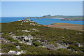
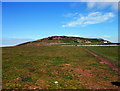
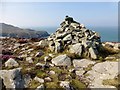
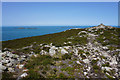
Cairn in Pembrokeshire
Originally a round barrow (DAT record), now restructured using the stone from the cairn to form two concentric walls forming a double feature, possibly used as a beacon or possibly a lighthouse (DAT record).
You may be viewing yesterday's version of this page. To see the most up to date information please register for a free account.
Do not use the above information on other web sites or publications without permission of the contributor.
Nearby Images from Geograph Britain and Ireland:
©2015(licence)
©2014(licence)
©2014(licence)
©2015(licence)
©2015(licence)
The above images may not be of the site on this page, they are loaded from Geograph.
Please Submit an Image of this site or go out and take one for us!
Click here to see more info for this site
Nearby sites
Key: Red: member's photo, Blue: 3rd party photo, Yellow: other image, Green: no photo - please go there and take one, Grey: site destroyed
Download sites to:
KML (Google Earth)
GPX (GPS waypoints)
CSV (Garmin/Navman)
CSV (Excel)
To unlock full downloads you need to sign up as a Contributory Member. Otherwise downloads are limited to 50 sites.
Turn off the page maps and other distractions
Nearby sites listing. In the following links * = Image available
445m SE 133° Ramsay Monolith* Modern Stone Circle etc (SM70302428)
1.3km SSW 192° Carn Llundain (South)* Cairn (SM69652331)
2.1km ESE 116° Lower Treginnis Cairn (SM718236)
2.4km E 85° Castell Henif* Promontory Fort / Cliff Castle (SM72362469)
2.5km ENE 73° St Justinian's Well* Holy Well or Sacred Spring (SM72402522)
2.5km ENE 69° St Justinians North* Standing Stone (Menhir) (SM7237625371)
2.6km ENE 72° St Justinians East* Standing Stone (Menhir) (SM7252725278)
3.0km ENE 75° Rhosson Well Holy Well or Sacred Spring (SM72932526)
3.4km ENE 65° Trelyddan Well Holy Well or Sacred Spring (SM731259)
3.6km E 81° Ffynnon Llygaid (Great Orme) Holy Well or Sacred Spring (SM736250)
3.8km E 80° Clegyr Boia* Hillfort (SM73732509)
3.9km E 93° Porth Clais well* Holy Well or Sacred Spring (SM739242)
4.0km NNE 32° St David's Head* Hillfort (SM723279)
4.1km NE 49° Whitesands Bay Submerged Forest Not Known (by us) (SM7320227125)
4.3km NNE 34° Coetan Arthur Dolmen* Chambered Tomb (SM72532806)
4.6km NE 53° Ffynnon Faiddog Holy Well or Sacred Spring (SM73842720)
4.7km NE 37° St.David's Head* Stone Row / Alignment (SM72952822)
4.8km NE 44° Carn Llidi* Chambered Tomb (SM73512790)
5.1km E 90° St Non's Chapel* Early Christian Sculptured Stone (SM7507524345)
5.1km E 90° St Non's Well (Pembrokeshire)* Holy Well or Sacred Spring (SM75102437)
5.2km E 79° St David's Cathedral* Ancient Cross (SM75202536)
5.4km ENE 78° Ffynnon-Y-Cwcwll Holy Well or Sacred Spring (SM7533725498)
5.6km ENE 69° Trefarchan* Standing Stone (Menhir) (SM7531126407)
5.6km E 81° Cocyn Round* Misc. Earthwork (SM7559325258)
5.6km E 81° Pembrokeshire National Park Visitors Centre* Museum (SM756252)
View more nearby sites and additional images


 We would like to know more about this location. Please feel free to add a brief description and any relevant information in your own language.
 Wir möchten mehr über diese Stätte erfahren. Bitte zögern Sie nicht, eine kurze Beschreibung und relevante Informationen in Deutsch hinzuzufügen.
 Nous aimerions en savoir encore un peu sur les lieux. S'il vous plaît n'hesitez pas à ajouter une courte description et tous les renseignements pertinents dans votre propre langue.
 Quisieramos informarnos un poco más de las lugares. No dude en añadir una breve descripción y otros datos relevantes en su propio idioma.