<< Text Pages >> Dun Rodil - Broch or Nuraghe in Scotland in Isle of Harris
Submitted by SolarMegalith on Tuesday, 29 November 2011 Page Views: 2890
Iron Age and Later PrehistorySite Name: Dun RodilCountry: Scotland
NOTE: This site is 0.5 km away from the location you searched for.
County: Isle of Harris Type: Broch or Nuraghe
Map Ref: NG05018330
Latitude: 57.742131N Longitude: 6.959209W
Condition:
| 5 | Perfect |
| 4 | Almost Perfect |
| 3 | Reasonable but with some damage |
| 2 | Ruined but still recognisable as an ancient site |
| 1 | Pretty much destroyed, possibly visible as crop marks |
| 0 | No data. |
| -1 | Completely destroyed |
| 5 | Superb |
| 4 | Good |
| 3 | Ordinary |
| 2 | Not Good |
| 1 | Awful |
| 0 | No data. |
| 5 | Can be driven to, probably with disabled access |
| 4 | Short walk on a footpath |
| 3 | Requiring a bit more of a walk |
| 2 | A long walk |
| 1 | In the middle of nowhere, a nightmare to find |
| 0 | No data. |
| 5 | co-ordinates taken by GPS or official recorded co-ordinates |
| 4 | co-ordinates scaled from a detailed map |
| 3 | co-ordinates scaled from a bad map |
| 2 | co-ordinates of the nearest village |
| 1 | co-ordinates of the nearest town |
| 0 | no data |
Internal Links:
External Links:
I have visited· I would like to visit
Megalithicmatt visited on 13th Sep 2015 - their rating: Cond: 2 Amb: 3 Access: 3 Walked up from the curve in the road, the way was quite boggy. Didn't stay more than five minutes as it was very rainy and windy, so bad that there was a threat of being blown off the top!
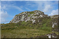
Hard to discern much in the way of structure in the ruins, though there did appear to be a small semi-circular arrangement of stones nearby to the main ruin pile on the top of the hillock.
Remains of a broch of 13,7 m diameter, previously indentified as a dun. The internal diameter of the tower is 6,1 m.
MacKie E. The Roundhouses, Brochs and Wheelhouses of Atlantic Scotland c. 700 BC - AD 500. Part 2: II. Oxford: BAR.
You may be viewing yesterday's version of this page. To see the most up to date information please register for a free account.
Do not use the above information on other web sites or publications without permission of the contributor.
Nearby Images from Geograph Britain and Ireland:
©2011(licence)
©2008(licence)
©2013(licence)
©2009(licence)
©2012(licence)
The above images may not be of the site on this page, they are loaded from Geograph.
Please Submit an Image of this site or go out and take one for us!
Click here to see more info for this site
Nearby sites
Key: Red: member's photo, Blue: 3rd party photo, Yellow: other image, Green: no photo - please go there and take one, Grey: site destroyed
Download sites to:
KML (Google Earth)
GPX (GPS waypoints)
CSV (Garmin/Navman)
CSV (Excel)
To unlock full downloads you need to sign up as a Contributory Member. Otherwise downloads are limited to 50 sites.
Turn off the page maps and other distractions
Nearby sites listing. In the following links * = Image available
546m WSW 244° Roghadal (Rodel) Stone Circle (NG045831)
3.6km WNW 298° Dun Innisgall Stone Fort or Dun (NG01948521)
6.9km NW 305° Rubha Charnain* Rock Art (NF996877)
7.7km WNW 292° Taigh Easaigh Standing Stone Standing Stone (Menhir) (NF9804186677)
7.7km WNW 293° Ensay Rock Art (NF981868)
10.8km NNW 347° Dun Borve (nr Scarista)* Broch or Nuraghe (NG034940)
10.9km NNW 341° S46 Scarista* Stone Row / Alignment (NG0217793898)
11.0km NNW 340° Borvemore* Stone Row / Alignment (NG02029392)
11.3km NW 311° Rubh' an Teampuill, Toe Head* Broch or Nuraghe (NF97019133)
11.3km NW 311° Harris, Rubh' An Teampuill* Rock Art (NF96969129)
12.4km SSW 211° Dun Mhic Laitheann Stone Fort or Dun (NF9778873187)
12.6km W 263° Bhruist Stone Circle* Stone Circle (NF92418279)
12.7km W 259° Cnoc na Greana* Stone Row / Alignment (NF9230781876)
13.3km N 355° Coire Na Feinne* Chambered Cairn (NG0471896628)
13.9km N 352° Clach Mhic Leoid* Standing Stone (Menhir) (NG04109718)
14.0km WSW 255° Cladh Maolrithe* Standing Stone (Menhir) (NF91218068)
14.3km WSW 259° Sgalabraig* Souterrain (Fogou, Earth House) (NF90718153)
16.2km WSW 243° Beinn A Chaolais Stone Circle (NF900770)
16.3km WSW 245° Dun an Sticir* Broch or Nuraghe (NF897776)
16.4km WSW 248° Crois Mhic Jamain* Stone Row / Alignment (NF89397820)
16.5km WSW 249° Port nan Long Souterrain (Fogou, Earth House) (NF892784)
17.2km WSW 245° Baile Mhic' Phàil Stone Setting* Cairn (NF88937711)
17.8km NNW 344° Clach An Teampuill (Taransay)* Standing Stone (Menhir) (NB01280077)
18.6km WSW 243° Dun Rosail Stone Fort or Dun (NF87837595)
18.7km SW 235° Dun Torcuill Stone Fort or Dun (NF8888573730)
View more nearby sites and additional images


 We would like to know more about this location. Please feel free to add a brief description and any relevant information in your own language.
 Wir möchten mehr über diese Stätte erfahren. Bitte zögern Sie nicht, eine kurze Beschreibung und relevante Informationen in Deutsch hinzuzufügen.
 Nous aimerions en savoir encore un peu sur les lieux. S'il vous plaît n'hesitez pas à ajouter une courte description et tous les renseignements pertinents dans votre propre langue.
 Quisieramos informarnos un poco más de las lugares. No dude en añadir una breve descripción y otros datos relevantes en su propio idioma.