

<< Our Photo Pages >> Søndenbro Langdysse - Long Barrow in Denmark in Fyn, Langeland and Islands
Submitted by praeceptor on Saturday, 19 June 2010 Page Views: 1704
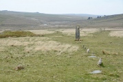
Neolithic and Bronze AgeSite Name: Søndenbro Langdysse Alternative Name: MaderneCountry: Denmark County: Fyn, Langeland and Islands Type: Long Barrow
Nearest Town: Svendborg Nearest Village: Magleby
Latitude: 54.763595N Longitude: 10.693949E
Condition:
| 5 | Perfect |
| 4 | Almost Perfect |
| 3 | Reasonable but with some damage |
| 2 | Ruined but still recognisable as an ancient site |
| 1 | Pretty much destroyed, possibly visible as crop marks |
| 0 | No data. |
| -1 | Completely destroyed |
| 5 | Superb |
| 4 | Good |
| 3 | Ordinary |
| 2 | Not Good |
| 1 | Awful |
| 0 | No data. |
| 5 | Can be driven to, probably with disabled access |
| 4 | Short walk on a footpath |
| 3 | Requiring a bit more of a walk |
| 2 | A long walk |
| 1 | In the middle of nowhere, a nightmare to find |
| 0 | No data. |
| 5 | co-ordinates taken by GPS or official recorded co-ordinates |
| 4 | co-ordinates scaled from a detailed map |
| 3 | co-ordinates scaled from a bad map |
| 2 | co-ordinates of the nearest village |
| 1 | co-ordinates of the nearest town |
| 0 | no data |
Be the first person to rate this site - see the 'Contribute!' box in the right hand menu.
Internal Links:
External Links:
I have visited· I would like to visit
praeceptor visited on 1st Jan 2011 - their rating: Cond: 2 Amb: 2 Access: 2 In dire need for a total renovation
praeceptor visited on 1st Jan 2011 - their rating: Cond: 2 Amb: 2 Access: 2 In dire need for a total renovation
Average ratings for this site from all visit loggers: Condition: 2 Ambience: 2 Access: 2
")
More information at www.kulturarv.dk: Danish Sites and Monuments Record: 090306-58
"Fortidsmindedata Copyright Kulturarvsstyrelsen"
You may be viewing yesterday's version of this page. To see the most up to date information please register for a free account.
")
")
")
")
")
")
")
")
")
")
Do not use the above information on other web sites or publications without permission of the contributor.
Click here to see more info for this site
Nearby sites
Click here to view sites on an interactive map of the areaKey: Red: member's photo, Blue: 3rd party photo, Yellow: other image, Green: no photo - please go there and take one, Grey: site destroyed
Download sites to:
KML (Google Earth)
GPX (GPS waypoints)
CSV (Garmin/Navman)
CSV (Excel)
To unlock full downloads you need to sign up as a Contributory Member. Otherwise downloads are limited to 50 sites.
Turn off the page maps and other distractions
Nearby sites listing. In the following links * = Image available
829m SE 132° Lindebjerggård Dysse (modern)* Modern Stone Circle etc
991m W 275° Magleby Nor Langdysse 1* Long Barrow
1.1km WNW 297° Magleby Nor Runddysse* Burial Chamber or Dolmen
1.3km NW 325° Magleby Nor Langdysse 2* Long Barrow
1.3km W 266° Magleby Nor Langdysse 3* Long Barrow
1.7km WNW 294° Bagenkop Vestervej Rundhøj* Round Barrow(s)
1.8km NNE 16° Nordenbro Langdysse* Long Barrow
2.0km NNW 337° Vesteregn (modern)* Modern Stone Circle etc
3.0km NW 321° Reddemandstenen* Marker Stone
3.1km NNW 344° Ormstrup Langdysse* Long Barrow
3.1km S 188° Hulbjerg Jættestue* Passage Grave
3.3km N 353° Ormstrup Runddysse* Burial Chamber or Dolmen
3.4km ENE 63° Bøsseløkke Jættestue* Passage Grave
3.8km SSE 148° Lunden Runddysse* Burial Chamber or Dolmen
3.8km NW 326° Ormstrup Jættestue* Burial Chamber or Dolmen
3.9km N 349° Kinderballe Jættestue 2* Passage Grave
3.9km N 354° Kinderballe Jættestue 1* Passage Grave
4.1km S 190° Gulstav Runddysse 2* Burial Chamber or Dolmen
4.3km S 188° Gulstav Runddysse 1* Burial Chamber or Dolmen
4.4km S 179° Østre Gulstav Langhøj* Long Barrow
5.3km NNE 26° Tolsbjerg Skov Jættestue 2* Passage Grave
5.5km NNE 25° Tolsbjerg Skov Jættestue 1* Passage Grave
5.8km N 352° Hesselbjerg Langdysse* Long Barrow
5.9km NNW 338° Hesselbjerg Megalitgrav* Burial Chamber or Dolmen
6.0km NNW 341° Hesselbjerg Jættestue* Passage Grave
View more nearby sites and additional images


 We would like to know more about this location. Please feel free to add a brief description and any relevant information in your own language.
 Wir möchten mehr über diese Stätte erfahren. Bitte zögern Sie nicht, eine kurze Beschreibung und relevante Informationen in Deutsch hinzuzufügen.
 Nous aimerions en savoir encore un peu sur les lieux. S'il vous plaît n'hesitez pas à ajouter une courte description et tous les renseignements pertinents dans votre propre langue.
 Quisieramos informarnos un poco más de las lugares. No dude en añadir una breve descripción y otros datos relevantes en su propio idioma.