
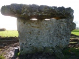

<< Our Photo Pages >> Dolmen du Creux - Burial Chamber or Dolmen in France in Normandie:Orne (61)
Submitted by t4t35 on Saturday, 16 April 2005 Page Views: 4704
Neolithic and Bronze AgeSite Name: Dolmen du Creux Alternative Name: Dolmen de Saint-Bômer-Les-ForgesCountry: France Département: Normandie:Orne (61) Type: Burial Chamber or Dolmen
Nearest Town: Flers Nearest Village: Saint-Bômer-les-Forges
Latitude: 48.644787N Longitude: 0.604335W
Condition:
| 5 | Perfect |
| 4 | Almost Perfect |
| 3 | Reasonable but with some damage |
| 2 | Ruined but still recognisable as an ancient site |
| 1 | Pretty much destroyed, possibly visible as crop marks |
| 0 | No data. |
| -1 | Completely destroyed |
| 5 | Superb |
| 4 | Good |
| 3 | Ordinary |
| 2 | Not Good |
| 1 | Awful |
| 0 | No data. |
| 5 | Can be driven to, probably with disabled access |
| 4 | Short walk on a footpath |
| 3 | Requiring a bit more of a walk |
| 2 | A long walk |
| 1 | In the middle of nowhere, a nightmare to find |
| 0 | No data. |
| 5 | co-ordinates taken by GPS or official recorded co-ordinates |
| 4 | co-ordinates scaled from a detailed map |
| 3 | co-ordinates scaled from a bad map |
| 2 | co-ordinates of the nearest village |
| 1 | co-ordinates of the nearest town |
| 0 | no data |
Internal Links:
External Links:
I have visited· I would like to visit
thereddragon visited on 18th Oct 2012 - their rating: Cond: 4 Amb: 5 Access: 4 What a lovely little dolmen. And a cist to boot.
")
From thereddragon.
"East of Les Forges on the D56, take turning for L'Ourière-le-Creux. Carry straight on and when the road bends to the right, there should be a track straight ahead. You're not allowed to drive down the track so you have to park near this junction. The ensemble is signposted by a small wooden sign. Lovely setting!
Thanks to Anne at the Domfront tourist office who explained the exact location of this site. She speaks excellent English and knows the area very well. And has gained access for the public to a number of neolithic sites in the area. Brilliant job!"
More at DLS1
You may be viewing yesterday's version of this page. To see the most up to date information please register for a free account.
")
")
")
Do not use the above information on other web sites or publications without permission of the contributor.
Nearby Images from Flickr

The above images may not be of the site on this page, but were taken nearby. They are loaded from Flickr so please click on them for image credits.
Click here to see more info for this site
Nearby sites
Click here to view sites on an interactive map of the areaKey: Red: member's photo, Blue: 3rd party photo, Yellow: other image, Green: no photo - please go there and take one, Grey: site destroyed
Download sites to:
KML (Google Earth)
GPX (GPS waypoints)
CSV (Garmin/Navman)
CSV (Excel)
To unlock full downloads you need to sign up as a Contributory Member. Otherwise downloads are limited to 50 sites.
Turn off the page maps and other distractions
Nearby sites listing. In the following links * = Image available
786m S 188° Dolmen du Bois de la Maigraire Burial Chamber or Dolmen
2.5km WSW 238° La Ciste du Pi de Chien* Cist
2.9km WNW 285° La Bésrardière tumulus Chambered Tomb
4.9km NE 34° Le Châtellier megalithic bridge* Ancient Trackway
5.6km NNE 13° Chambre à la Dame Burial Chamber or Dolmen
5.7km NNW 339° Lépinardière Dolmen* Burial Chamber or Dolmen
12.5km E 100° La Bertinière* Passage Grave
13.6km SE 130° Dolmen dit le Lit de la Gione* Burial Chamber or Dolmen
14.9km NE 36° Landigou Menhir Standing Stone (Menhir)
15.8km WSW 238° La Pierre-Saint-Martin Polissoir
15.8km NE 38° Menhir de la Croix Carrée (Landigou)* Standing Stone (Menhir)
19.2km SW 219° La Table aux Diables (Passais)* Passage Grave
20.1km S 191° Menhir dit la Grande Pierre (Ceaucé) Standing Stone (Menhir)
20.8km SW 215° Perron Menhir* Standing Stone (Menhir)
20.8km NE 48° Dolmen du Bois de la Mousse Burial Chamber or Dolmen
21.5km SSW 213° Menhir du Chêne aux Fées Standing Stone (Menhir)
21.8km NE 55° L'Affiloire de Gargantua* Standing Stone (Menhir)
22.5km SSW 201° Menhir de Moncorbeau* Standing Stone (Menhir)
22.7km W 269° Rocher du Dolmen (Mortain)* Natural Stone / Erratic / Other Natural Feature
22.8km NE 51° Menhir dit la Droite Pierre (Chênedouit)* Standing Stone (Menhir)
22.9km S 171° Bignon Menhir* Standing Stone (Menhir)
23.0km S 171° Bignon Dolmen* Burial Chamber or Dolmen
23.0km S 173° Dolmen de la Guichardière Burial Chamber or Dolmen
23.1km W 277° Le Dolmen de Roche-Grise Burial Chamber or Dolmen
23.4km ENE 58° Dolmen de la Cardotière Burial Chamber or Dolmen
View more nearby sites and additional images


 We would like to know more about this location. Please feel free to add a brief description and any relevant information in your own language.
 Wir möchten mehr über diese Stätte erfahren. Bitte zögern Sie nicht, eine kurze Beschreibung und relevante Informationen in Deutsch hinzuzufügen.
 Nous aimerions en savoir encore un peu sur les lieux. S'il vous plaît n'hesitez pas à ajouter une courte description et tous les renseignements pertinents dans votre propre langue.
 Quisieramos informarnos un poco más de las lugares. No dude en añadir una breve descripción y otros datos relevantes en su propio idioma.