


<< Our Photo Pages >> Perron Menhir - Standing Stone (Menhir) in France in Normandie:Orne (61)
Submitted by TheCaptain on Saturday, 16 April 2005 Page Views: 4236
Neolithic and Bronze AgeSite Name: Perron Menhir Alternative Name: Menhir du PerronCountry: France Département: Normandie:Orne (61) Type: Standing Stone (Menhir)
Nearest Town: Domfront Nearest Village: Passais
Latitude: 48.492100N Longitude: 0.7667W
Condition:
| 5 | Perfect |
| 4 | Almost Perfect |
| 3 | Reasonable but with some damage |
| 2 | Ruined but still recognisable as an ancient site |
| 1 | Pretty much destroyed, possibly visible as crop marks |
| 0 | No data. |
| -1 | Completely destroyed |
| 5 | Superb |
| 4 | Good |
| 3 | Ordinary |
| 2 | Not Good |
| 1 | Awful |
| 0 | No data. |
| 5 | Can be driven to, probably with disabled access |
| 4 | Short walk on a footpath |
| 3 | Requiring a bit more of a walk |
| 2 | A long walk |
| 1 | In the middle of nowhere, a nightmare to find |
| 0 | No data. |
| 5 | co-ordinates taken by GPS or official recorded co-ordinates |
| 4 | co-ordinates scaled from a detailed map |
| 3 | co-ordinates scaled from a bad map |
| 2 | co-ordinates of the nearest village |
| 1 | co-ordinates of the nearest town |
| 0 | no data |
Internal Links:
External Links:
I have visited· I would like to visit
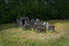
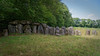
TheCaptain visited on 24th Apr 2005 - their rating: Cond: 3 Amb: 3 Access: 5 At least 3 metres high this menhir is found signposted about 30 metres from the road in a private garden although access to the stone is allowed up a driveway. There are at least two other large stones laying nearby and I wondered if one of these pieces was broken from the top of the menhir but the owner of the was in the garden and assured me that these had been put there as a garden feature by the previous owner.
thereddragon have visited here
")
At least 3 metres high, this menhir is found signposted about 30 metres from the road in a private garden, although access to the stone is allowed up a driveway.
There are at least two other large stones laying nearby, and I wondered if one of these pieces was broken from the top of the menhir, but the owner of the was in the garden and assured me that these had been put there as a garden feature by the previous owner.
IMPORTANT NOTE: Position of site taken from gps reciever.
More at MHD2
You may be viewing yesterday's version of this page. To see the most up to date information please register for a free account.
")
")
")
Do not use the above information on other web sites or publications without permission of the contributor.
Nearby Images from Flickr


The above images may not be of the site on this page, but were taken nearby. They are loaded from Flickr so please click on them for image credits.
Click here to see more info for this site
Nearby sites
Click here to view sites on an interactive map of the areaKey: Red: member's photo, Blue: 3rd party photo, Yellow: other image, Green: no photo - please go there and take one, Grey: site destroyed
Download sites to:
KML (Google Earth)
GPX (GPS waypoints)
CSV (Garmin/Navman)
CSV (Excel)
To unlock full downloads you need to sign up as a Contributory Member. Otherwise downloads are limited to 50 sites.
Turn off the page maps and other distractions
Nearby sites listing. In the following links * = Image available
1.2km SSE 161° Menhir du Chêne aux Fées Standing Stone (Menhir)
2.1km N 353° La Table aux Diables (Passais)* Passage Grave
5.5km SE 136° Menhir de Moncorbeau* Standing Stone (Menhir)
5.6km SSE 166° Chataigneraie Menhir* Standing Stone (Menhir)
7.9km WSW 250° Désertines Menhir* Standing Stone (Menhir)
8.4km S 179° La Pierre Saint-Guillaume Standing Stone (Menhir)
8.7km ESE 108° Menhir dit la Grande Pierre (Ceaucé) Standing Stone (Menhir)
8.8km N 350° La Pierre-Saint-Martin Polissoir
9.8km SSW 196° Menhir de la Roche (Gorron)* Standing Stone (Menhir)
10.1km SSE 155° Menhir dit la Pierre Saint-Siviard* Standing Stone (Menhir)
10.9km SW 218° Dolmen de la Pierre (Hercé)* Burial Chamber or Dolmen
12.8km SSW 196° Stèle de Brécé A Standing Stone (Menhir)
12.8km SSW 196° Stèle de Brécé B Standing Stone (Menhir)
13.4km S 176° Petit-Vieux-Sou* Passage Grave
14.4km S 172° l’Allée couverte de la Gasnerie Passage Grave
14.5km S 176° Menhir de la Chaire* Standing Stone (Menhir)
14.7km S 176° Allée couverte du Rocher Passage Grave
15.2km ESE 118° Grand Coudray Menhir* Standing Stone (Menhir)
15.9km S 174° Allée Couverte de la Grande-Burlaie Passage Grave
16.0km ESE 111° Dolmen de la Guichardière Burial Chamber or Dolmen
16.4km ESE 110° Bignon Menhir* Standing Stone (Menhir)
16.5km ESE 110° Bignon Dolmen* Burial Chamber or Dolmen
17.0km WSW 243° La Hutte-aux-Gabelous* Passage Grave
17.4km SSE 163° Menhir de la Chablère* Standing Stone (Menhir)
17.5km ESE 119° La Hamelinière* Passage Grave
View more nearby sites and additional images


 We would like to know more about this location. Please feel free to add a brief description and any relevant information in your own language.
 Wir möchten mehr über diese Stätte erfahren. Bitte zögern Sie nicht, eine kurze Beschreibung und relevante Informationen in Deutsch hinzuzufügen.
 Nous aimerions en savoir encore un peu sur les lieux. S'il vous plaît n'hesitez pas à ajouter une courte description et tous les renseignements pertinents dans votre propre langue.
 Quisieramos informarnos un poco más de las lugares. No dude en añadir una breve descripción y otros datos relevantes en su propio idioma.