<< Our Photo Pages >> Moneygashel - Stone Fort or Dun in Ireland (Republic of) in Co. Cavan
Submitted by Anthony_Weir on Monday, 14 October 2002 Page Views: 8864
Multi-periodSite Name: MoneygashelCountry: Ireland (Republic of) County: Co. Cavan Type: Stone Fort or Dun
Nearest Town: Dowra Nearest Village: Blacklion
Map Ref: H0594933908
Discovery Map Number: D26
Latitude: 54.254022N Longitude: 7.909472W
Condition:
| 5 | Perfect |
| 4 | Almost Perfect |
| 3 | Reasonable but with some damage |
| 2 | Ruined but still recognisable as an ancient site |
| 1 | Pretty much destroyed, possibly visible as crop marks |
| 0 | No data. |
| -1 | Completely destroyed |
| 5 | Superb |
| 4 | Good |
| 3 | Ordinary |
| 2 | Not Good |
| 1 | Awful |
| 0 | No data. |
| 5 | Can be driven to, probably with disabled access |
| 4 | Short walk on a footpath |
| 3 | Requiring a bit more of a walk |
| 2 | A long walk |
| 1 | In the middle of nowhere, a nightmare to find |
| 0 | No data. |
| 5 | co-ordinates taken by GPS or official recorded co-ordinates |
| 4 | co-ordinates scaled from a detailed map |
| 3 | co-ordinates scaled from a bad map |
| 2 | co-ordinates of the nearest village |
| 1 | co-ordinates of the nearest town |
| 0 | no data |
Internal Links:
External Links:
")
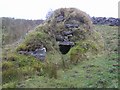
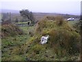
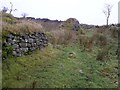
The largest of 3 stone forts (cashels) in the townland is nearly 800 metres N of a former schoolhouse,m and best approached through a farm 400 metres further on, and up a lane. It has a well-preserved lintelled entrance and unusual external stone stairs. Inside are two other stairways. The wall survives up to 3 metres and encloses an area 25 metres in diameter.
450 metres SW, on a rise, is a smaller ruined cashel with a fine, corbelled free-standing sweathouse just inside the entrance.
You may be viewing yesterday's version of this page. To see the most up to date information please register for a free account.
")
Do not use the above information on other web sites or publications without permission of the contributor.
Nearby Images from Geograph Britain and Ireland:
©2008(licence)
©2008(licence)
©2008(licence)
©2008(licence)
©2008(licence)
The above images may not be of the site on this page, they are loaded from Geograph.
Please Submit an Image of this site or go out and take one for us!
Click here to see more info for this site
Nearby sites
Click here to view sites on an interactive map of the areaKey: Red: member's photo, Blue: 3rd party photo, Yellow: other image, Green: no photo - please go there and take one, Grey: site destroyed
Download sites to:
KML (Google Earth)
GPX (GPS waypoints)
CSV (Garmin/Navman)
CSV (Excel)
To unlock full downloads you need to sign up as a Contributory Member. Otherwise downloads are limited to 50 sites.
Turn off the page maps and other distractions
Nearby sites listing. In the following links * = Image available
1.6km ENE 61° Boulder Monument PB46* Natural Stone / Erratic / Other Natural Feature (H0731934670)
1.6km ENE 61° Boulder Monument PB48* Natural Stone / Erratic / Other Natural Feature (H0733234670)
1.8km NE 47° Calf house Portal Tomb* Portal Tomb (H0729535148)
1.8km NE 47° Boulder Grave* Chambered Tomb
2.0km NE 48° Tullygobban Wedge Tomb* Wedge Tomb (H0743435259)
2.3km NE 55° Giants Leap Wedge Tomb* Wedge Tomb (H0787435232)
3.2km E 86° The Dumbies Court Tomb (H09123413)
3.9km N 359° St Brigid' Stones Stone Row / Alignment (H059378)
3.9km N 359° Killinagh* Rock Art (H059378)
5.0km E 89° Tromogagh Stone Circle (H110340)
6.1km N 2° Kilrooskagh Portal Tomb (H06143998)
6.4km NNE 19° Cloghbrack Stone Circle (H080400)
7.6km N 0° Toppan Stone Circle (H060415)
7.7km N 360° Cloghastuckane Stone Circle (H059416)
8.6km NNW 340° Corraderrybrock Stone Circle (H030420)
10.2km NNE 21° Aghanaglack Court Tomb (H096435)
10.8km NW 325° Corracloona* Court Tomb (G997428)
11.1km E 100° Aghatirourke Stone Circle (H1692831965)
12.1km NNE 32° Reyfad Stones Stone Row / Alignment (H124442)
13.1km E 85° Greenan Stone Circle (H190350)
15.3km NNE 33° Ross Lough Crannog (H14294677)
15.8km NW 326° Kilcoo Stone Circle (G970470)
16.0km SW 231° Turlough Stone Row* Standing Stones (G935238)
16.6km N 6° Rossinure More Court Tomb (H07715039)
16.6km N 3° Rossinure Beg Court Tomb (H06915053)
View more nearby sites and additional images


 We would like to know more about this location. Please feel free to add a brief description and any relevant information in your own language.
 Wir möchten mehr über diese Stätte erfahren. Bitte zögern Sie nicht, eine kurze Beschreibung und relevante Informationen in Deutsch hinzuzufügen.
 Nous aimerions en savoir encore un peu sur les lieux. S'il vous plaît n'hesitez pas à ajouter une courte description et tous les renseignements pertinents dans votre propre langue.
 Quisieramos informarnos un poco más de las lugares. No dude en añadir una breve descripción y otros datos relevantes en su propio idioma.