Featured: How and why the ancients enchanted Great Britain and Brittany

How and why the ancients enchanted Great Britain and Brittany

Stone Circles, a Modern Builder's Guide to the Megalithic Revival

Stone Circles, a Modern Builder's Guide to the Megalithic Revival

Who's Online

There are currently, 315 guests and 4 members online.

You are a guest. To join in, please register for free by clicking here

Sponsors

<< Our Photo Pages >> Devil's Arrows - Stone Row / Alignment in England in Yorkshire (North)

Submitted by Andy B on Monday, 25 December 2017  Page Views: 54653

Neolithic and Bronze AgeSite Name: Devil's Arrows Alternative Name: Three Grey Hounds, Three Sisters, Devils Arrows, The Devil's Bolts
Country: England County: Yorkshire (North) Type: Stone Row / Alignment
Nearest Town: Boroughbridge
Map Ref: SE39076659  Landranger Map Number: 99
Latitude: 54.093736N  Longitude: 1.404127W
Condition:
5Perfect
4Almost Perfect
3Reasonable but with some damage
2Ruined but still recognisable as an ancient site
1Pretty much destroyed, possibly visible as crop marks
0No data.
-1Completely destroyed
4 Ambience:
5Superb
4Good
3Ordinary
2Not Good
1Awful
0No data.
3 Access:
5Can be driven to, probably with disabled access
4Short walk on a footpath
3Requiring a bit more of a walk
2A long walk
1In the middle of nowhere, a nightmare to find
0No data.
4 Accuracy:
5co-ordinates taken by GPS or official recorded co-ordinates
4co-ordinates scaled from a detailed map
3co-ordinates scaled from a bad map
2co-ordinates of the nearest village
1co-ordinates of the nearest town
0no data
5

Internal Links:
External Links:

I have visited· I would like to visit

DrewParsons SumDoood whese001 would like to visit

juleslandau visited on 2nd Dec 2023 - their rating: Cond: 4 Amb: 5 Access: 5 Awe inspiring in their immensity and grandeur.

wildtalents visited on 22nd Apr 2023 - their rating: Cond: 4 Amb: 4 Access: 4 On a day when it never stopped raining it was still worth trudging (trespassing) through the farmer's knee-high crops of I don't know what, rather than gazing at the two smaller arrows from afar. The biggest arrow is across the road and mighty impressive. Easy parking at the roadside: the site is now perched on the edge of a modern "little boxes" housing estate.

FranPears visited on 9th Aug 2022 - their rating: Cond: 4 Amb: 3

TheCaptain visited on 13th May 2022 - their rating: Cond: 5 Amb: 4 Access: 5 Its not too far from York, so I went for a look at the Devil's Arrows, which were easy to find. Despite a new housing estate now encroaching and the very nearby A1 and A1(M), these are still at large in fields and feel wild and free. All three stones are magnificent and monsters with interesting rainules running down them. Magnificent.

Richard13 visited on 2nd Jul 2021 - their rating: Cond: 3 Amb: 3 Access: 5 Access and information has improved since my last visit. A new road (Marina Lane) branches off Roecliffe Road on the way into Boroughbridge and this now features a small parking area with an information board about the stones which seems to be aimed at visitors to the Devils Arrows. One of the Arrows sits adjacent to the main road in a small clearing while the two others stand in the field opposite it. All of them can be seen from the new parking spaces and can be walked to. Although the main road into Boroughbridge passes by one stone and the two others are close to the A168 road this does not detract as much as you think it would as the stones are big enough to have an imposing presence of their own. Access to one Arrow is extremely easy as it is next to the road, while access to the others would probably depend more on the state of the crops in the field. This is an excellent site to visit as a break if you are on a car journey up or down the A1(M) and the new layby and information board is a positive development. In spite of this I am sure that many people drive straight past and don't realise that the stones are there

Catrinm visited on 12th Oct 2019 - their rating: Cond: 3 Amb: 4 Access: 5

indigosue visited on 1st Aug 2019 - their rating: Cond: 4 Amb: 3 Access: 4 I've been here a few times when I lived in North Yorkshire and at least twice since I moved to Suffolk. The ambience is not helped by being right next to the A1M, although I used to look for glimpses of the stones when driving past. They are well worth a visit because they are fascinating and awesome. I love the eroded fluted millstone grit look.

Richard13 visited on 1st Jul 2019 - their rating: Cond: 3 Amb: 3 Access: 5

Catrinm visited on 25th Aug 2018 - their rating: Cond: 4 Amb: 4 Access: 5 Impressively large arrows and well preserved. Now next to new housing estate.

SandyG visited on 1st Aug 2017 - their rating: Cond: 4 Amb: 3 Access: 5 There is limited safe parking in the vicinity of the monument.

drolaf visited on 13th Jul 2017 - their rating: Cond: 4 Amb: 4 Access: 4

MartinJEley visited on 4th Apr 2015 - their rating: Cond: 3 Amb: 3 Access: 4 The stones are easily accessed with two standing in a field still in use and the third just across the road. The close alignment is clearly visible. Worth the visit.

kthdsn visited on 20th Jul 2014 - their rating: Cond: 4 Amb: 3 Access: 5

Majick123 visited on 13th Jun 2013 - their rating: Cond: 3 Amb: 4 Access: 5 Beautiful stones. The Main stone is on the main road, with the other 2 remaining stones in the adjacent corn field. Access is good for the two stones in the field, but please respect it is a working field and try not to damage the crop. Once in the Field you can see the alignment of the stones, and the magnificence of the monument.

TheWhiteRider visited on 22nd Jun 2012 - their rating: Cond: 3 Amb: 1 Access: 4

woodini254 visited on 12th May 1997 - their rating: Cond: 4 Amb: 5 Access: 4

Sunny100 visited on 1st Jan 1970 - their rating: Cond: 3 Amb: 4 Access: 5 Fairly easy to get to once out of the town, one next to a house, the other two in a field close by. And yes they are aligned.

Bladup rldixon kelpie nicoladidsbury NickyD have visited here

Average ratings for this site from all visit loggers: Condition: 3.65 Ambience: 3.53 Access: 4.63
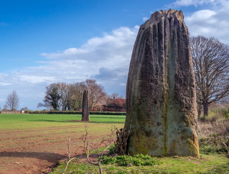
Devil's Arrows
Devil's Arrows submitted by Humbucker : All three Devils Arrows looking from the north. The light improved for a brief few minutes & the sun made a brief appearance while I was there before turning into a flat, grey evening. (Vote or comment on this photo)
Stone Row in North Yorkshire. Three stones remain, the shortest being 5.5m, the tallest stone is 6.8m.

Probably a five-stone row originally. The fourth stone was reputedly broken up in 1582 to build the bridge over the River Tutt, and the fifth is lost in history. The stones are of gritstone, having pointed tops, with a fluted effect caused by weathering, and are buried up to 1.5m into the ground. Dating from the Late Neolithic or Early Bronze Age, the stones were the site of a solstice fair in historical times. Several astronomical alignments have been postulated, as well as a straight ley-type alignment.

The Devils Arrow alignment. Ref: Lines on the Landscape, Devereux and Pennick

Access: Turn off the A1(M) at the A6055 (Boroughbridge) and head into the town. Turn left after the Three Arrows Hotel, down Roecliffe Lane. The stones are a few hundred metres down and unfortunately near to the A1(M) that now bypasses Boroughbridge. The tallest is just off the road to the left, behind a gate. The other two are 200m away on the opposite side of the road, in a cornfield. It is possible to get near the stones by walking down the side of the field, taking care not to trample the corn. Strikingly tall stones. The nearby motorway is not as disturbing as I had expected, due to a high hedge which hides it.

For more information see Pastscape Monument No. 53493 and Historic England List ID 1014705 (Stone alignment west of Boroughbridge known as the Devil's Arrows, including three standing stones and the setting for a fourth), which gives the grid references of the three stones as SE 39071 66588, SE 39099 66531, SE 39152 66430.

The Northern Antiquarian's (TNA) page for Devil’s Arrows, Boroughbridge, North Yorkshire shows the location site on the 1855 OS Map and a drawing of the site from 1895. The Journal of Antiquities also features an entry for the Devil’s Arrows, Boroughbridge, North Yorkshire, which includes a drawing, a photograph of the Arrows and folklore.

Update October 2019: The alignment is also featured on the Stone Rows of Great Britain website - see their entry for the Devil’s Arrows, which includes a description, a plan of the row, photographs of the alignment and the individual stones, access information and links to other online resources for more information. The SRoGB includes a link to 'The Smell of Water: the legend of the Devil's arrows'.

Note: David Parke has made a couple of good 'Monument' podcasts and an audio introduction. One talks to various enthusiasts about the Devil's Arrows, there other is an episode about the Long Man of Wilmington - details in the comments on our pages.
You may be viewing yesterday's version of this page. To see the most up to date information please register for a free account.


Devil's Arrows
Devil's Arrows submitted by AKFisher : Devils Arrows etching by Tony Galuidi. (Vote or comment on this photo)

Devil's Arrows
Devil's Arrows submitted by juleslandau : 6’2” stone botherer dwarfed by the magnificent central megalith on a frosty December morning. (Vote or comment on this photo)

Devil's Arrows
Devil's Arrows submitted by Antonine : It is said that if you walk around any of the stones anti-clockwise twelve times at midnight, the Devil will appear. Photo: looking up at south stone, 2011 (Vote or comment on this photo)

Devil's Arrows
Devil's Arrows submitted by Antonine : There is a legend of how the grooves were made in the stone, which were actually made by centuries of erosion. The story is that the Devil tried to hang his grandmother but she struggled so hard that the ropes cut into the stone. When she broke free he tied her to the next stone. This continued until he ran out of stones to hang her from. Photo: grooves in south stone, 2011 (Vote or comment on this photo)

Devil's Arrows
Devil's Arrows submitted by Antonine : Another legend tells of how a local Chief of the Brigantes tribe held a meeting to discuss the merits of the new Christian religion over the existing, but dying out, Druid system. The Devil arrived in disguise to try to sway the people back to the old Pagan religion, but someone spotted his cloven hooves which were melting the ground beneath him. After being found out, the Devil flew off in a r... (Vote or comment on this photo)

Devil's Arrows
Devil's Arrows submitted by Antonine : There are several legends about the stones associated with the Devil. The most popular legend is that these stones are the Devil’s crossbow bolts. He was aiming for the Christian settlement of Aldborough from Howe Hill but fell short by a mile. Photo: all 3 stones from the shortest, most northerly stone, 2011. The third is just visible in the trees to the left of the second.

Devil's Arrows
Devil's Arrows submitted by Antonine : Each stone weighs approx. 36 - 40 tons. The 2 tallest stones measure 7m high. The stones were transported here around 5000 years ago from Abbey Plain 7 miles away. Photo: central stone, 2011

Devil's Arrows
Devil's Arrows submitted by Antonine : A fourth stone was mentioned in the 16th century. It is thought there were originally 12 stones in a line, perhaps part of a larger complex. Photo: the central stone, 2011

Devil's Arrows
Devil's Arrows submitted by Antonine : The Devil’s Arrows are located east of the A1. Two stones stand in a field west of Chestnut Drive on the north side of Roecliffe Lane. The other stone stands to the south side of Roecliffe Lane. Photo: The 2 stones on the north side of Roecliffe Lane in the field, 2011

Devil's Arrows
Devil's Arrows submitted by Leebrotherton : Centre Stone

Devil's Arrows
Devil's Arrows submitted by Leebrotherton : Cups on Smaller Stone at Night.

Devil's Arrows
Devil's Arrows submitted by FranPears : This is the southernmost stone, easlily accessed behind a gate.

Devil's Arrows
Devil's Arrows submitted by Antonine : 2011

Devil's Arrows
Devil's Arrows submitted by Antonine

Devil's Arrows
Devil's Arrows submitted by Antonine

Devil's Arrows
Devil's Arrows submitted by Richard13 : The Devil's Arrows are all strongly grooved, the result of thousands of years of erosion by the elements. It does add a certain character to them I feel.

Devil's Arrows
Devil's Arrows submitted by Richard13 : A close look at one of the Devil's Arrows. This stone stands directly adjacent to the road into Boroughbridge.

Devil's Arrows
Devil's Arrows submitted by Richard13 : A view of two of the Devil's Arrows seen from the new layby.

Devil's Arrows
Devil's Arrows submitted by Catrinm : Magnificent stone

Devil's Arrows
Devil's Arrows submitted by Humbucker : The northernmost of the three arrows on the field boundary.

Devil's Arrows
Devil's Arrows submitted by Humbucker : The middle arrow which stands in the middle of the cornfield.

Devil's Arrows
Devil's Arrows submitted by Humbucker : The southern arrow all alone in its little enclosure.

Devil's Arrows
Devil's Arrows submitted by Postman : Rows, alignments, should be in a straight line shouldn't they.

Devil's Arrows
Devil's Arrows submitted by Postman : Look like they're in a line don't they? (1 comment)

These are just the first 25 photos of Devil's Arrows. If you log in with a free user account you will be able to see our entire collection.

Do not use the above information on other web sites or publications without permission of the contributor.
Click here to see more info for this site

Nearby sites

Click here to view sites on an interactive OS map

Key: Red: member's photo, Blue: 3rd party photo, Yellow: other image, Green: no photo - please go there and take one, Grey: site destroyed

Download sites to:
KML (Google Earth)
GPX (GPS waypoints)
CSV (Garmin/Navman)
CSV (Excel)

To unlock full downloads you need to sign up as a Contributory Member. Otherwise downloads are limited to 50 sites.

Megalithic Mysteries by Andy Burnham
Stone Pages Tour by Arosio and Meozzi
The Society of Leyhunters by Eric Sargeant
Stone Rows of Great Britain by Sandy Gerrard

Myths and Megaliths by Jim Dyson
Alastair's OTHER Stone Circle Pages by Alastair McIvor
STILE by Clive Ruggles


Turn off the page maps and other distractions

Nearby sites listing. In the following links * = Image available
 1.1km NNW 330° Langthorpe Earthwork Misc. Earthwork (SE38526751)
 2.0km N 8° All Saints (Kirby Hill)* Ancient Cross (SE39326859)
 4.7km SE 133° Duel Cross Hill (Grafton) Cairn (SE426634)
 4.8km SW 216° All Saints (Staveley) Ancient Cross (SE36266266)
 5.2km WSW 238° St Mungo's Well (Copgrove)* Holy Well or Sacred Spring (SE34706378)
 5.6km SW 233° Devil's Stone (Copgrove)* Sculptured Stone (SE346632)
 6.0km NNW 331° Cana Henge Henge (SE36087185)
 6.8km NNW 332° Copt Hewick Cursus Cursus (SE358726)
 6.8km NW 314° St Swithin's Well (Copt Hewick)* Holy Well or Sacred Spring (SE3413271336)
 7.9km NNW 332° Hutton Moor Henge (SE35267353)
 8.4km SE 140° Little Ouseburn Barrow Round Barrow(s) (SE445602)
 8.6km NNE 13° Maiden's Bower (Asenby)* Turf Maze (SE409750)
 8.8km WNW 301° Ripon Cathedral* Ancient Cross (SE31457112)
 9.3km WNW 299° St Wilfrid's Holy Well* Holy Well or Sacred Spring (SE30857102)
 10.5km SSW 196° St Robert's Holy Well (Knaresborough) Holy Well or Sacred Spring (SE36315649)
 10.6km WSW 240° Yarmer Head (Nidd) Standing Stone (Menhir) (SE299612)
 10.6km SSW 206° Mother Shipton's Cave and Petrifying Well * Holy Well or Sacred Spring (SE345570)
 10.7km NW 321° Nunwick Henge Henge (SE3229274837)
 10.9km SSW 196° St Robert's Cave* Cave or Rock Shelter (SE3610556089)
 11.2km WSW 253° Cayton Gill carving* Modern Stone Circle etc (SE284632)
 11.5km W 279° Robin Hood's Well ( Yorkshire)* Holy Well or Sacred Spring (SE2767868295)
 12.3km WSW 241° Weeping Cross* Ancient Cross (SE283605)
 12.4km NNW 329° St Mary (Wath)* Ancient Cross (SE32517715)
 13.3km NW 312° Castle Dikes Hillfort (SE291755)
 13.6km WSW 247° Deb Well* Holy Well or Sacred Spring (SE266611)
View more nearby sites and additional images

<< Tanca 'e Maxia Nuraghe

Middle Rigg round barrows and pit alignment >>

Please add your thoughts on this site

Prehistoric Rock Art in the Northern Dales

Prehistoric Rock Art in the Northern Dales

Web Links for Devil's Arrows

Megalithic Mysteries by Andy Burnham
Stone Pages Tour by Arosio and Meozzi
The Society of Leyhunters by Eric Sargeant
Stone Rows of Great Britain by Sandy Gerrard

Archived Web links for Devil's Arrows

Myths and Megaliths by Jim Dyson
Alastair's OTHER Stone Circle Pages by Alastair McIvor
STILE by Clive Ruggles

Sponsors

Auto-Translation (Google)

Translate from English into:

"Devil's Arrows" | Login/Create an Account | 15 News and Comments
  
Go back to top of page    Comments are owned by the poster. We aren't responsible for their content.
Devil's Arrows new parking layby and information board by Richard13 on Saturday, 03 July 2021
(User Info | Send a Message)
Access and on-site information has now improved for this site!

A road (Marina Lane) branches off Roecliffe Road on the way into Boroughbridge (just after the passing the first stone) and this side road now has a small parking area (it will probably fit 3 cars) with an information board about the stones.
[ Reply to This ]

Devil's Arrows Monument Podcast by Andy B on Tuesday, 19 December 2017
(User Info | Send a Message)
The Devil's Arrows Monument Podcast, which includes a long interview with Gavin who created the 'Smell of Water' blog featured in the previous post
https://soundcloud.com/user-310122391/episode-2-the-devils-arrows

http://monumentpodcast.com/episode%202%20-%20devil's%20arrows.html
More here
http://www.monumentpodcast.com/

Also an episode about the Long Man of Wilmington
http://monumentpodcast.com/episode%201%20-%20the%20long%20man.html
and an introduction
http://monumentpodcast.com/prologue.html
It's not just someone talking - there are some fun audio 'cut ups' as well
[ Reply to This ]

Building work near Devils Arrows by Andy B on Tuesday, 19 December 2017
(User Info | Send a Message)
The Devil’s Arrows are a row of three prehistoric standing stones located in a field on the outskirts of Boroughbridge.

The stones exist in a wider, complex, prehistoric landscape, a recent archaeological survey of the surrounding area uncovered a number of features including a double timber post row and an associated ditch, extensive flint scatters and grooved ware pottery.

Lots of well researched info here

Including "The road beside the field is currently being improved to provide access to a new housing development. It is always a little disturbing to see a development encroaching upon an ancient site."

https://teessidepsychogeography.wordpress.com/2017/11/15/the-devils-arrows-3/

Also here - the legend of the origin of the prehistoric stone row,

https://teessidepsychogeography.wordpress.com/2016/01/17/the-devils-arrows-boroughbridge/
[ Reply to This ]

Devil’s Arrows - Commemorating Ignorance by Andy B on Tuesday, 25 July 2017
(User Info | Send a Message)
Prof. Howard M. R. Williams muses about the rather crap plaque by the third 'arrow'

There is a fourth stone beside the southermost of the Devil’s Arrows. This isn’t brand new, and I suspect it hails from the 1970s or thereabouts. Embedded within it is a light blue disc that might aim to inform the visitor regarding what they are looking at. This blue plaque simply states:

THE DEVIL’S ARROWS
Three pre-historic monolithis
of millstone grit,
probably transported here
from the area of Knaresborough
c. 2700 B.C.

So this is a plaque on a stone referencing stones. To be more precise still, the new stone commemorates the old ones but its really focus of commemoration is ignorance. Here’s why.

Of course this roadside monumental sign doesn’t indicate where the other two Arrows are; they are behind it and across the road behind a hedge and these have no signs. So the first point is that this stone breaks the southernmost away from the others, as much as it joins them together.

The plaque and its stone says next to nothing. No mention of the folklore, no mention of context, no mention of parallels, no comment on meaning or significance past or present. Instead the sign opts for simplisticity: noting where the Arrows might have come from and an extremely odd precise date. Implicitly, it articulates the Arrow’s protected status and physically blocks vehicular access to the stone from the road.

In doing so, the stones are physically protected but also shrouded in ignorance. More still, they are afforded an official stamp of authority that serves to celebrate, even commemorate that ignorance regarding the Devil’s Arrows.

More at
https://howardwilliamsblog.wordpress.com/2017/07/10/devils-arrows-commemorating-ignorance/
[ Reply to This ]

Re: News of Roman ampitheatre near Devil’s Arrows by AngieLake on Thursday, 18 August 2011
(User Info | Send a Message)
"Archaeologists have unearthed a legendary lost amphitheatre on a Yorkshire hilltop.
The summit of Studforth Hill, just outside the village of Aldborough between Harrogate and York, is now home to grazing cattle but was once the largest outdoor arena in northern England."

Read more: http://www.dailymail.co.uk/sciencetech/article-2027370/Lost-Roman-amphitheatre-hilltop-near-Yorkshire-village.html#ixzz1VQ8M3ADg

"Between Ripon and York" would be more accurate. :-)
[ Reply to This ]

A L Lewis, The ‘Devil’s Arrows, Yorkshire, 1879 by Andy B on Friday, 03 June 2011
(User Info | Send a Message)
A[lfred] L[ionel] Lewis, “The ‘Devil’s Arrows’, Yorkshire”
Journal of the Anthropological Institute of Great Britain and Ireland, 1879, 180–183

http://www.cantab.net/users/michael.behrend/repubs/lewis/pages/da.html
[ Reply to This ]

Re: Devils Arrows by coldrum on Monday, 29 March 2010
(User Info | Send a Message)
Street View


View Larger Map
[ Reply to This ]

Re: Devils Arrows by coldrum on Tuesday, 11 August 2009
(User Info | Send a Message)
Pastscape site entry:

http://www.pastscape.org.uk/hob.aspx?hob_id=53493
[ Reply to This ]

Re: Devils Arrows by Thorgrim on Monday, 29 August 2005
(User Info | Send a Message)
Yes - there is a camping and caravanning site very close. Look at an OS map and you will see that it is just the other side of the main road. You go under the underpass towards the village of Roecliff.
[ Reply to This ]

Re: Devils Arrows by Anonymous on Monday, 29 August 2005
can u camp near devils arrows. if u cud reply it would be most helpful
[ Reply to This ]

Re: Devils Arrows by Anonymous on Monday, 03 May 2004
I visited the Devil's Arrows, Boroughbridge, Yorks, on Saturday May 1st, and used my GPS device to mark their exact positions. Satellite reception was good, with an accuracy of around 10ft.


I had been told that the alignment of the stones was "roughly" towards the triple henge site near West Tanfield, some 17km north-west, but when I checked this on MemoryMap, I found that it is quite a bit to the east of this line. In fact, I found that on the alignment of the Devil's Arrows there were THREE OTHER points - marked "Henge, (site of)", just over 6km north-west, (SE33868 75515) due west of Dishforth airfield , and a tumulus and "henge" a couple of kilometres further on (SE35243 73555). Finally, there are a group of tumuli just south of Melmerby (at SE33843 75525).


I have not had time to check out these sites, but I wondered if anyone else has noticed this alignment, and knows of its significance.


I'd be glad to send my GPS data to anyone who wants to check my inferences. so please let me know if you're interested.


Graham Smith
[ Reply to This ]
    Re: Devils Arrows by Anonymous on Saturday, 19 July 2008
    Graham
    Didyou ever find out any more about the henges south of melmerbY?

    Bob Curry
    [ Reply to This ]
    Re: Devils Arrows by Anonymous on Thursday, 06 May 2021
    Graham, you are correct about the alignment, I have found this independently. The alignement to Melmerby is not exact though and I think should be discounted.
    [ Reply to This ]

Re: Devils Arrows by yak on Monday, 06 May 2002
(User Info | Send a Message)
Very impresive huge standing stones. Not very well sign posted as I drove past them twice even though you can see them from the A1(M)! Their condition seems OK considering they are so accessable.
[ Reply to This ]

Your Name: Anonymous [ Register Now ]
Subject:


Add your comment or contribution to this page. Spam or offensive posts are deleted immediately, don't even bother

<<< What is five plus one as a number? (Please type the answer to this question in the little box on the left)
You can also embed videos and other things. For Youtube please copy and paste the 'embed code'.
For Google Street View please include Street View in the text.
Create a web link like this: <a href="https://www.megalithic.co.uk">This is a link</a>  

Allowed HTML is:
<p> <b> <i> <a> <img> <em> <br> <strong> <blockquote> <tt> <li> <ol> <ul> <object> <param> <embed> <iframe>

We would like to know more about this location. Please feel free to add a brief description and any relevant information in your own language.
Wir möchten mehr über diese Stätte erfahren. Bitte zögern Sie nicht, eine kurze Beschreibung und relevante Informationen in Deutsch hinzuzufügen.
Nous aimerions en savoir encore un peu sur les lieux. S'il vous plaît n'hesitez pas à ajouter une courte description et tous les renseignements pertinents dans votre propre langue.
Quisieramos informarnos un poco más de las lugares. No dude en añadir una breve descripción y otros datos relevantes en su propio idioma.