

<< Our Photo Pages >> Bjerkelunden - Barrow Cemetery in Norway in Akershus
Submitted by kenntha88 on Monday, 26 September 2022 Page Views: 344
Neolithic and Bronze AgeSite Name: BjerkelundenCountry: Norway Fylke: Akershus Type: Barrow Cemetery
Nearest Town: Mysen
Latitude: 59.548254N Longitude: 11.334963E
Condition:
| 5 | Perfect |
| 4 | Almost Perfect |
| 3 | Reasonable but with some damage |
| 2 | Ruined but still recognisable as an ancient site |
| 1 | Pretty much destroyed, possibly visible as crop marks |
| 0 | No data. |
| -1 | Completely destroyed |
| 5 | Superb |
| 4 | Good |
| 3 | Ordinary |
| 2 | Not Good |
| 1 | Awful |
| 0 | No data. |
| 5 | Can be driven to, probably with disabled access |
| 4 | Short walk on a footpath |
| 3 | Requiring a bit more of a walk |
| 2 | A long walk |
| 1 | In the middle of nowhere, a nightmare to find |
| 0 | No data. |
| 5 | co-ordinates taken by GPS or official recorded co-ordinates |
| 4 | co-ordinates scaled from a detailed map |
| 3 | co-ordinates scaled from a bad map |
| 2 | co-ordinates of the nearest village |
| 1 | co-ordinates of the nearest town |
| 0 | no data |
Internal Links:
External Links:
")
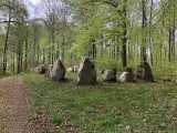
The barrow cemetery consists of 12 round barrows and the remains of a sunken road. It is located on a small plateu overlooking the river to the south. All the barrows are easy to see since they are today a part of a small public park with information poster and picnic and the barrows are covered only with short lawn grass that is beeing regularly cut to make the cemetery more visible to the public.
The 4 largest barrows are located on a line from east to west in the middle of the cemetery at the highest point of the plateau. They all have a diameter of 10-11 metres and height of 1 to 1,5 metres. The 3 southernmost barrows have been damaged over the years and are hardly visible. The rest of the barrows are small, around 6-8 metres in diameter and 0,5 to 1 metre in height. Five of the barrows have craters on the top.
You may be viewing yesterday's version of this page. To see the most up to date information please register for a free account.
")
")
")
")
")
")
")
")
")
")
Do not use the above information on other web sites or publications without permission of the contributor.
Click here to see more info for this site
Nearby sites
Click here to view sites on an interactive map of the areaKey: Red: member's photo, Blue: 3rd party photo, Yellow: other image, Green: no photo - please go there and take one, Grey: site destroyed
Download sites to:
KML (Google Earth)
GPX (GPS waypoints)
CSV (Garmin/Navman)
CSV (Excel)
To unlock full downloads you need to sign up as a Contributory Member. Otherwise downloads are limited to 50 sites.
Turn off the page maps and other distractions
Nearby sites listing. In the following links * = Image available
2.4km NNW 334° Ospeveien* Round Barrow(s)
3.8km NW 316° Monaryggen* Barrow Cemetery
4.7km SSE 166° Trømborg* Barrow Cemetery
8.7km NE 41° Festningsåsen* Hillfort
9.2km NNE 30° Trolldansen* Stone Circle
9.2km WNW 290° Neverstien-Løken Søndre* Round Barrow(s)
9.4km NNE 14° Bæljeråsen* Hillfort
9.8km WNW 302° Grøttvet Nordre* Stone Circle
9.9km WNW 290° Somerrogata-Løkentunet* Round Barrow(s)
10.3km WNW 298° Museumsveien* Round Barrow(s)
10.7km WNW 294° Askim Fylkessykehusets Park* Barrow Cemetery
10.8km WNW 293° Askim Folkepark Cemetery* Barrow Cemetery
11.6km NW 305° Haraldstad Mound* Round Barrow(s)
11.7km WNW 298° Offeret* Stone Circle
12.7km SW 225° Skiptvet Church cup Mark* Carving
13.5km WNW 290° Romskollen* Hillfort
13.9km NNE 19° Nordbråte* Stone Circle
14.1km NNE 19° Gukil* Natural Stone / Erratic / Other Natural Feature
14.4km SSW 194° Sæevisslottet* Hillfort
14.7km SW 219° Kransrud-Borgåsen* Hillfort
16.7km S 171° Bjørnstad* Rock Art
17.9km WNW 301° Hylligraven* Passage Grave
18.3km NW 310° Olafsrud-Slottsåsen Hillfort* Hillfort
20.9km S 181° Øverby Runestone* Carving
22.1km W 266° Bjørnefestningen* Hillfort
View more nearby sites and additional images


 We would like to know more about this location. Please feel free to add a brief description and any relevant information in your own language.
 Wir möchten mehr über diese Stätte erfahren. Bitte zögern Sie nicht, eine kurze Beschreibung und relevante Informationen in Deutsch hinzuzufügen.
 Nous aimerions en savoir encore un peu sur les lieux. S'il vous plaît n'hesitez pas à ajouter une courte description et tous les renseignements pertinents dans votre propre langue.
 Quisieramos informarnos un poco más de las lugares. No dude en añadir una breve descripción y otros datos relevantes en su propio idioma.