

<< Our Photo Pages >> Tomb of King Gihon - Cist in Japan in Kyūshū
Submitted by Aska on Sunday, 10 October 2021 Page Views: 494
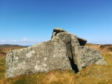
Modern SitesSite Name: Tomb of King Gihon Alternative Name: 義本王墓 Gihon’ō-no-haka Gihonō-no-haka Gihono-no-hakaCountry: Japan Region: Kyūshū Type: Cist
Nearest Town: Kunigami-son (Okinawa prefecture) Nearest Village: Hedo 辺戸
Latitude: 26.858920N Longitude: 128.260560E
Condition:
| 5 | Perfect |
| 4 | Almost Perfect |
| 3 | Reasonable but with some damage |
| 2 | Ruined but still recognisable as an ancient site |
| 1 | Pretty much destroyed, possibly visible as crop marks |
| 0 | No data. |
| -1 | Completely destroyed |
| 5 | Superb |
| 4 | Good |
| 3 | Ordinary |
| 2 | Not Good |
| 1 | Awful |
| 0 | No data. |
| 5 | Can be driven to, probably with disabled access |
| 4 | Short walk on a footpath |
| 3 | Requiring a bit more of a walk |
| 2 | A long walk |
| 1 | In the middle of nowhere, a nightmare to find |
| 0 | No data. |
| 5 | co-ordinates taken by GPS or official recorded co-ordinates |
| 4 | co-ordinates scaled from a detailed map |
| 3 | co-ordinates scaled from a bad map |
| 2 | co-ordinates of the nearest village |
| 1 | co-ordinates of the nearest town |
| 0 | no data |
Internal Links:
External Links:
")
You may be viewing yesterday's version of this page. To see the most up to date information please register for a free account.
Do not use the above information on other web sites or publications without permission of the contributor.
Nearby Images from Flickr


The above images may not be of the site on this page, but were taken nearby. They are loaded from Flickr so please click on them for image credits.
Click here to see more info for this site
Nearby sites
Click here to view sites on an interactive map of the areaKey: Red: member's photo, Blue: 3rd party photo, Yellow: other image, Green: no photo - please go there and take one, Grey: site destroyed
Download sites to:
KML (Google Earth)
GPX (GPS waypoints)
CSV (Garmin/Navman)
CSV (Excel)
To unlock full downloads you need to sign up as a Contributory Member. Otherwise downloads are limited to 50 sites.
Turn off the page maps and other distractions
Nearby sites listing. In the following links * = Image available
13.0km SSW 212° Iji Tōmiyā* Stone Circle
26.0km NE 42° Ishuburi-baka* Rock Cut Tomb
26.1km NE 39° Noroshi-dai (in Yoron-jima island)* Artificial Mound
29.4km SW 235° Kouri Tūmiyā* Natural Stone / Erratic / Other Natural Feature
31.3km WNW 282° Izena Tamaudun* Chambered Tomb
32.0km WNW 282° Kurautchi-baka* Chambered Tomb
32.1km SW 232° Mumujana-baka* Rock Cut Tomb
32.1km SW 232° Ūnishi-baka* Rock Cut Tomb
32.8km WNW 283° Āga-yama* Artificial Mound
34.5km WSW 239° Ichigusuku-baka* Rock Cut Tomb
37.7km WSW 240° Nakijin-jō* Hillfort
46.5km WSW 253° Kadabaru cave* Cave or Rock Shelter
49.5km WSW 251° MinkaZantū* Holy Well or Sacred Spring
49.9km WSW 253° Gohezu cave* Cave or Rock Shelter
52.4km WSW 252° Amibōsha* Stone Circle
59.1km SSW 207° Usumē Hāmē* Standing Stones
61.0km NNE 28° Yakomo Sējima Kofun* Rock Cut Tomb
61.8km SSW 206° Uehara Hītachī* Misc. Earthwork
62.1km NNE 25° Ubusu* Broch or Nuraghe
64.5km NNE 31° Yaja Masabaru Ryūkyū-shiki Fumbo* Chambered Tomb
65.5km SW 222° Iha Nūru-baka* Rock Cut Tomb
67.0km SW 218° Agena-jō* Hillfort
67.0km NNE 30° ĀniMagaya Tūru-baka* Chambered Tomb
67.2km NNE 27° Shinjō Hanakubo Nyāto-baka* Chambered Tomb
67.8km NNE 31° Chura-dūru* Chambered Tomb
View more nearby sites and additional images


 We would like to know more about this location. Please feel free to add a brief description and any relevant information in your own language.
 Wir möchten mehr über diese Stätte erfahren. Bitte zögern Sie nicht, eine kurze Beschreibung und relevante Informationen in Deutsch hinzuzufügen.
 Nous aimerions en savoir encore un peu sur les lieux. S'il vous plaît n'hesitez pas à ajouter une courte description et tous les renseignements pertinents dans votre propre langue.
 Quisieramos informarnos un poco más de las lugares. No dude en añadir una breve descripción y otros datos relevantes en su propio idioma.