

<< Text Pages >> Schalenstein Neverin 1 - Rock Art in Germany in Mecklenburg-Western Pomerania
Submitted by KaiHofmann on Sunday, 05 September 2021 Page Views: 187
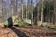
Rock ArtSite Name: Schalenstein Neverin 1Country: Germany Land: Mecklenburg-Western Pomerania Type: Rock Art
Nearest Town: Neubrandenburg Nearest Village: Neverin
Latitude: 53.614017N Longitude: 13.315867E
Condition:
| 5 | Perfect |
| 4 | Almost Perfect |
| 3 | Reasonable but with some damage |
| 2 | Ruined but still recognisable as an ancient site |
| 1 | Pretty much destroyed, possibly visible as crop marks |
| 0 | No data. |
| -1 | Completely destroyed |
| 5 | Superb |
| 4 | Good |
| 3 | Ordinary |
| 2 | Not Good |
| 1 | Awful |
| 0 | No data. |
| 5 | Can be driven to, probably with disabled access |
| 4 | Short walk on a footpath |
| 3 | Requiring a bit more of a walk |
| 2 | A long walk |
| 1 | In the middle of nowhere, a nightmare to find |
| 0 | No data. |
| 5 | co-ordinates taken by GPS or official recorded co-ordinates |
| 4 | co-ordinates scaled from a detailed map |
| 3 | co-ordinates scaled from a bad map |
| 2 | co-ordinates of the nearest village |
| 1 | co-ordinates of the nearest town |
| 0 | no data |
Be the first person to rate this site - see the 'Contribute!' box in the right hand menu.
Internal Links:
External Links:
Rock Art in Mecklenburg-Western Pomerania
cup marked stone.
You may be viewing yesterday's version of this page. To see the most up to date information please register for a free account.
Do not use the above information on other web sites or publications without permission of the contributor.
Nearby Images from Flickr
The above images may not be of the site on this page, but were taken nearby. They are loaded from Flickr so please click on them for image credits.
Click here to see more info for this site
Nearby sites
Click here to view sites on an interactive map of the areaKey: Red: member's photo, Blue: 3rd party photo, Yellow: other image, Green: no photo - please go there and take one, Grey: site destroyed
Download sites to:
KML (Google Earth)
GPX (GPS waypoints)
CSV (Garmin/Navman)
CSV (Excel)
To unlock full downloads you need to sign up as a Contributory Member. Otherwise downloads are limited to 50 sites.
Turn off the page maps and other distractions
Nearby sites listing. In the following links * = Image available
137m E 93° Schalenstein Neverin 2 Rock Art
2.9km N 6° Schalenstein Hohenmin Rock Art
4.5km S 182° Ravensburg Neubrandenburg Ancient Village or Settlement
5.1km N 358° Hügelgrab Ganzkow 6* Round Barrow(s)
6.0km NE 50° Roggenhagen (1)* Chambered Tomb
6.0km NE 50° Roggenhagen (2)* Chambered Tomb
6.9km WSW 245° Riesenstein Krappmühle* Rock Art
7.5km SSW 212° Museum Neubrandenburg* Museum
8.6km SSW 209° Steinkisten Kulturpark* Cist
9.8km NE 39° Hügelgräber Brunn 2* Barrow Cemetery
10.1km S 186° Grosser Stein Neubrandenburg Rock Art
10.3km NNW 336° Grosser Stein Altentreptow* Natural Stone / Erratic / Other Natural Feature
10.6km E 85° Genzkow Steingrab 3 Chambered Tomb
11.7km SSW 207° Großsteingrab Neubrandenburg* Burial Chamber or Dolmen
12.2km WSW 248° De groote Stein Chemnitz Natural Stone / Erratic / Other Natural Feature
13.0km ENE 75° Genzkow Steingrab 2 Chambered Tomb
13.2km NNW 346° Hügelgrab Mühlenhagen 1 Round Barrow(s)
13.4km NE 36° Schwanbeck (3) Chambered Tomb
13.5km ENE 57° Großsteingrab Dorf Salow* Burial Chamber or Dolmen
13.7km E 80° Genzkow Steingrab 1* Chambered Tomb
13.7km NNE 27° Siedenbollentin (1) Round Barrow(s)
14.7km NNE 28° Schwanbeck (4)* Chambered Tomb
14.8km NNE 28° Schwanbeck (25)* Chambered Tomb
14.9km N 359° Grosssteingrab Wodarg 1 Burial Chamber or Dolmen
14.9km N 359° Grosssteingrab Wodarg 2 Burial Chamber or Dolmen
View more nearby sites and additional images


 We would like to know more about this location. Please feel free to add a brief description and any relevant information in your own language.
 Wir möchten mehr über diese Stätte erfahren. Bitte zögern Sie nicht, eine kurze Beschreibung und relevante Informationen in Deutsch hinzuzufügen.
 Nous aimerions en savoir encore un peu sur les lieux. S'il vous plaît n'hesitez pas à ajouter une courte description et tous les renseignements pertinents dans votre propre langue.
 Quisieramos informarnos un poco más de las lugares. No dude en añadir una breve descripción y otros datos relevantes en su propio idioma.