 with our Megalithic Portal iPhone app")

<< Our Photo Pages >> Hügelgrab Ganzkow 6 - Round Barrow(s) in Germany in Mecklenburg-Western Pomerania
Submitted by Boeddel on Tuesday, 23 February 2021 Page Views: 290
Neolithic and Bronze AgeSite Name: Hügelgrab Ganzkow 6Country: Germany Land: Mecklenburg-Western Pomerania Type: Round Barrow(s)
Nearest Town: Altentreptow Nearest Village: Ganzkow
Latitude: 53.659934N Longitude: 13.313539E
Condition:
| 5 | Perfect |
| 4 | Almost Perfect |
| 3 | Reasonable but with some damage |
| 2 | Ruined but still recognisable as an ancient site |
| 1 | Pretty much destroyed, possibly visible as crop marks |
| 0 | No data. |
| -1 | Completely destroyed |
| 5 | Superb |
| 4 | Good |
| 3 | Ordinary |
| 2 | Not Good |
| 1 | Awful |
| 0 | No data. |
| 5 | Can be driven to, probably with disabled access |
| 4 | Short walk on a footpath |
| 3 | Requiring a bit more of a walk |
| 2 | A long walk |
| 1 | In the middle of nowhere, a nightmare to find |
| 0 | No data. |
| 5 | co-ordinates taken by GPS or official recorded co-ordinates |
| 4 | co-ordinates scaled from a detailed map |
| 3 | co-ordinates scaled from a bad map |
| 2 | co-ordinates of the nearest village |
| 1 | co-ordinates of the nearest town |
| 0 | no data |
Internal Links:
External Links:
I have visited· I would like to visit
Boeddel visited on 23rd Feb 2021 Unfortunately I couldn't find the cup marked stone there on the burial mound.
")
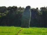
A bronze age burial mound approx. 2 m high and 17 m in diameter.
According to a list of ancient monuments, there should be a cup-marked stone with 14 cup marks on top of the mound. Unfortunately I didn't find the stone. The burial mound has many animal burrows.
You may be viewing yesterday's version of this page. To see the most up to date information please register for a free account.
")
")
")
")
")
")
")
Do not use the above information on other web sites or publications without permission of the contributor.
Click here to see more info for this site
Nearby sites
Click here to view sites on an interactive map of the areaKey: Red: member's photo, Blue: 3rd party photo, Yellow: other image, Green: no photo - please go there and take one, Grey: site destroyed
Download sites to:
KML (Google Earth)
GPX (GPS waypoints)
CSV (Garmin/Navman)
CSV (Excel)
To unlock full downloads you need to sign up as a Contributory Member. Otherwise downloads are limited to 50 sites.
Turn off the page maps and other distractions
Nearby sites listing. In the following links * = Image available
2.2km SSE 169° Schalenstein Hohenmin Rock Art
4.9km ESE 105° Roggenhagen (1)* Chambered Tomb
4.9km ESE 105° Roggenhagen (2)* Chambered Tomb
5.1km S 178° Schalenstein Neverin 1 Rock Art
5.1km S 177° Schalenstein Neverin 2 Rock Art
5.9km NW 317° Grosser Stein Altentreptow* Natural Stone / Erratic / Other Natural Feature
6.8km ENE 69° Hügelgräber Brunn 2* Barrow Cemetery
8.3km NNW 338° Hügelgrab Mühlenhagen 1 Round Barrow(s)
9.5km NE 41° Siedenbollentin (1) Round Barrow(s)
9.6km S 180° Ravensburg Neubrandenburg Ancient Village or Settlement
9.8km N 360° Grosssteingrab Wodarg 1 Burial Chamber or Dolmen
9.8km N 360° Grosssteingrab Wodarg 2 Burial Chamber or Dolmen
9.9km NE 55° Schwanbeck (3) Chambered Tomb
9.9km N 4° Schalenstein Wodarg* Rock Art
9.9km N 4° Grosssteingrab Wodarg 3 Burial Chamber or Dolmen
9.9km N 358° Schlachtfeld Tollensetal* Not Known (by us)
10.1km SW 217° Riesenstein Krappmühle* Rock Art
10.6km NE 42° Schwanbeck (4)* Chambered Tomb
10.7km NE 42° Schwanbeck (25)* Chambered Tomb
11.5km ESE 111° Genzkow Steingrab 3 Chambered Tomb
11.7km E 79° Großsteingrab Dorf Salow* Burial Chamber or Dolmen
11.9km NE 38° Siedenbollentin (3) Chambered Tomb
12.1km SSW 199° Museum Neubrandenburg* Museum
12.1km NE 37° Siedenbollentin (2) Chambered Tomb
12.3km ENE 57° Dishley (2)* Chambered Tomb
View more nearby sites and additional images


 We would like to know more about this location. Please feel free to add a brief description and any relevant information in your own language.
 Wir möchten mehr über diese Stätte erfahren. Bitte zögern Sie nicht, eine kurze Beschreibung und relevante Informationen in Deutsch hinzuzufügen.
 Nous aimerions en savoir encore un peu sur les lieux. S'il vous plaît n'hesitez pas à ajouter une courte description et tous les renseignements pertinents dans votre propre langue.
 Quisieramos informarnos un poco más de las lugares. No dude en añadir una breve descripción y otros datos relevantes en su propio idioma.