

<< Our Photo Pages >> Anta da Lameira Travessa - Cist in Portugal in Viseu
Submitted by ShamrockStone on Tuesday, 09 July 2019 Page Views: 959
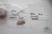
Neolithic and Bronze AgeSite Name: Anta da Lameira TravessaCountry: Portugal Distrito: Viseu Type: Cist
Nearest Village: Pendilhe
Latitude: 40.906270N Longitude: 7.8215W
Condition:
| 5 | Perfect |
| 4 | Almost Perfect |
| 3 | Reasonable but with some damage |
| 2 | Ruined but still recognisable as an ancient site |
| 1 | Pretty much destroyed, possibly visible as crop marks |
| 0 | No data. |
| -1 | Completely destroyed |
| 5 | Superb |
| 4 | Good |
| 3 | Ordinary |
| 2 | Not Good |
| 1 | Awful |
| 0 | No data. |
| 5 | Can be driven to, probably with disabled access |
| 4 | Short walk on a footpath |
| 3 | Requiring a bit more of a walk |
| 2 | A long walk |
| 1 | In the middle of nowhere, a nightmare to find |
| 0 | No data. |
| 5 | co-ordinates taken by GPS or official recorded co-ordinates |
| 4 | co-ordinates scaled from a detailed map |
| 3 | co-ordinates scaled from a bad map |
| 2 | co-ordinates of the nearest village |
| 1 | co-ordinates of the nearest town |
| 0 | no data |
Internal Links:
External Links:
")
Anta da Lameira Travessa is located just outside the domains of the Quinta Pedras Bem Feitas. There is a lot of construction at the moment (June 2019), it can be a bit difficult to get to the site. Enter the dirt road at 40.90087N, 7.81865W. Close by are a few other megalithic sites (see nearby sites below).
You may be viewing yesterday's version of this page. To see the most up to date information please register for a free account.
")
Do not use the above information on other web sites or publications without permission of the contributor.
Nearby Images from Flickr


The above images may not be of the site on this page, but were taken nearby. They are loaded from Flickr so please click on them for image credits.
Click here to see more info for this site
Nearby sites
Click here to view sites on an interactive map of the areaKey: Red: member's photo, Blue: 3rd party photo, Yellow: other image, Green: no photo - please go there and take one, Grey: site destroyed
Download sites to:
KML (Google Earth)
GPX (GPS waypoints)
CSV (Garmin/Navman)
CSV (Excel)
To unlock full downloads you need to sign up as a Contributory Member. Otherwise downloads are limited to 50 sites.
Turn off the page maps and other distractions
Nearby sites listing. In the following links * = Image available
242m SSE 150° Anta Pedras Bem Feitas* Modern Stone Circle etc
300m SSE 164° Anta Travessas da Orca 2* Cist
342m SSE 161° Anta Travessas da Orca 1* Cist
911m NNW 335° Orca da Rapadouro 3* Cist
922m SSW 191° Anta de Pendilhe* Burial Chamber or Dolmen
924m NNW 333° Orca da Rapadouro 1* Cist
925m NNW 331° Orca da Rapadouro 2* Burial Chamber or Dolmen
1.2km ESE 116° Orca do Picoto do Vasco* Burial Chamber or Dolmen
5.6km SSE 163° Castro de Vila Cova à Coelheira Castro or Chafurdão
10.2km SSE 160° Orca Vale dos Carris* Burial Chamber or Dolmen
10.4km SSE 149° Orca da Corga dos Moços* Burial Chamber or Dolmen
11.6km SE 126° Orca de Porto Lamoso* Burial Chamber or Dolmen
12.0km ENE 71° Orca da Carqueja Passage Grave
12.2km ENE 69° Orca de Seixas Passage Grave
12.4km ENE 68° Orca da Fonte do Rato Burial Chamber or Dolmen
12.5km ENE 71° Orca Grande Burial Chamber or Dolmen
12.6km SE 143° Orca dos Juncais* Burial Chamber or Dolmen
12.7km SE 133° Anta de Cas-Freires* Burial Chamber or Dolmen
12.8km ENE 69° Orca do Bebedouro 1 Burial Chamber or Dolmen
13.1km SE 133° Orca do Tanque 2* Burial Chamber or Dolmen
13.2km ENE 73° Estátua-Menir da Nave Standing Stone (Menhir)
14.9km ESE 117° Orca de Forlés* Burial Chamber or Dolmen
17.6km NNW 329° Recinto Megalítico de São Cristóvão* Burial Chamber or Dolmen
19.0km ENE 62° Parque de Lazer* Modern Stone Circle etc
20.2km NNW 339° Mamoa de Moumiz Rock Outcrop
View more nearby sites and additional images


 We would like to know more about this location. Please feel free to add a brief description and any relevant information in your own language.
 Wir möchten mehr über diese Stätte erfahren. Bitte zögern Sie nicht, eine kurze Beschreibung und relevante Informationen in Deutsch hinzuzufügen.
 Nous aimerions en savoir encore un peu sur les lieux. S'il vous plaît n'hesitez pas à ajouter une courte description et tous les renseignements pertinents dans votre propre langue.
 Quisieramos informarnos un poco más de las lugares. No dude en añadir una breve descripción y otros datos relevantes en su propio idioma.