


<< Text Pages >> Menhir du Bois du Couedic - Standing Stone (Menhir) in France in Bretagne:Côtes-D'Armor (22)
Submitted by holger_rix on Tuesday, 31 May 2016 Page Views: 807
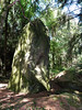
Neolithic and Bronze AgeSite Name: Menhir du Bois du CouedicCountry: France Département: Bretagne:Côtes-D'Armor (22) Type: Standing Stone (Menhir)
Nearest Town: Loudéac Nearest Village: Saint-Mayeux
Latitude: 48.254938N Longitude: 3.047661W
Condition:
| 5 | Perfect |
| 4 | Almost Perfect |
| 3 | Reasonable but with some damage |
| 2 | Ruined but still recognisable as an ancient site |
| 1 | Pretty much destroyed, possibly visible as crop marks |
| 0 | No data. |
| -1 | Completely destroyed |
| 5 | Superb |
| 4 | Good |
| 3 | Ordinary |
| 2 | Not Good |
| 1 | Awful |
| 0 | No data. |
| 5 | Can be driven to, probably with disabled access |
| 4 | Short walk on a footpath |
| 3 | Requiring a bit more of a walk |
| 2 | A long walk |
| 1 | In the middle of nowhere, a nightmare to find |
| 0 | No data. |
| 5 | co-ordinates taken by GPS or official recorded co-ordinates |
| 4 | co-ordinates scaled from a detailed map |
| 3 | co-ordinates scaled from a bad map |
| 2 | co-ordinates of the nearest village |
| 1 | co-ordinates of the nearest town |
| 0 | no data |
Be the first person to rate this site - see the 'Contribute!' box in the right hand menu.
Internal Links:
External Links:
Standing Stone (Menhir) in Bretagne:Côtes-D'Armor (22)
Saint-Mayeux, Loudéac, Côtes-d'Armor, Brittany
Source: T4T35
Information and Pictures:
megalithes-breton.fr
You may be viewing yesterday's version of this page. To see the most up to date information please register for a free account.
Do not use the above information on other web sites or publications without permission of the contributor.
Nearby Images from Flickr
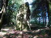
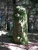

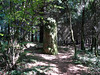
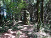
The above images may not be of the site on this page, but were taken nearby. They are loaded from Flickr so please click on them for image credits.
Click here to see more info for this site
Nearby sites
Click here to view sites on an interactive map of the areaKey: Red: member's photo, Blue: 3rd party photo, Yellow: other image, Green: no photo - please go there and take one, Grey: site destroyed
Download sites to:
KML (Google Earth)
GPX (GPS waypoints)
CSV (Garmin/Navman)
CSV (Excel)
To unlock full downloads you need to sign up as a Contributory Member. Otherwise downloads are limited to 50 sites.
Turn off the page maps and other distractions
Nearby sites listing. In the following links * = Image available
300m NE 45° Menhir de Kercouedic Standing Stone (Menhir)
330m SW 234° Menhir de Kerjégu Standing Stone (Menhir)
811m WNW 290° Site néolithique de Quelfenec* Ancient Mine, Quarry or other Industry
879m S 183° Allée Couverte de Crampoazic Passage Grave
909m ENE 57° Menhir de Bourlousson* Standing Stone (Menhir)
1.3km ENE 75° Roc'h ar Lein Menhir* Standing Stone (Menhir)
1.6km ENE 70° Saint-Mayeux allée couverte* Passage Grave
1.6km ENE 64° Mein El Has* Standing Stone (Menhir)
3.3km E 89° Menhir de Saint-Mayeux* Standing Stone (Menhir)
3.3km SSE 153° Ty-Min menhir* Standing Stone (Menhir)
3.4km SSE 148° Porz Guillo menhir* Standing Stone (Menhir)
4.2km SSE 149° Coët Correc allée couverte* Passage Grave
4.3km SE 137° Allée couverte de Corn-er-Houët* Passage Grave
4.9km W 260° Menhir de la Chapelle Saint-Gildas* Standing Stone (Menhir)
5.0km WSW 257° St Gildas Well (Laniscat)* Holy Well or Sacred Spring
6.4km E 98° Callac Menhir* Standing Stone (Menhir)
6.5km WSW 240° Menhirs de Canac'h Léron* Standing Stones
7.0km SSE 166° Camp dit du Castel-Finans Ancient Village or Settlement
7.1km WSW 237° Liscuis 1 allée couverte* Passage Grave
7.1km WSW 238° Liscuis 2 allée couverte* Passage Grave
7.2km WSW 238° Liscuis 3 allée couverte* Passage Grave
9.2km SSW 193° Pierre de Guergadic* Standing Stone (Menhir)
9.3km SE 124° Menhir de Botrain Standing Stone (Menhir)
9.6km SE 144° Menhir de Botconnaire Standing Stone (Menhir)
10.1km S 190° Bugul er Hoët Menhir* Standing Stone (Menhir)
View more nearby sites and additional images


 We would like to know more about this location. Please feel free to add a brief description and any relevant information in your own language.
 Wir möchten mehr über diese Stätte erfahren. Bitte zögern Sie nicht, eine kurze Beschreibung und relevante Informationen in Deutsch hinzuzufügen.
 Nous aimerions en savoir encore un peu sur les lieux. S'il vous plaît n'hesitez pas à ajouter une courte description et tous les renseignements pertinents dans votre propre langue.
 Quisieramos informarnos un poco más de las lugares. No dude en añadir una breve descripción y otros datos relevantes en su propio idioma.