<< Our Photo Pages >> Randolphfield Stones - Standing Stones in Scotland in Stirling
Submitted by rogerkread on Wednesday, 11 January 2017 Page Views: 8165
Neolithic and Bronze AgeSite Name: Randolphfield StonesCountry: Scotland County: Stirling Type: Standing Stones
Nearest Town: Stirling
Map Ref: NS79449244
Latitude: 56.109454N Longitude: 3.940197W
Condition:
| 5 | Perfect |
| 4 | Almost Perfect |
| 3 | Reasonable but with some damage |
| 2 | Ruined but still recognisable as an ancient site |
| 1 | Pretty much destroyed, possibly visible as crop marks |
| 0 | No data. |
| -1 | Completely destroyed |
| 5 | Superb |
| 4 | Good |
| 3 | Ordinary |
| 2 | Not Good |
| 1 | Awful |
| 0 | No data. |
| 5 | Can be driven to, probably with disabled access |
| 4 | Short walk on a footpath |
| 3 | Requiring a bit more of a walk |
| 2 | A long walk |
| 1 | In the middle of nowhere, a nightmare to find |
| 0 | No data. |
| 5 | co-ordinates taken by GPS or official recorded co-ordinates |
| 4 | co-ordinates scaled from a detailed map |
| 3 | co-ordinates scaled from a bad map |
| 2 | co-ordinates of the nearest village |
| 1 | co-ordinates of the nearest town |
| 0 | no data |
Internal Links:
External Links:
I have visited· I would like to visit
Anne T visited on 30th Oct 2018 - their rating: Cond: 3 Amb: 3 Access: 4 Randolphfield Stones, Sterling: This visit felt really strange, as the stones were literally in front of the police station, and I wondered if I’d get a tap on the shoulder and the memory card from my camera confiscated! No one seemed to turn a hair, though I took a number of photographs of both stones.

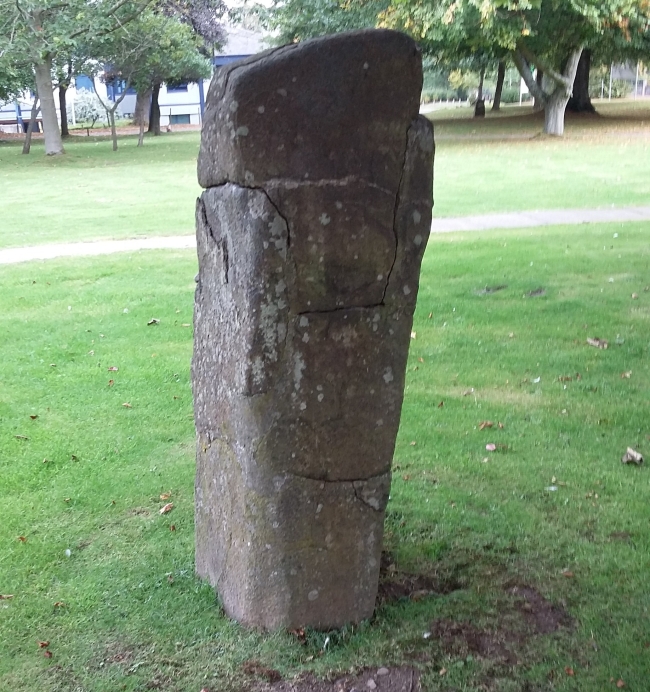
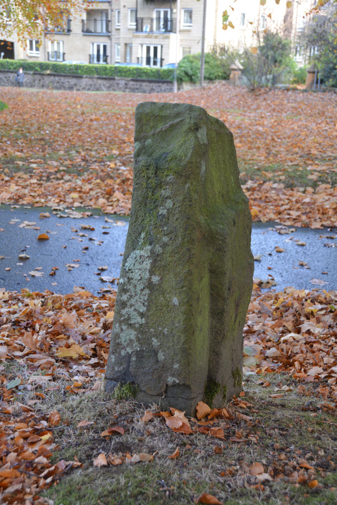
The stones are on the grassy forecourt in front of the main police station, on the right hand side of the B8051 heading SW from the town centre. There are two stones about 50 yards apart.
Local folklore links them with commemmoration of Bannockburn and an encounter the evening before between Randolph Earl of Moray and an English general. The second event is unlikely as the name Randolph Field for the area is not recorded until the end of the 18th Century.
For more information see Canmore ID 46226, an extract of which reads: "These stones may have been there prior to the skirmish or have been erected in commemoration of it. At least one stone (to the SW) was moved in the 20th century ahead of the construction of the current Police HQ. A series of hand dug test pits, excavated 29–31 May 2014, failed to identify either prehistoric or medieval material. However, a slot against the second stone to the NE confirmed that it had not been moved in the recent past and may be in situ."
An entry from 1963, taken from an 1880 source says: "Stone 'A' is an upright rectangular pillar, 4' high and measuring 2' by 1'6" at ground level. Stone 'B' also an upright rectangular pillar, is 3'8" high and 1'5" by 1' at ground level."
The Northern Antiquarian (TNA) also features a page for these standing stones - see their entry for Randolphfield, Stirling, Stirlingshire, which gives directions for finding these stones (described as easy to find), an image of the 1820 OS map showing the location of these stones, recent photographs, a brief archaeology & history and local folklore.
Note: Excavation and dating links the Randolphfield Stones to the 1314 battle Battle of Bannockburn
You may be viewing yesterday's version of this page. To see the most up to date information please register for a free account.


Do not use the above information on other web sites or publications without permission of the contributor.
Click here to see more info for this site
Nearby sites
Key: Red: member's photo, Blue: 3rd party photo, Yellow: other image, Green: no photo - please go there and take one, Grey: site destroyed
Download sites to:
KML (Google Earth)
GPX (GPS waypoints)
CSV (Garmin/Navman)
CSV (Excel)
To unlock full downloads you need to sign up as a Contributory Member. Otherwise downloads are limited to 50 sites.
Turn off the page maps and other distractions
Nearby sites listing. In the following links * = Image available
362m E 100° Wester Livilands* Broch or Nuraghe (NS7979692369)
623m NNE 22° St Ninian's Well (Stirling)* Holy Well or Sacred Spring (NS7969093012)
1.1km W 279° Coneypark Nursery (Cambusbarron)* Cairn (NS78409263)
1.2km WNW 296° King's Park Cup and Rings* Rock Art (NS7837892998)
1.3km WNW 289° Douglas Terrace (Cambusbarron) Cairn (NS782929)
1.4km W 275° Birkill House Cairn (NS780926)
1.5km NNW 339° Butt Well* Holy Well or Sacred Spring (NS78949389)
1.6km W 271° Chapel Well (Cambusbarron)* Holy Well or Sacred Spring (NS77819251)
1.7km WNW 290° St Thomas's Well (Cambusbarron)* Holy Well or Sacred Spring (NS7788493056)
2.0km SW 231° Boiling Springs (Cambusbarron) Holy Well or Sacred Spring (NS77879124)
2.1km N 355° Our Lady's Well (Stirling) Holy Well or Sacred Spring (NS79329454)
2.5km SW 230° Wallstale Dun* Stone Fort or Dun (NS77449085)
2.7km WSW 254° Gillies Hill* Hillfort (NS76879176)
3.1km SE 135° St Ninians Cursus Cursus (NS81599016)
3.2km SE 135° St Ninians Cursus Cursus (NS81679012)
3.2km SW 234° Wester Craigend Dun* Stone Fort or Dun (NS7677790621)
3.2km WSW 239° Castlehill Dun* Stone Fort or Dun (NS76619084)
3.5km NNE 16° Bel Stane (Causewayhead) Standing Stone (Menhir) (NS805958)
3.5km NNE 23° Abbey Craig Vitrified Fort* Hillfort (NS80949565)
4.5km NNE 24° Airthrey Stone* Standing Stone (Menhir) (NS81409650)
4.6km NNE 13° Pathfoot Stone* Standing Stone (Menhir) (NS8060496871)
4.6km NNE 24° The Victoria Stone* Marker Stone (NS8141296608)
4.6km WSW 249° Castlehill Wood Dun* Stone Fort or Dun (NS75089090)
4.8km N 5° Lentran (Bridge of Allan) Cist (NS80039720)
5.0km NNE 23° Logie Old Kirk (Stirling)* Early Christian Sculptured Stone (NS81549696)
View more nearby sites and additional images


 We would like to know more about this location. Please feel free to add a brief description and any relevant information in your own language.
 Wir möchten mehr über diese Stätte erfahren. Bitte zögern Sie nicht, eine kurze Beschreibung und relevante Informationen in Deutsch hinzuzufügen.
 Nous aimerions en savoir encore un peu sur les lieux. S'il vous plaît n'hesitez pas à ajouter une courte description et tous les renseignements pertinents dans votre propre langue.
 Quisieramos informarnos un poco más de las lugares. No dude en añadir una breve descripción y otros datos relevantes en su propio idioma.