

<< Text Pages >> Limeloe Hill - Round Barrow(s) in England in Hertfordshire
Submitted by GP1 on Thursday, 05 March 2015 Page Views: 1830
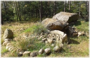
Neolithic and Bronze AgeSite Name: Limeloe Hill Alternative Name: Limelow HillCountry: England County: Hertfordshire Type: Round Barrow(s)
Nearest Town: Royston, Hertfordshire Nearest Village: Littlington, Cambridgeshire
Map Ref: TL3193241949
Latitude: 52.060219N Longitude: 0.077007W
Condition:
| 5 | Perfect |
| 4 | Almost Perfect |
| 3 | Reasonable but with some damage |
| 2 | Ruined but still recognisable as an ancient site |
| 1 | Pretty much destroyed, possibly visible as crop marks |
| 0 | No data. |
| -1 | Completely destroyed |
| 5 | Superb |
| 4 | Good |
| 3 | Ordinary |
| 2 | Not Good |
| 1 | Awful |
| 0 | No data. |
| 5 | Can be driven to, probably with disabled access |
| 4 | Short walk on a footpath |
| 3 | Requiring a bit more of a walk |
| 2 | A long walk |
| 1 | In the middle of nowhere, a nightmare to find |
| 0 | No data. |
| 5 | co-ordinates taken by GPS or official recorded co-ordinates |
| 4 | co-ordinates scaled from a detailed map |
| 3 | co-ordinates scaled from a bad map |
| 2 | co-ordinates of the nearest village |
| 1 | co-ordinates of the nearest town |
| 0 | no data |
Internal Links:
External Links:
Round Barrow(s) in Hertfordshire
About a mile to the North-west of the Five Hills there was until a few years ago a very fine landmark in the tumulus known as Limloe Hill, by the side of the footpath to Litlington. in the Spring of 1891, this fine old hillock was simply carted away and spread over the surrounding field like manure" Sir John Lubbock, in a letter to the writer, suggested that friendly action might possibly save this ancient landmark; but unfortunately it was then too late for any action to be effectual.
Source: The Heath and its Wild flowers - Alfred Kingston p.44
On the 1899 OS map of the area(Hertfordshire IV.NE ) the Barrow is marked with the words 'Human Remains Roman Coins &c found A.D. 1833'
You may be viewing yesterday's version of this page. To see the most up to date information please register for a free account.
Do not use the above information on other web sites or publications without permission of the contributor.
Nearby sites
Download sites to:
KML (Google Earth)
GPX (GPS waypoints)
CSV (Garmin/Navman)
CSV (Excel)
To unlock full downloads you need to sign up as a Contributory Member. Otherwise downloads are limited to 50 sites.
Nearby sites listing. In the following links * = Image available
1.8km S 186° Highfield Farm Barrow Cemetery (TL3178840128)
1.8km NE 35° Bassingbourn Village College ditches Misc. Earthwork (TL3293643488)
2.3km SE 145° The Mile Ditches* Misc. Earthwork (TL3330440132)
2.4km SSE 147° Pen Hills* Barrow Cemetery (TL33263999)
2.5km S 180° The Thrift Round Barrow(s) (TL320394)
2.6km SSE 153° The Devil's Hopscotch* Misc. Earthwork (TL3317939681)
2.7km SSE 153° Church Hill (Royston)* Chambered Tomb (TL3320939600)
2.7km SE 130° Therfield Heath Five Hills* Barrow Cemetery (TL34104025)
2.8km SE 128° Rumbolds Mount Round Barrow(s) (TL34184027)
2.8km SE 130° Therfield Heath Long Barrow* Long Barrow (TL34154017)
3.0km ESE 124° Earl's Hill earthwork* Misc. Earthwork (TL3446540367)
3.0km SE 124° Earl's Hill* Round Barrow(s) (TL3445240335)
3.2km SSW 205° Morden Grange Round Barrow(s) (TL30653901)
3.3km ESE 119° Royston Cricket Pitch Barrow Misc. Earthwork (TL3487540441)
3.4km SE 126° The Two Hills* Barrow Cemetery (TL34724007)
3.4km S 183° Lower Thrift Farm Barrow Round Barrow(s) (TL3184438531)
3.7km ESE 105° Royston Ermine Street Barrow Long Barrow (TL3549241079)
3.8km ESE 109° Royston and District Museum and Art Gallery* Museum (TL3552240812)
3.8km ESE 110° Icenhilde Street Chambered Tomb (TL3550640735)
3.8km S 191° Coombe Farm Round Barrow(s) (TL313382)
3.9km ESE 110° Royston Stone* Natural Stone / Erratic / Other Natural Feature (TL3559440696)
3.9km ESE 110° Royston Cave* Cave or Rock Shelter (TL3561640698)
4.4km SSW 207° Gallows Hill (Hertfordshire)* Round Barrow(s) (TL30023801)
5.3km SW 221° Highley Hill Round Barrow(s) (TL2856637881)
5.3km SW 218° Odsey Round Barrow(s) (TL2880337659)


 We would like to know more about this location. Please feel free to add a brief description and any relevant information in your own language.
 Wir möchten mehr über diese Stätte erfahren. Bitte zögern Sie nicht, eine kurze Beschreibung und relevante Informationen in Deutsch hinzuzufügen.
 Nous aimerions en savoir encore un peu sur les lieux. S'il vous plaît n'hesitez pas à ajouter une courte description et tous les renseignements pertinents dans votre propre langue.
 Quisieramos informarnos un poco más de las lugares. No dude en añadir una breve descripción y otros datos relevantes en su propio idioma.