

<< Our Photo Pages >> Ffrith-Y-Garreg-Wen - Round Barrow(s) in Wales in Flintshire
Submitted by postman on Saturday, 27 September 2014 Page Views: 1799
Neolithic and Bronze AgeSite Name: Ffrith-Y-Garreg-WenCountry: Wales County: Flintshire Type: Round Barrow(s)
Nearest Town: Holywell Nearest Village: Gorsedd
Map Ref: SJ13587589
Latitude: 53.272927N Longitude: 3.297369W
Condition:
| 5 | Perfect |
| 4 | Almost Perfect |
| 3 | Reasonable but with some damage |
| 2 | Ruined but still recognisable as an ancient site |
| 1 | Pretty much destroyed, possibly visible as crop marks |
| 0 | No data. |
| -1 | Completely destroyed |
| 5 | Superb |
| 4 | Good |
| 3 | Ordinary |
| 2 | Not Good |
| 1 | Awful |
| 0 | No data. |
| 5 | Can be driven to, probably with disabled access |
| 4 | Short walk on a footpath |
| 3 | Requiring a bit more of a walk |
| 2 | A long walk |
| 1 | In the middle of nowhere, a nightmare to find |
| 0 | No data. |
| 5 | co-ordinates taken by GPS or official recorded co-ordinates |
| 4 | co-ordinates scaled from a detailed map |
| 3 | co-ordinates scaled from a bad map |
| 2 | co-ordinates of the nearest village |
| 1 | co-ordinates of the nearest town |
| 0 | no data |
Internal Links:
External Links:
")
Located within fifty yards of the fast flowing A55, either park near Mcdonalds and run across the duel carriageway, or park near the roundabout at the Caerwys junction then walk up the gentle hill, fences must be jumped from either direction.
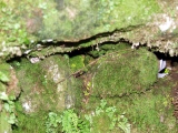
Still quite a big barrow with great views across the Vale of Clwyd and the Clwydian range with all it's hill forts, the duel carriageway detracts somewhat depending upon your outlook.
You may be viewing yesterday's version of this page. To see the most up to date information please register for a free account.
")
")
Do not use the above information on other web sites or publications without permission of the contributor.
Nearby sites
Download sites to:
KML (Google Earth)
GPX (GPS waypoints)
CSV (Garmin/Navman)
CSV (Excel)
To unlock full downloads you need to sign up as a Contributory Member. Otherwise downloads are limited to 50 sites.
Nearby sites listing. In the following links * = Image available
1.5km ENE 61° Y Gorseddau* Round Barrow(s) (SJ149766)
1.7km ESE 111° Holywell Racecourse* Round Barrow(s) (SJ15177526)
1.8km ENE 65° Gorsedd Church* Standing Stones (SJ152766)
1.9km ESE 117° Bwrdd y Rhyfel 1* Round Barrow(s) (SJ1523075000)
2.4km SE 134° Babell Round Barrow(s) (SJ153742)
2.4km NNE 24° Whitford Inscribed Stone* Early Christian Sculptured Stone (SJ146781)
2.5km W 269° Traveller's Inn* Round Barrow(s) (SJ111759)
2.5km NNE 23° Whitford Church Inscribed Stone Early Christian Sculptured Stone (SJ146782)
3.0km NNW 346° Maen Achwyfan* Ancient Cross (SJ129788)
3.1km SE 145° Waen Isaf Round Barrow(s) (SJ153733)
3.2km E 100° Naid-y-March* Standing Stones (SJ16767528)
3.2km E 100° Naid-Y-March* Standing Stones (SJ1676775288)
3.4km SE 129° Gatehouse Farm Round Barrow(s) (SJ162737)
3.5km WNW 282° Hendre Bach Round Barrow(s) (SJ10137671)
3.7km ENE 61° Ffynnon Oswald Holy Well or Sacred Spring (SJ1688577622)
3.9km W 274° Pany Y Dulath Round Barrow(s) (SJ09677624)
4.0km ESE 108° Brynford* Barrow Cemetery (SJ174746)
4.0km WSW 237° Coed Bron Fawr* Barrow Cemetery (SJ10167372)
4.3km W 272° Criafol* Round Barrow(s) (SJ09317611)
4.9km E 85° St Winefrides Well* Holy Well or Sacred Spring (SJ18517627)
5.0km SE 131° Plas Captain* Cairn (SJ17367253)
5.1km WSW 251° Moel Maen Efa* Barrow Cemetery (SJ087743)
5.2km WNW 295° Cae Bryn Round Barrow(s) (SJ08917821)
5.2km SE 130° Llwyn Erddyn* Ring Cairn (SJ17567249)
5.3km SW 228° Cefn Du Ancient Village or Settlement (SJ0956272450)


 We would like to know more about this location. Please feel free to add a brief description and any relevant information in your own language.
 Wir möchten mehr über diese Stätte erfahren. Bitte zögern Sie nicht, eine kurze Beschreibung und relevante Informationen in Deutsch hinzuzufügen.
 Nous aimerions en savoir encore un peu sur les lieux. S'il vous plaît n'hesitez pas à ajouter une courte description et tous les renseignements pertinents dans votre propre langue.
 Quisieramos informarnos un poco más de las lugares. No dude en añadir una breve descripción y otros datos relevantes en su propio idioma.